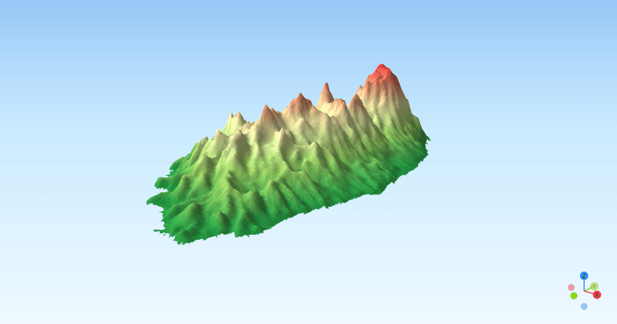

Digital Elevation Models (DEMs) are digital representations of the elevation or height of the earth's surface. They are created using remote sensing techniques, such as LiDAR or satellite imagery, and are widely used in the field of construction. DEMs can provide accurate information about the topography of the land, which is crucial in determining the feasibility and suitability of a construction project. In this context, DEMs can be used to derive several important datasets, which can be useful for a variety of construction projects. Let's look at some of the derivatives of DEMs and their applications in different construction projects:
Road construction
DEMs can be used to derive datasets such as slope, aspect, and curvature. These datasets can provide valuable information about the terrain, which is important in planning the alignment and design of roads. For example, slope data can help engineers identify areas of the road that are prone to landslides or erosion. Aspect data can help identify areas that are exposed to wind or sun, which can affect the safety and comfort of drivers. Curvature data can help identify areas where the road needs to be designed with more or less banking.
Building of drainage systems
DEMs can be used to derive datasets such as flow direction, flow accumulation, and stream order. These datasets can provide valuable information about the hydrology of the land, which is important in designing drainage systems. For example, flow direction data can help engineers identify the direction of water flow and design drainage systems that are effective in diverting water away from buildings or roads. Flow accumulation data can help engineers identify areas where water is likely to accumulate and design drainage systems that can handle large volumes of water.
Dam and reservoir construction
DEMs can be used to derive datasets such as volume and capacity. These datasets can provide valuable information about the amount of water that can be stored in a reservoir or behind a dam. For example, volume data can help engineers estimate the amount of water that can be stored in a reservoir and design the dam accordingly. Capacity data can help engineers determine the maximum amount of water that a dam can hold and design the spillway accordingly.
Building foundation
DEMs can be used to derive datasets such as slope stability, bearing capacity, and settlement. These datasets can provide valuable information about the stability of the ground and the suitability of the site for constructing high buildings. For example, slope stability data can help engineers identify areas where the ground is prone to landslides or erosion and design foundations that can withstand these hazards. Bearing capacity data can help engineers determine the maximum load that the ground can support and design foundations that can distribute the weight of the building evenly. Settlement data can help engineers predict the amount of settlement that the building will undergo and design foundations that can accommodate these movements.
Excavation of Earth Meterials
DEMs can be used to derive datasets such as cut and fill volume. These datasets can provide valuable information about the amount of earth that needs to be excavated or added to a site. For example, cut volume data can help contractors estimate the amount of earth materials that needs to be removed from a site to prepare it for construction. Fill volume data can help contractors estimate the amount of earth that needs to be added to a site to level it for construction.
Site grading
DEMs can be used to derive datasets such as slope and elevation contours. These datasets can provide valuable information about the topography of the site and the amount of grading that needs to be done. For example, slope data can help contractors identify areas where the ground needs to be leveled or sloped to prevent erosion or improve drainage. Elevation contour data can help contractors determine the best locations for roads, parking lots, or buildings to minimize the amount of grading that needs to be done.
In conclusion, Digital Elevation Models (DEMs) are essential tools in the field of construction. They can provide accurate and detailed information about the topography and elevation of the land, which is crucial in determining the feasibility and suitability of a construction project.