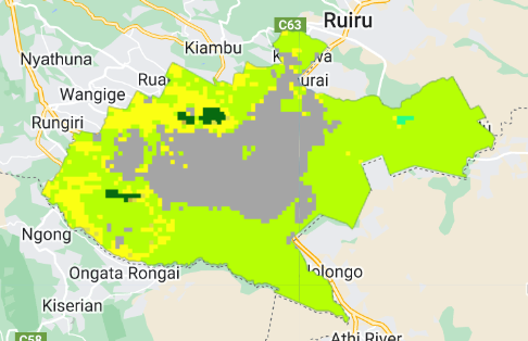
In this project focused on "Nairobi Night Time Light Statistics," I began by filtering the administrative boundaries of Nairobi from the GeoBoundaries dataset and visualized the selected region on the map. The primary datasets utilized include the EOG VIIRS Annual Composites for Night-Time Lights (NTL) and the MODIS Land Cover Type for the year.
The Night-Time Lights dataset was filtered for the specific year 2020 within the bounds of Nairobi. The resulting NTL image was then visualized using a defined color palette, showcasing the intensity of nighttime lights in the selected region.
Simultaneously, the MODIS Land Cover dataset was filtered for the same year, focusing on the IGBP land cover classification. The land cover image was visualized with a distinct color palette, providing insights into the land cover types present in Nairobi during the specified period.
This project effectively demonstrates the use of Earth Engine and its capabilities in handling and visualizing geospatial datasets. The combination of Night-Time Lights and Land Cover information contributes to a holistic understanding of the urban dynamics in Nairobi, offering valuable insights into the interplay between human activity and the natural environment.
The aim of the "Nairobi Night Time Light Statistics" project was to analyze and visualize nocturnal urban dynamics in Nairobi, Kenya, using geospatial data. The project focused on two key datasets: the EOG VIIRS Annual Composites for Night-Time Lights and the MODIS Land Cover Type for the year 2020. By filtering and extracting relevant information within the administrative boundaries of Nairobi, the project aimed to provide insights into the intensity of nighttime lights and the corresponding land cover types in the region. The visualizations generated from these datasets contribute to a comprehensive understanding of urban development and human activity patterns, offering valuable information for urban planning and environmental management in Nairobi.
https://code.earthengine.google.com/0042d0cb0cebaa07a4ce77710b8bacdf


![Lexical Map of [Shovel] in Malay Lang](/_next/image?url=https%3A%2F%2Fstorage.googleapis.com%2Fspatialnodefiles%2Fprojects%2FPetaDialekCangkul1_9000385.png&w=3840&q=100)