Sign up or log in to your Spatialnode account.

Takes less than a few seconds.

Land Cover Map for Machinga, Malawi

Olive Caroline Mandalasi
Olive Caroline Mandalasi•

June 28, 2023

Land Cover Map for Machinga, Malawi

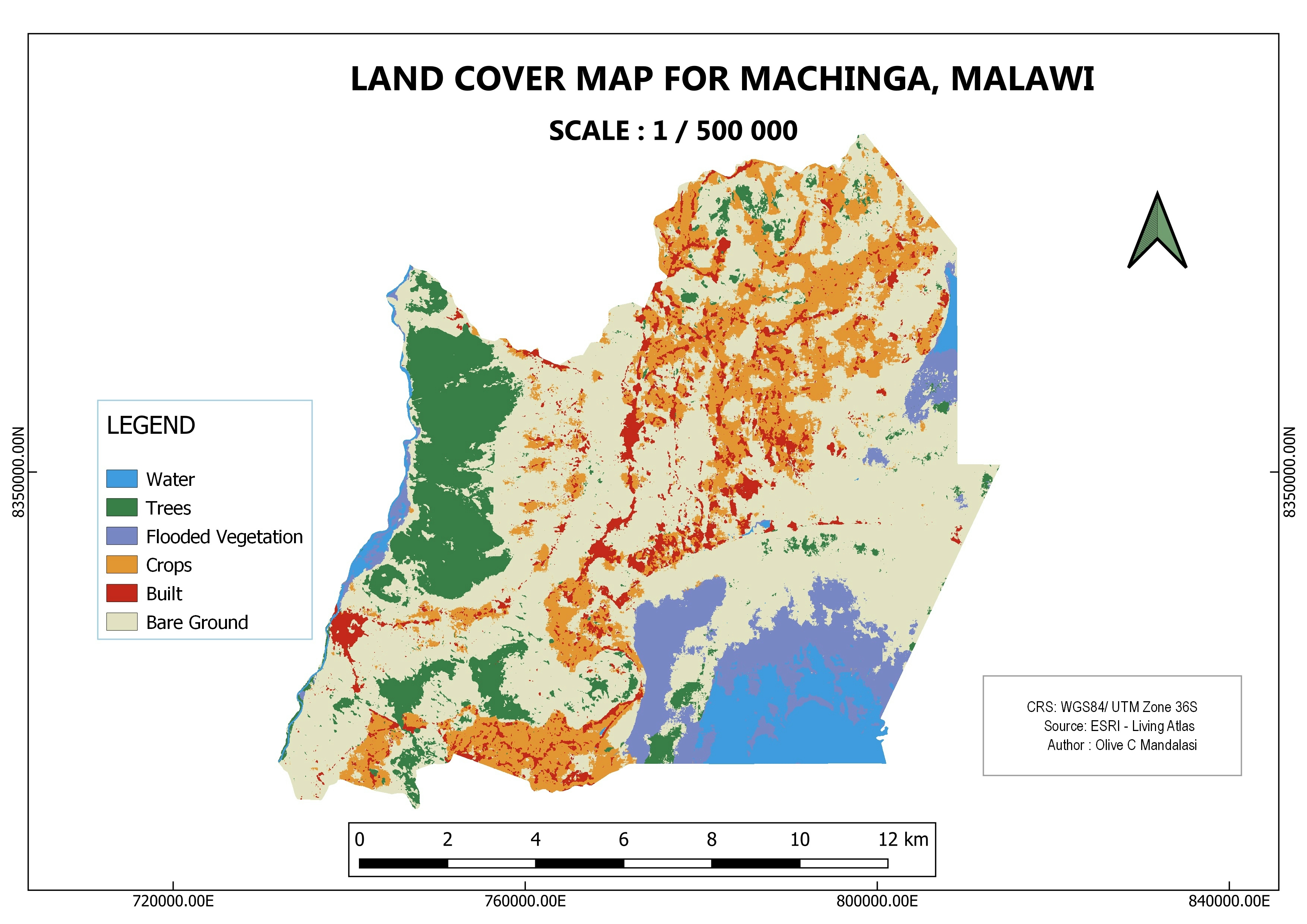
Land cover map of a district in Malawi, Machinga

Demo

Tools used

ArcGIS Living Atlas Of The WorldQGIS

Plug-ins used

N/A

tags

landcover

You might also like

GEE Practicums with EEFA Book Authors
Zach Torres
GEE Practicums with EEFA Book Authors
Zach Torres
110
Parque Natural Municipal Chico Mendes
Dennis A. Britto
Parque Natural Municipal Chico Mendes
Dennis A. Britto
13
Air Pollution and Population Trends
erica chaif
Air Pollution and Population Trends
erica chaif
13
Map of Waterlines in Troutdale, Oregon
Liam Patterson
Map of Waterlines in Troutdale, Oregon
Liam Patterson
12
Seattle Tree Species and Coverage
Anna
Seattle Tree Species and Coverage
Anna
21
3a: Demographics and Health in Illinois
Patrick Ansell
3a: Demographics and Health in Illinois
Patrick Ansell
13
Mapa de Localização das Escolas do Proj
Arthur Igreja dos Santos
Mapa de Localização das Escolas do Proj
Arthur Igreja...
18
ÁREAS POTENCIAIS
MICHAEL LUCAS DA SILVA SA
ÁREAS POTENCIAIS
MICHAEL LUCAS...
7
England Rainfall Data - Maps From API
Connor Merrell
England Rainfall Data - Maps From API
Connor Merrell
33
BH do rio Andirá, uso e cobertura
Andrei Tavares Fernandes
BH do rio Andirá, uso e cobertura
Andrei Tavares Fernandes
10
Blue Acres Home Buyouts in New Jersey
DILLAN PATEL
Blue Acres Home Buyouts in New Jersey
DILLAN PATEL
25
Digitization of geological data from the database of the Geological and Mining Research Center ,DRC
IVES MALONGO KOKINAMBILI
Digitization of geological data from the database of the Geological...
IVES MALONGO KOKINAMBILI
226

Join the community!

We're a place where geospatial professionals showcase their works and discover opportunities.

Sign Up for free