Sign up or log in to your Spatialnode account.

Takes less than a few seconds.

ARMED CONFLICTS IN NIGERIA

Idris Halima Ohunene
Idris Halima Ohunene•

February 01, 2022

ARMED CONFLICTS IN NIGERIA

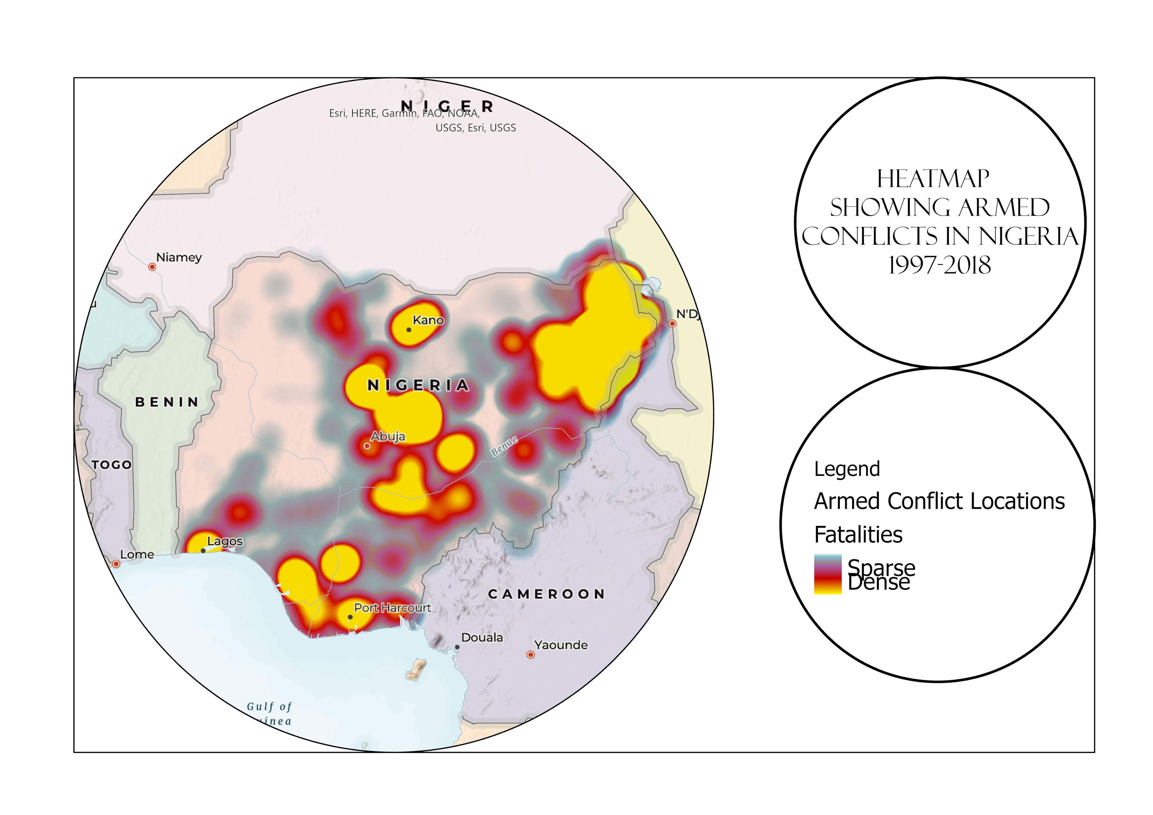
The map shows armed conflicts in Nigeria based on number of fatalities from 1997 to 2018


Tools used

ArcGIS Pro

Plug-ins used

ArcGIS Online

tags

heatmap

More by Idris Halima Ohunene

POPULATION BOOM!!! (ABUJA)
51
A TRIP TO EKO ATLANTIC CITY
16

You might also like

Leeds City Centre in 3D
Adriana Calderon
Leeds City Centre in 3D
Adriana Calderon
206
Morfometría del Río de Las Salinas
Ramiro Alejandro Ferrau
Morfometría del Río de Las Salinas
Ramiro Alejandro Ferrau
34
MAP OF FARM OVERLAID ON CLASSIFIED IMAGE
Edidiong Ekrikpo
MAP OF FARM OVERLAID ON CLASSIFIED IMAGE
Edidiong Ekrikpo
6
Class Project - Tsunami Hazard Analysis
Dane Lewandowski
Class Project - Tsunami Hazard Analysis
Dane Lewandowski
13
Urban Agenda Canary Islands
Gerardo Ezequiel Martín Carreño
Urban Agenda Canary Islands
Gerardo Ezequiel...
44
Mapa - Produção Ágricola no Brasil 2016
Felipe Duarte de Castro
Mapa - Produção Ágricola no Brasil 2016
Felipe Duarte...
64
Mapping Out Obesity Rates in Illinois
Ani Pearn
Mapping Out Obesity Rates in Illinois
Ani Pearn
3
Diving Monterey Atlas
Andrew Middleton
Diving Monterey Atlas
Andrew Middleton
320
Satellite data for land cover mapping
Kareen Bröker
Satellite data for land cover mapping
Kareen Bröker
44
Pierce County Map Book
Rhonda Parrish, GISP
Pierce County Map Book
Rhonda Parrish, GISP
6
Mapa de Identificação de Talhões
Layanara Faria
Mapa de Identificação de Talhões
Layanara Faria
47
Map a Month: May
Cari Lynn Squibb
Map a Month: May
Cari Lynn Squibb
17

Join the community!

We're a place where geospatial professionals showcase their works and discover opportunities.

Sign Up for free