Sign up or log in to your Spatialnode account.

Takes less than a few seconds.

Average Temperature PR 1981 to 2010

Jonathan Correa Varela
Jonathan Correa Varela•

February 15, 2024

Average Temperature PR 1981 to 2010

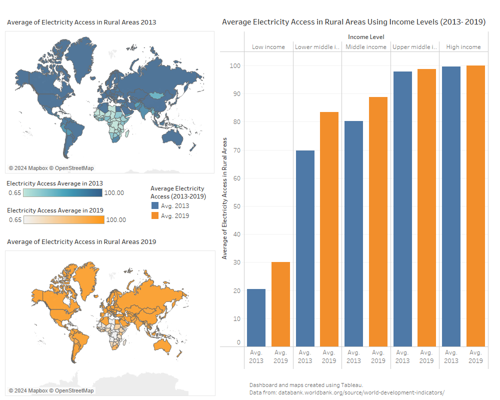
Isopleth map of the average temperature of Puerto Rico from 1981 to 2010 using weather stations across the island.


Plug-ins used

ArcGIS Pro

tags

climateTemperatura

More by Jonathan Correa Varela

Hazardous Waste Treatment in Michigan
16
NYC Food Stamps By Neighboorhood
36
Average Electricity Access Rural Areas
14
Hydrographic basins of Puerto Rico
52
Firearm Mortality Rate & Presidency 2020
17

You might also like

SUB-BACIA DO RIO MEIRIM - ALAGOAS
Priscila Andreza dos Santos Buarque
SUB-BACIA DO RIO MEIRIM - ALAGOAS
Priscila Andreza...
47
Seattle Tree Species and Coverage
Anna
Seattle Tree Species and Coverage
Anna
20
Spatial Assessment Public Restrooms NYC
Metehan Demirkol
Spatial Assessment Public Restrooms NYC
Metehan Demirkol
21
Hipsometria do corrego Marrecas
luiz felipe maçon
Hipsometria do corrego Marrecas
luiz felipe maçon
6
AGOL - GIS Request Management Solution
Jeffrey Erwin
AGOL - GIS Request Management Solution
Jeffrey Erwin
10
COVID19 VACCINATION UPTAKE VISUALIZATION
Mary Muthee
COVID19 VACCINATION UPTAKE VISUALIZATION
Mary Muthee
26
ÍNDICE DE VULNERABILIDADE SOCIOAMBIENTAL
Francielle Caminhas
ÍNDICE DE VULNERABILIDADE SOCIOAMBIENTAL
Francielle Caminhas
10
Número de cadastros nas UBS
Priscila Andreza dos Santos Buarque
Número de cadastros nas UBS
Priscila Andreza...
9
Land Use and Occupation of Três Corações
Kauê Santos Lima
Land Use and Occupation of Três Corações
Kauê Santos Lima
30
Image processing example
Fernando Santos
Image processing example
Fernando Santos
11
Evidence of Geomorphology- Stream Piracy
Temidayo Fabiyi
Evidence of Geomorphology- Stream Piracy
Temidayo Fabiyi
33
DC Schools Safe Walk Map
Tyler Holmes
DC Schools Safe Walk Map
Tyler Holmes
7

Join the community!

We're a place where geospatial professionals showcase their works and discover opportunities.

Sign Up for free