Sign up or log in to your Spatialnode account.

Takes less than a few seconds.

IDENTIFICAÇÃO - SETOR VULNERABILIDADE

Francielle Caminhas
Francielle Caminhas•

March 23, 2022

IDENTIFICAÇÃO - SETOR VULNERABILIDADE

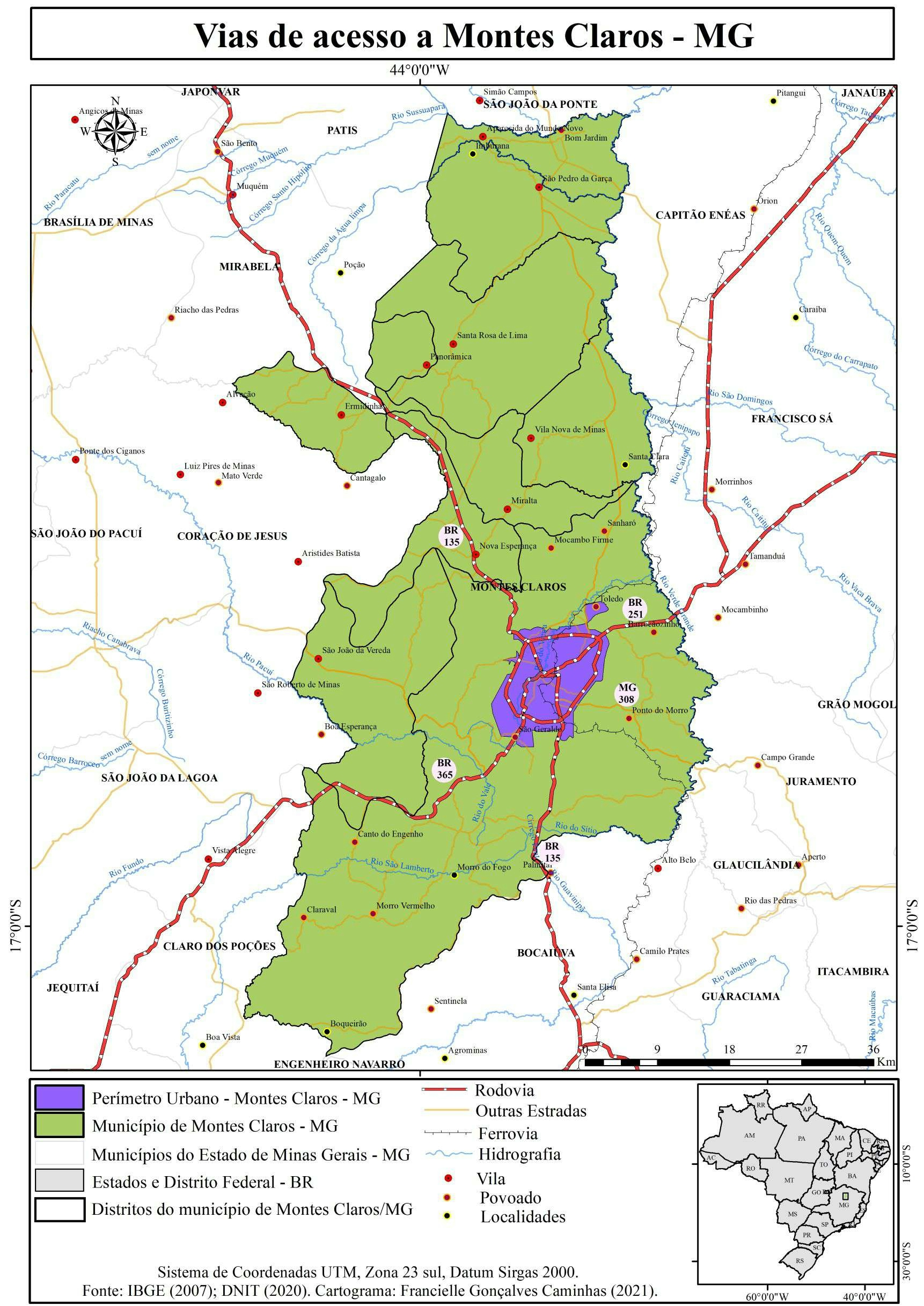
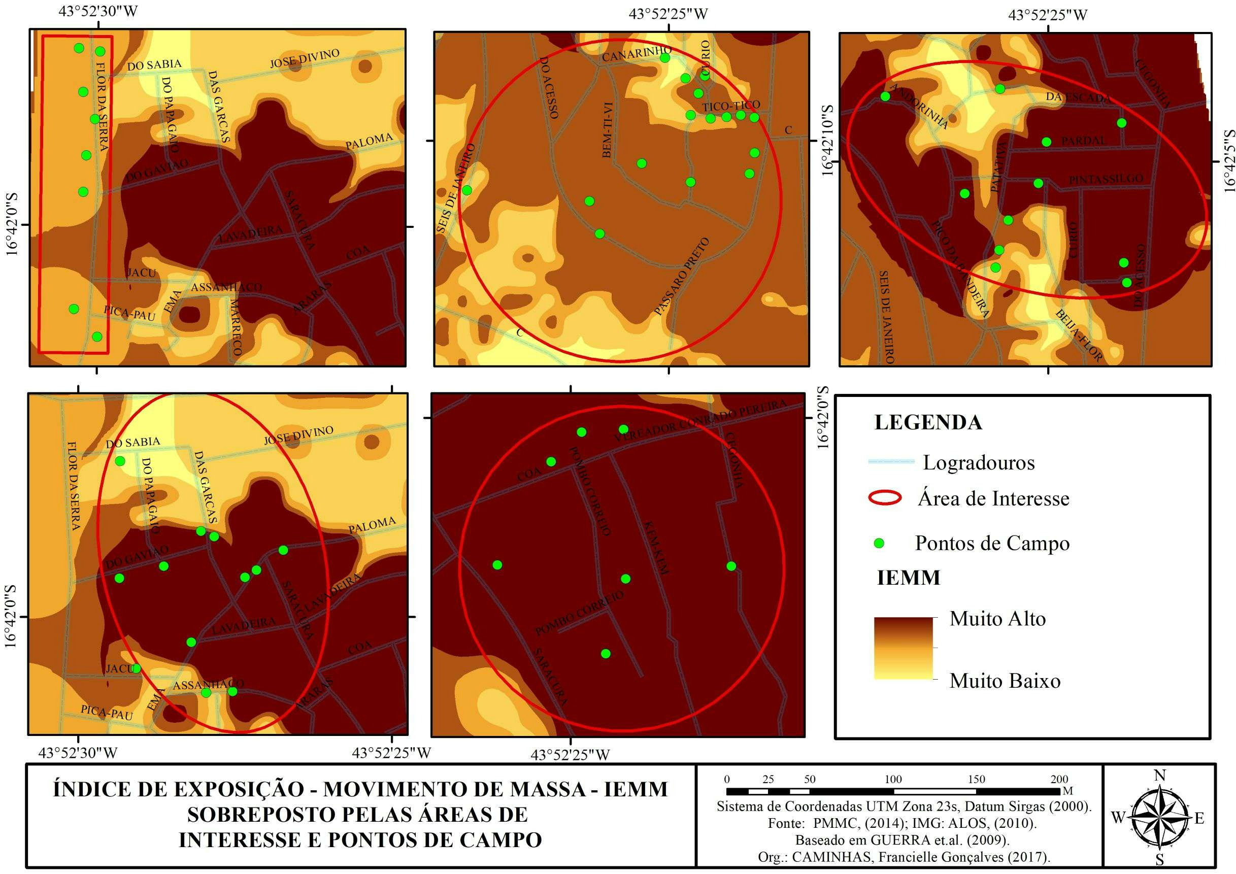
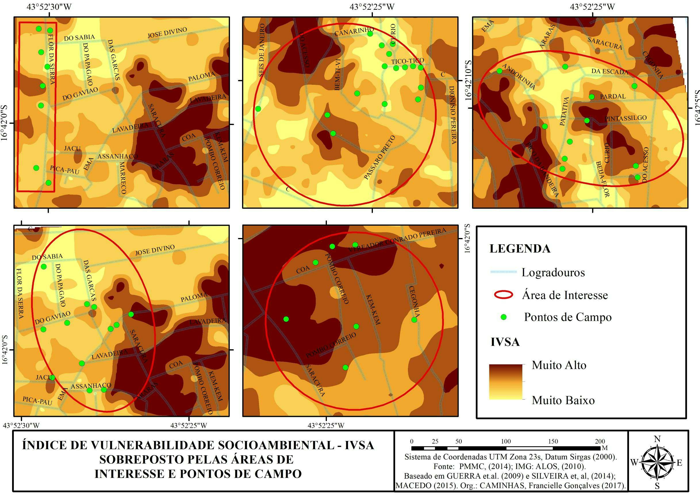
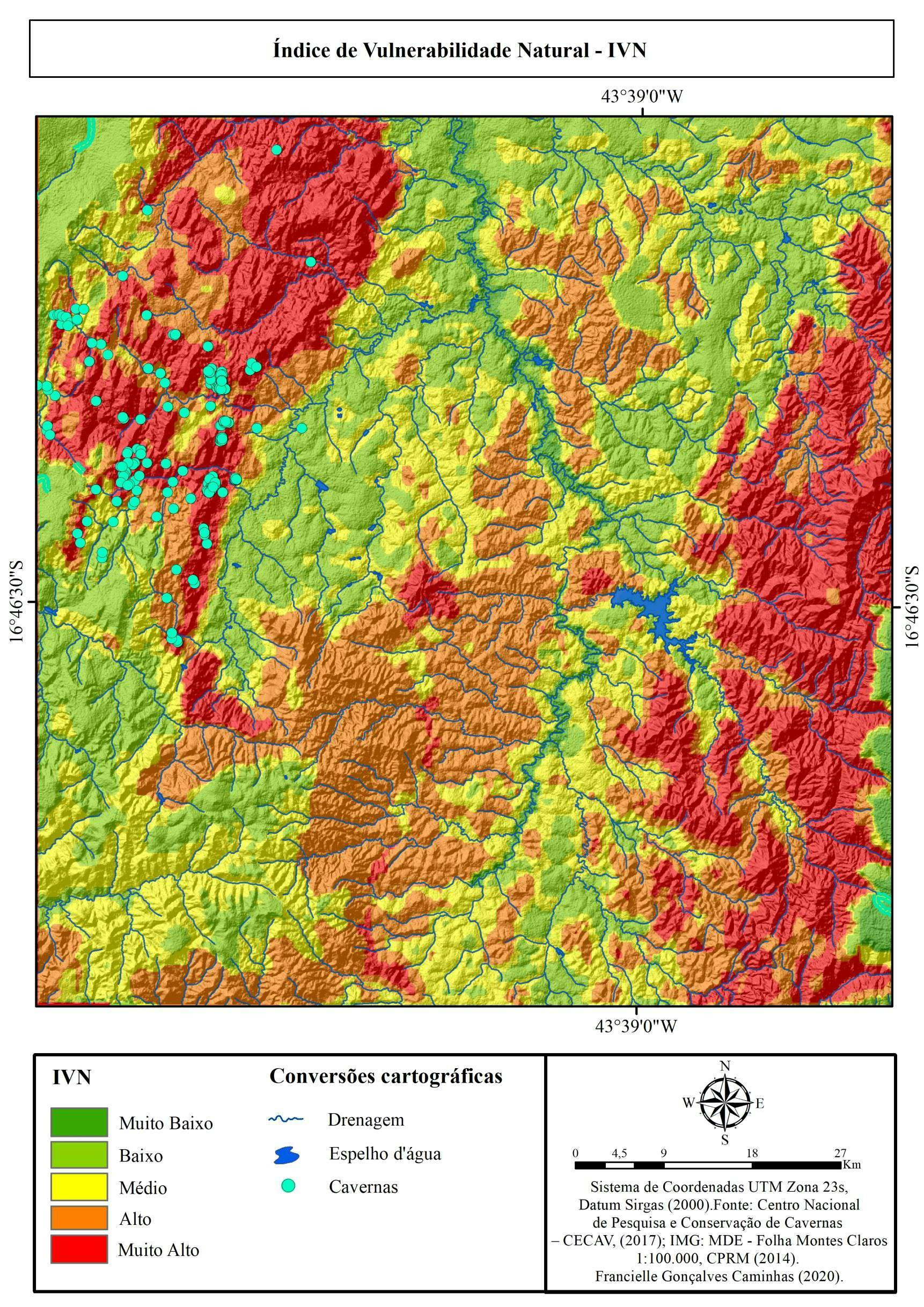
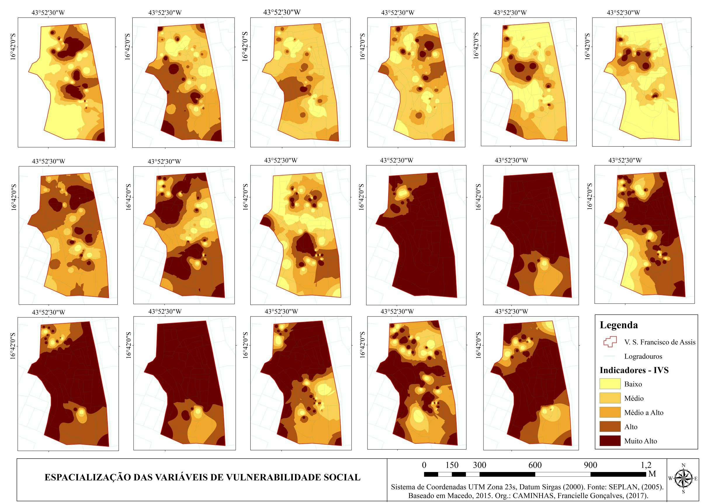
Identificação geográfica de um Setor de Vulnerabilidade Socioambiental na Vila São Francisco de Assis, Montes Claros, Minas Gerais - MG.


Tools used

ArcGIS

Plug-ins used

ArcGIS

tags

ArcGISArcMap

More by Francielle Caminhas

IVN - Montes Claros, Minas Gerais (MG)
6
PARÂMETROS DE EVOLUÇÃO DA PAISAGEM
13
Vias de acesso - Montes Claros - MG
53
Índice de Concentração de Rugosidade
7
Distribuição das barraginhas UPGRH - SF8
83
Parâmetros Físicos Montes Claros - MG
94
ÍNDICE DE EXPOSIÇÃO - MOVIMENTO DE MASSA
9
Vulnerabilidade Social - V. S Fran Assis
13
ÍNDICE DE VULNERABILIDADE SOCIOAMBIENTAL
9

You might also like

Bigquery GIS - NYC Bikes availability
Paola Prieto Botero
Bigquery GIS - NYC Bikes availability
Paola Prieto Botero
18
South Sudan Grid Routing
Emmanuel Oyerinde
South Sudan Grid Routing
Emmanuel Oyerinde
72
Pearl River, Louisiana
Hugo Pereira Lima
Pearl River, Louisiana
Hugo Pereira Lima
12
Inspiração Artesanal
Rayanne Cardoso
Inspiração Artesanal
Rayanne Cardoso
15
Driving Analysis
Laura Scott
Driving Analysis
Laura Scott
29
Zoneamento Plano Diretor Recife
Renata Maciel
Zoneamento Plano Diretor Recife
Renata Maciel
28
Área de estudo Faixa Nova
Gustavo Soares Arrial
Área de estudo Faixa Nova
Gustavo Soares Arrial
60
Elevation Map Bay of Bengal (Bangladesh)
Loviena Garcia
Elevation Map Bay of Bengal (Bangladesh)
Loviena Garcia
13
Spectral profile of point(western Egypt)
Sarah Abd Elsamea
Spectral profile of point(western Egypt)
Sarah Abd Elsamea
74
Carte de localisation  Saint Contest
Elhadji Mamadou DIAKHABY
Carte de localisation Saint Contest
Elhadji Mamadou DIAKHABY
12
Near Tour
Gift Uhiene
Near Tour
Gift Uhiene
76
Digital Terrian Model for MCE Analysis
Emmet O Donnell
Digital Terrian Model for MCE Analysis
Emmet O Donnell
17

Join the community!

We're a place where geospatial professionals showcase their works and discover opportunities.

Sign Up for free