
Building on key data efforts produced by the Tampa Bay Regional Planning Council (TBRPC), University of South Florida (USF) and University of Florida (UF), the REACH project has defined a goal of creating a consistent methodology and GIS user guide to standardize the way the region conducts housing vulnerability assessments for flood risks and future sea level rise.
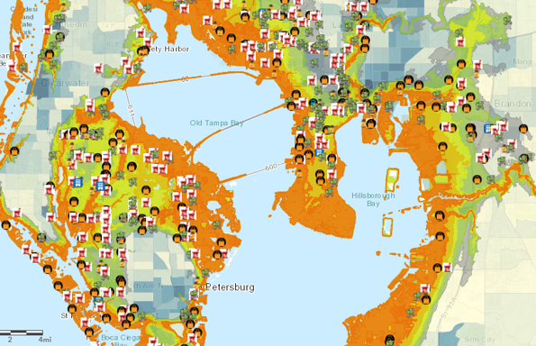
In Spring 2020, the TBRPC, USF and UF Tampa Bay Regional Planning Council, University of Florida and University of South Florida Masters in Urban Planning Program faculty and researchers collaborated to develop criteria for housing and mapping symbiology. The USF MURP graduate students conducted housing inundation and vulnerability analysis for 10 community areas in six counties. The initial mapping information will be reviewed and presented on May 6, 2021.
The Housing Assessment used the following data sets:
Flood Risks
- Category 1 Storm Surge (2020)
- Category 3 Storm Surge (2020)
- Evacuation Zones
- NOAA Intermediate High 2070 Sea Level Rise & Exceptional (King) Tides
Housing Factors
- Assisted multi family buildings and total units
- Unassisted multi family and single family buildings and total units
- Unassisted housing below $180,000
- Year built, construction type, funding source
- Mobile homes and mobile home parks
Social Vulnerability Data
- Age – 75 years and up
- Household Income – Area median income
- Minority Population


.svg "Keran Nkongolo")


