Sign up or log in to your Spatialnode account.

Takes less than a few seconds.

Topografia Parque Nacional do Caparaó

Vitória Serra Bernardes
Vitória Serra Bernardes•

January 04, 2022

Topografia Parque Nacional do Caparaó

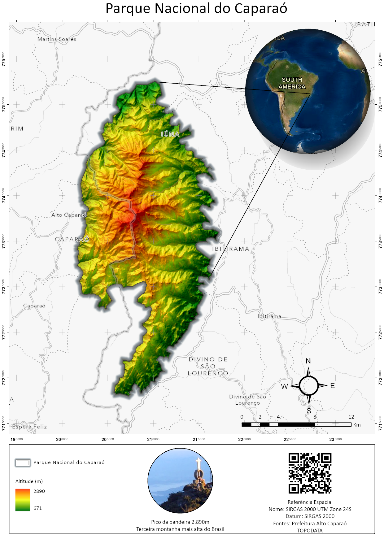
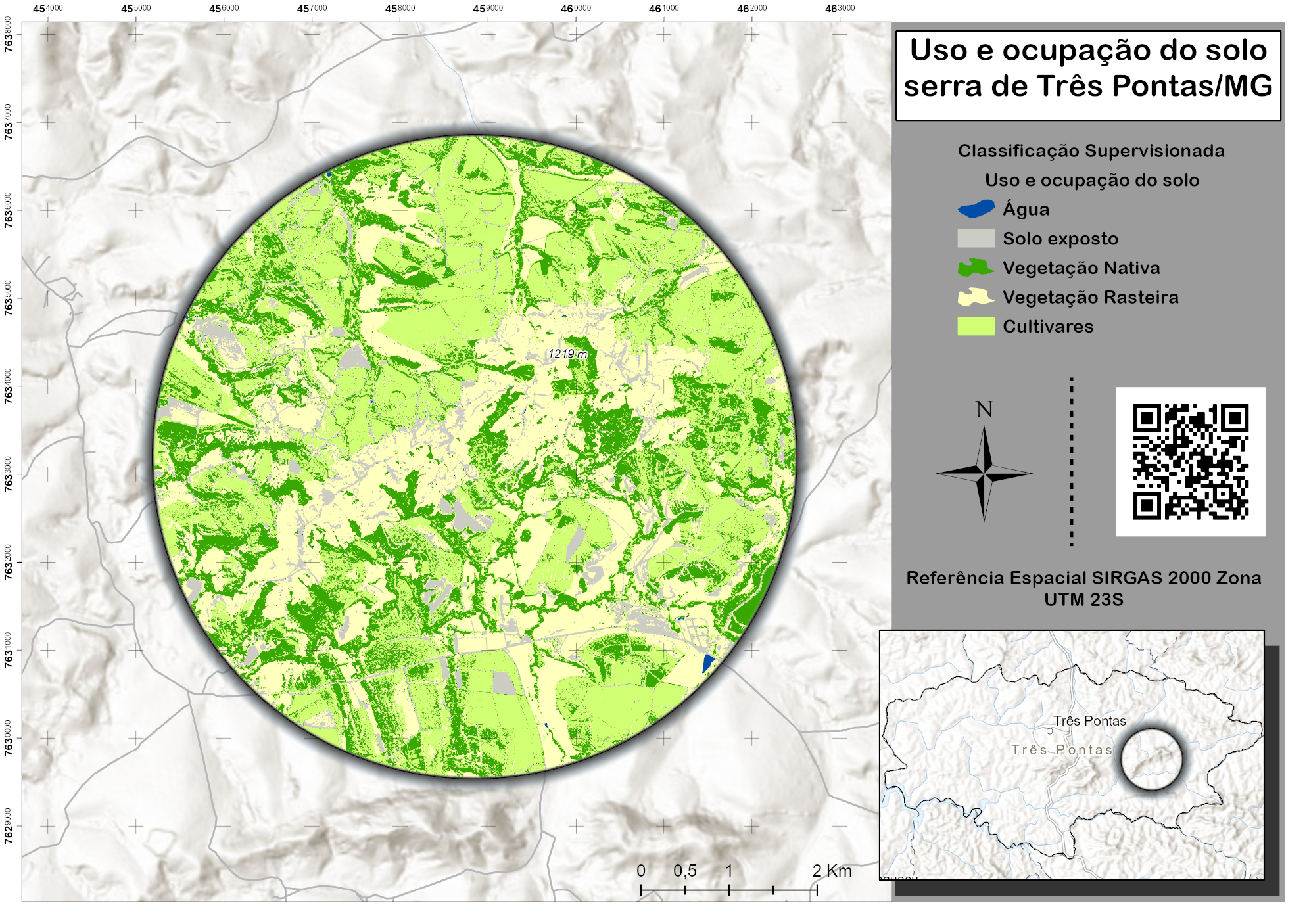
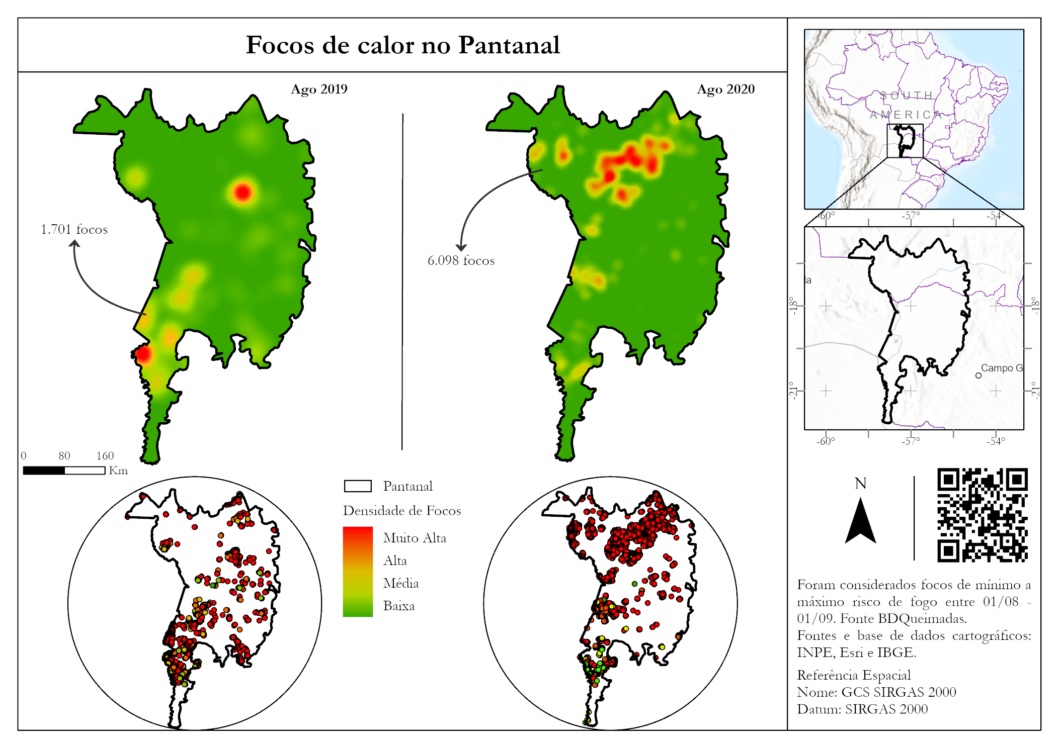
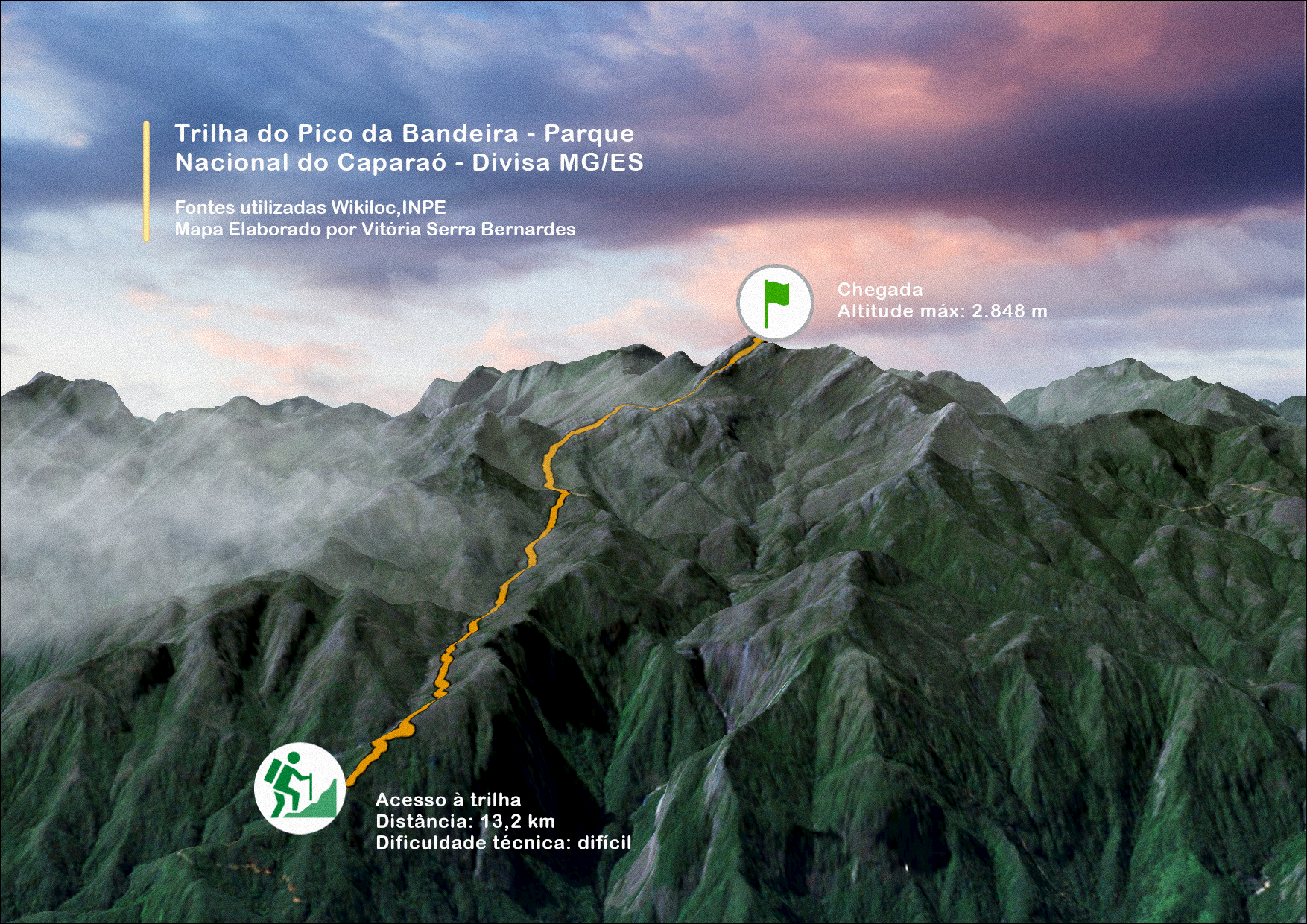
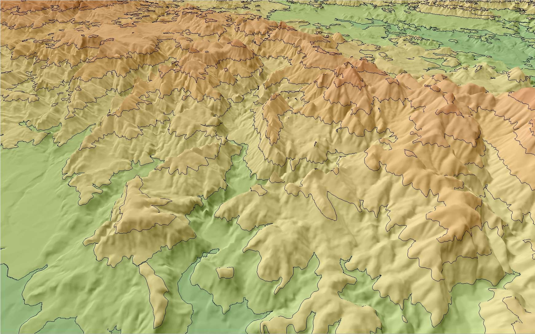
Parque Nacional do Caparaó - ES/MG, part. 1/3


Tools used

hillshade

Plug-ins used

ArcGIS Pro

tags

parque nacional do caparaótopographic map

More by Vitória Serra Bernardes

Trilha Pico da Bandeira
384
Mapa de NDVI
Mapa de NDVI
195
Normalized Burn Ratio
168
Shiva Temple (Grand Canyon) - Arizona
192
Bioma, UCs e Áreas Prioritárias
478
Travessia Rancho Caído
382
Yellowstone National Park - USGS 1956
173
Focos de incêndio no Pantanal
335
Vista Iluminada do Pico da Bandeira
477
Trilha do Ouro - Serra da Bocaina
407
Different way to see world
171
Focos de incêndio em Minas Gerais
229

You might also like

USING NDWI indice to understand flooding
Craig Tolliver
USING NDWI indice to understand flooding
Craig Tolliver
30
Pecora 21 Poster
Jill Derwin
Pecora 21 Poster
Jill Derwin
20
Traffic-Related Severe Injuries
Ireoluwa Orodiji
Traffic-Related Severe Injuries
Ireoluwa Orodiji
21
Artistic map - Roman roads
Fabrício H. Oda
Artistic map - Roman roads
Fabrício H. Oda
40
Missouri Impaired Lakes
Keran Nkongolo
Missouri Impaired Lakes
Keran NkongoloPro
21
Del Norte ATP Planning/ Safety Analysis
Stefan R Melko
Del Norte ATP Planning/ Safety Analysis
Stefan R MelkoPro
1
SUSTAINABLE TOURIST SITES
Mary Muthee
SUSTAINABLE TOURIST SITES
Mary Muthee
42
Land Change in Loudon County
Jason Boatjri
Land Change in Loudon County
Jason Boatjri
20
Bad Map of the Month Series
Timothy Brink
Bad Map of the Month Series
Timothy BrinkPro
13
LOCALIZAÇÃO DA REPÚBLICA DO HAITI
Itamar Sateles de Sá
LOCALIZAÇÃO DA REPÚBLICA DO HAITI
Itamar Sateles...
372
Soil Suceptibility to Erosion Map
Paul Ugbong
Soil Suceptibility to Erosion Map
Paul Ugbong
47
Declividades do Rio de JAneiro - RJ
LETICIA MARIA LEAL MALHEIROS
Declividades do Rio de JAneiro - RJ
LETICIA MARIA...
25

Join the community!

We're a place where geospatial professionals showcase their works and discover opportunities.

Sign Up for free