Sign up or log in to your Spatialnode account.

Takes less than a few seconds.

Mapa de declividade

Jailson Sandes Barbosa de Oliveira
Jailson Sandes Barbosa de Oliveira•

February 24, 2022

Mapa de declividade

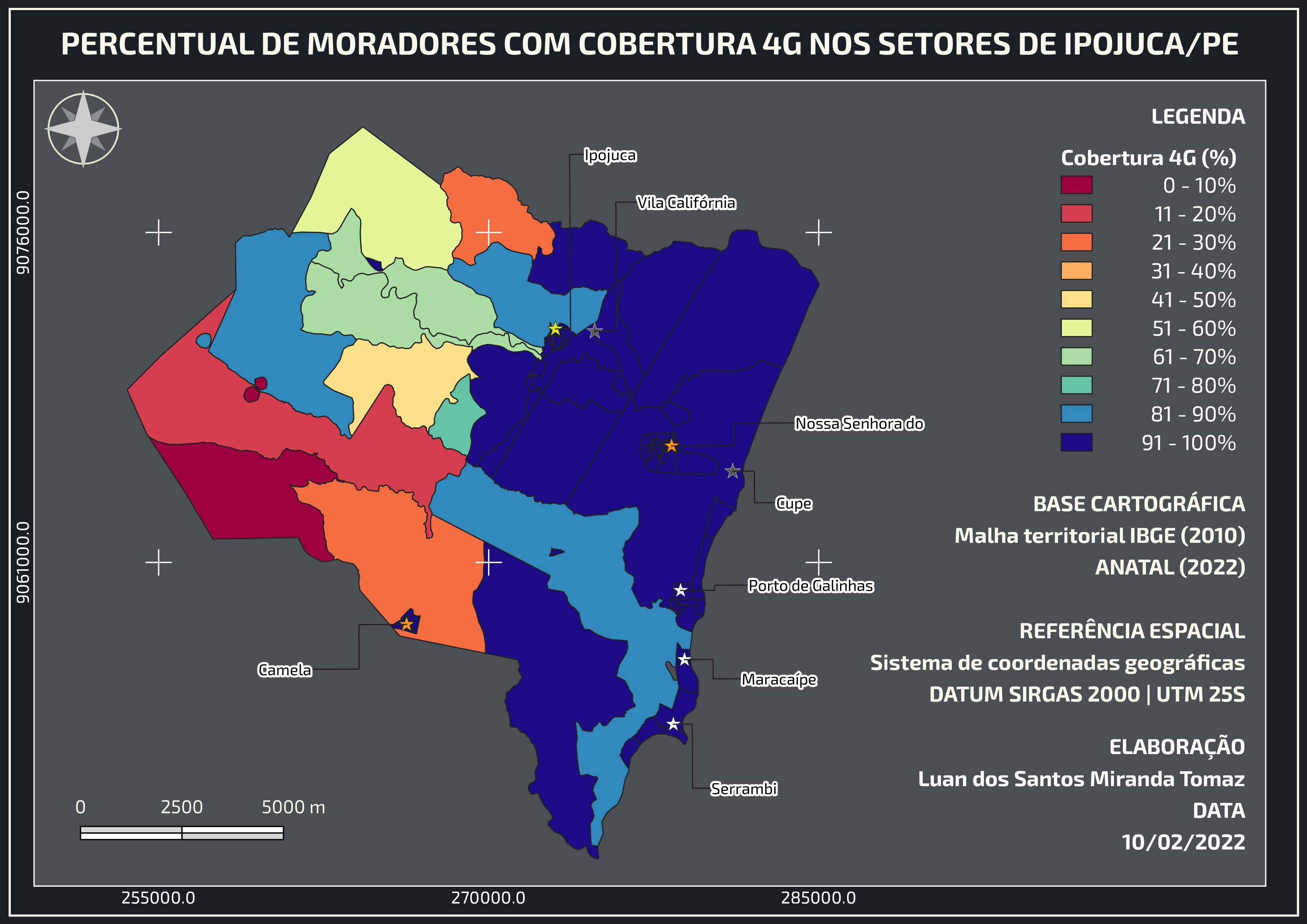
Mapa de declividade para a cidade de Maceió / AL.


Tools used

Qgis 3.16.8 Hannover

Plug-ins used

SRTM NASA

tags

declividade maceio

More by Jailson Sandes Barbosa de Oliveira

Pedologia - Barra de São Miguel / AL
4

You might also like

Land Use Change
Elizabeth Rule
Land Use Change
Elizabeth Rule
29
Tree Species Distribution
Satyam Soni
Tree Species Distribution
Satyam Soni
39
Targeted Analysis of Illinois Data
erica chaif
Targeted Analysis of Illinois Data
erica chaif
16
Mapa Artístico - Mar de Kattegat
LETICIA MARIA LEAL MALHEIROS
Mapa Artístico - Mar de Kattegat
LETICIA MARIA...
146
TOPOGRAPHY OF GOMBE STATE, NIGERIA.
Nathan Angbashim
TOPOGRAPHY OF GOMBE STATE, NIGERIA.
Nathan Angbashim
72
GLOBAL WARMING ANALYSIS
Durojaye Olusegun
GLOBAL WARMING ANALYSIS
Durojaye Olusegun
95
Tree Canopy Cover of São Gabriel City
Matheus Medici
Tree Canopy Cover of São Gabriel City
Matheus Medici
11
Driving Analysis
Laura Scott
Driving Analysis
Laura Scott
27
Incêndio Florestal
Simone Malhado da Silva
Incêndio Florestal
Simone Malhado...
3
4c: Modifying Water Infrastructure Map
Patrick Ansell
4c: Modifying Water Infrastructure Map
Patrick Ansell
10
Bad Map
Adam O Dolce
Bad Map
Adam O Dolce
34
Supervised classification image of Hall County, Georgia
Kolawole Arowoogun
Supervised classification image of Hall County, Georgia
Kolawole Arowoogun
254

Join the community!

We're a place where geospatial professionals showcase their works and discover opportunities.

Sign Up for free