Sign up or log in to your Spatialnode account.

Takes less than a few seconds.

Modelo Digital de Elevação - Alto Iguaçu

DOUGLAS HENRIQUE MANOEL PEREIRA
DOUGLAS HENRIQUE MANOEL PEREIRA•

July 10, 2023

Modelo Digital de Elevação - Alto Iguaçu

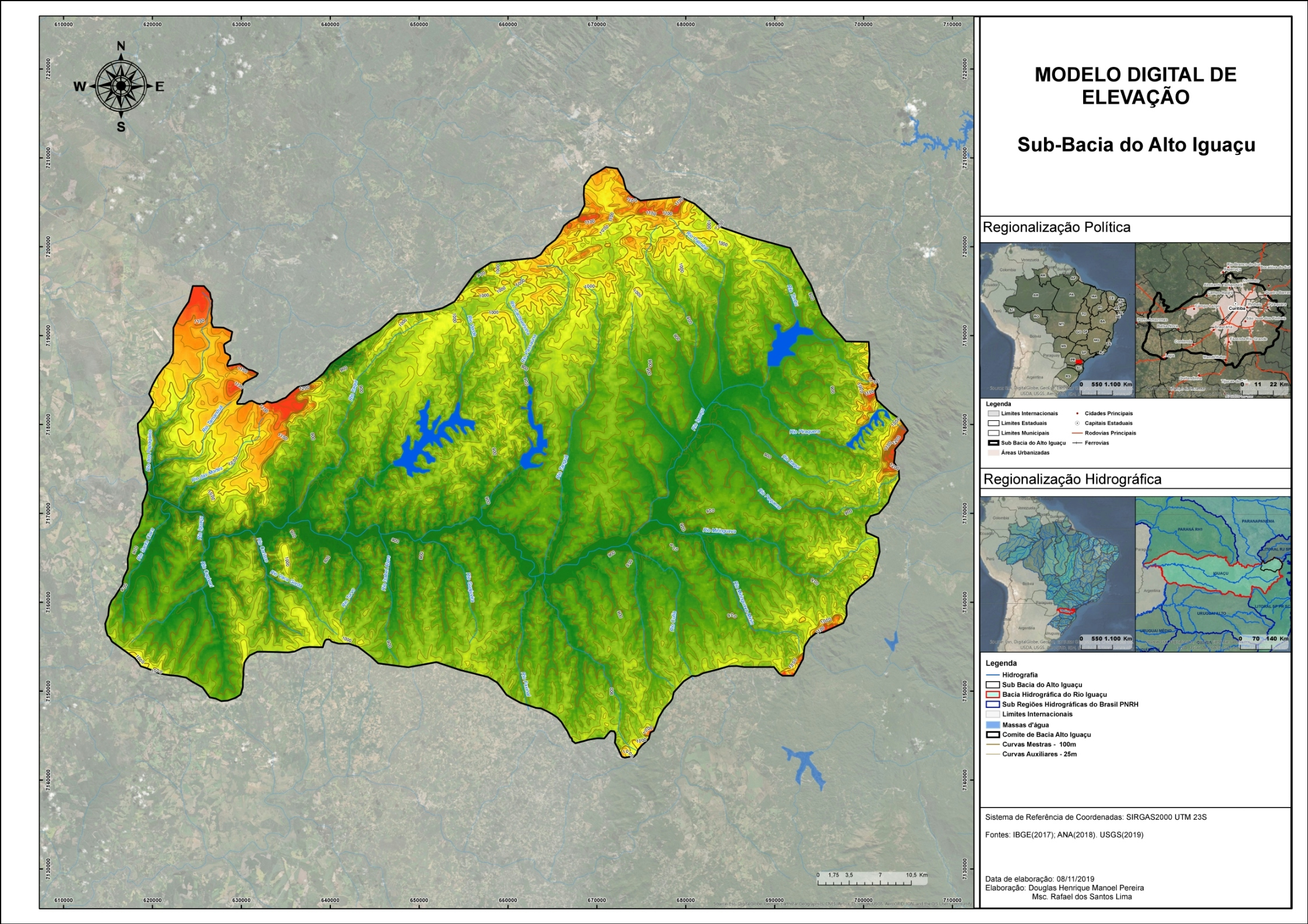
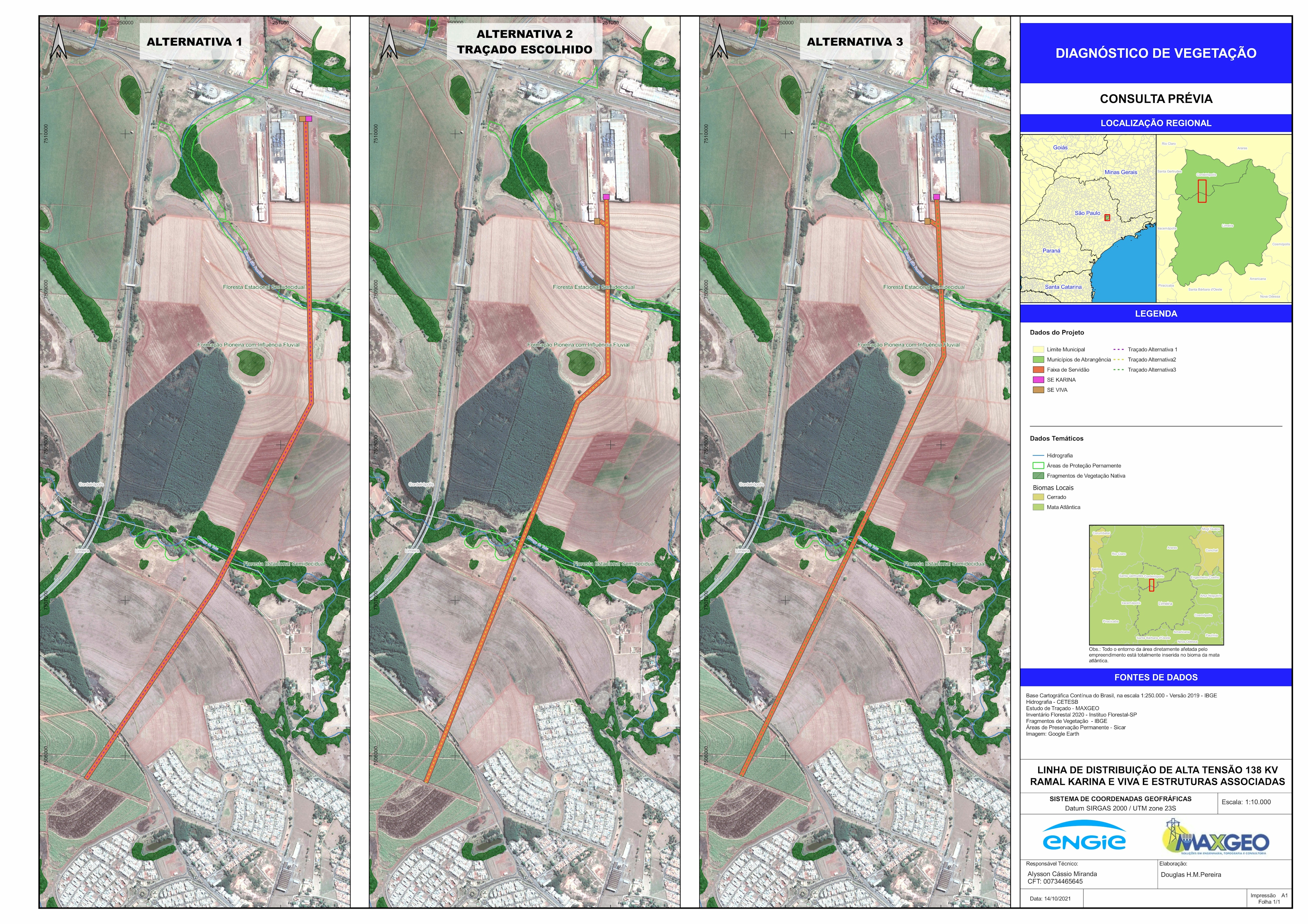
Hidrografia e hipsometria da região hidrográfica do Alto Iguaçu.
Mapeamento realizado como subsídio para a disciplina de hidrografia ministrada pelo rofessor Rafael dos Santos Lima. 


Tools used

ArcGIS Pro

Plug-ins used

ArcGIS Pro

tags

ArcGIS Pro

More by DOUGLAS HENRIQUE MANOEL PEREIRA

Diagnóstico de Vegetação
7
Planta Cadastral da Faixa de Servidão
29
Vulnerabilidade Ambiental
9
Unidades Litológicas
22
Propriedades Interferidas
22
Análise Temporal de Focos de Calor
9
Floresta Nacional de Ipanema, Iperó - SP
19
Subestação Junqueirópolis
5
Análise da Paisagem por Índices
8

You might also like

Mapping - Project Development
Jeffrey Erwin
Mapping - Project Development
Jeffrey Erwin
8
Active fire in the last 7 days
Balogun Temitope
Active fire in the last 7 days
Balogun Temitope
340
City of Fife Online Permitting Portal
Rhonda Parrish, GISP
City of Fife Online Permitting Portal
Rhonda Parrish, GISP
8
Traverses of Geophysical Survey, Unilag
Emeka Ude
Traverses of Geophysical Survey, Unilag
Emeka Ude
10
Choosing Projections
Zach Torres
Choosing Projections
Zach Torres
58
Dam records on SDM future projection
Philip Russo
Dam records on SDM future projection
Philip Russo
372
Spatiotemporal trend of SUHI in Ondo
Esther Ayomide Adeniji
Spatiotemporal trend of SUHI in Ondo
Esther Ayomide Adeniji
47
Diamond_Mineral Deposits and Exploration
Miriela Ulloa Santana
Diamond_Mineral Deposits and Exploration
Miriela Ulloa Santana
62
ROUTE NETWORK ANALYSIS
Dee Geodata Sage
ROUTE NETWORK ANALYSIS
Dee Geodata Sage
12
Environmental Justice in Mitigation
Simone Chapman
Environmental Justice in Mitigation
Simone Chapman
140
Mapeamento urbano de Curitiba
Fernanda Rezende
Mapeamento urbano de Curitiba
Fernanda Rezende
18
Geneva in Rayshader
Adriana Calderon
Geneva in Rayshader
Adriana Calderon
86

Join the community!

We're a place where geospatial professionals showcase their works and discover opportunities.

Sign Up for free