Sign up or log in to your Spatialnode account.

Takes less than a few seconds.

Planta Cadastral da Faixa de Servidão

DOUGLAS HENRIQUE MANOEL PEREIRA
DOUGLAS HENRIQUE MANOEL PEREIRA•

July 10, 2023

Planta Cadastral da Faixa de Servidão

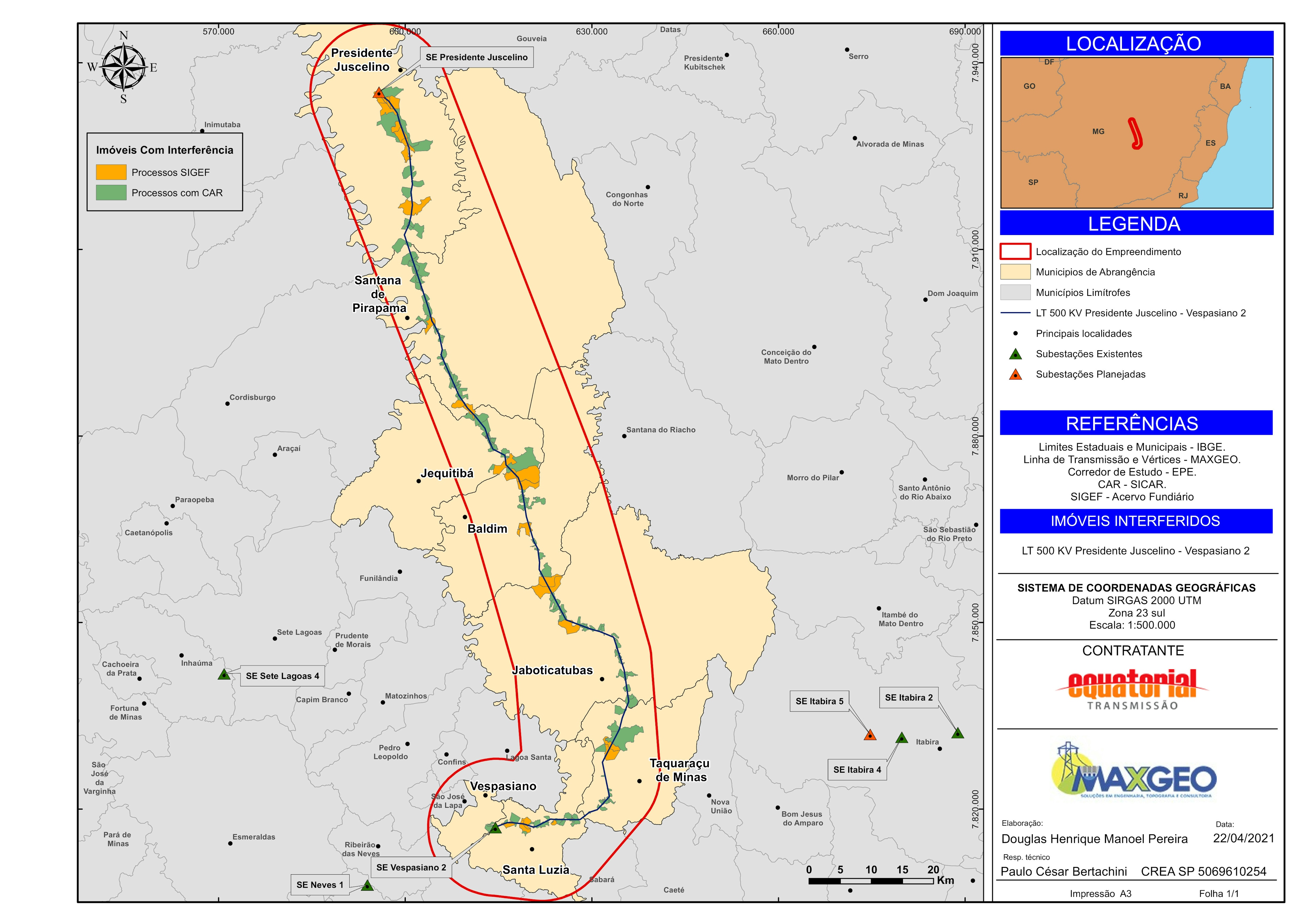
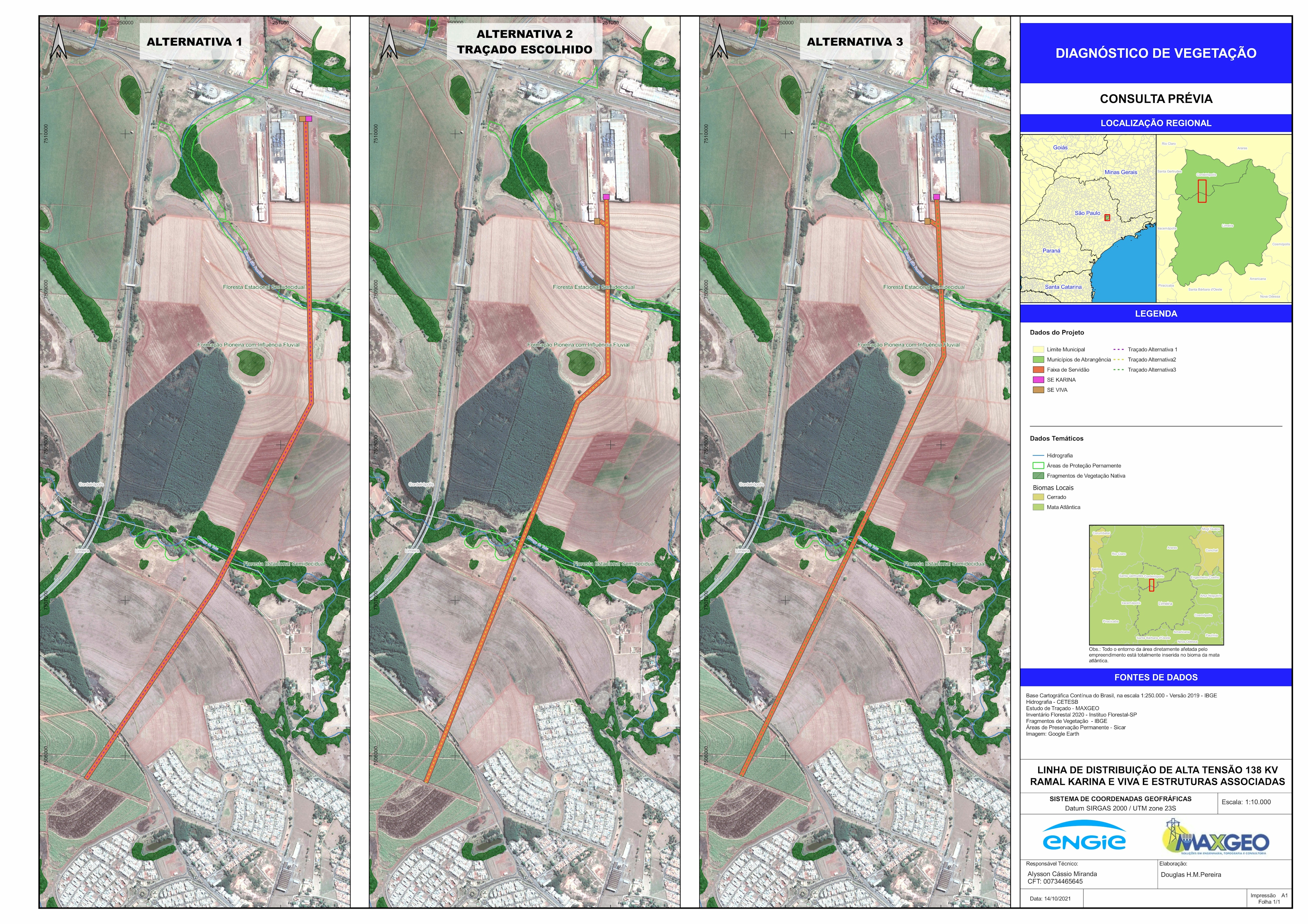
Planta Cadastral de faixa de servidão para linhas de transmisão com o objetivo de identificar á area interferida e as benfeitorias impactadas.


Tools used

ArcGIS Pro

Plug-ins used

ArcGIS

tags

ArcGIS

More by DOUGLAS HENRIQUE MANOEL PEREIRA

Unidades Litológicas
23
Vulnerabilidade Ambiental
12
Subestação Junqueirópolis
6
Modelo Digital de Elevação - Alto Iguaçu
19
Floresta Nacional de Ipanema, Iperó - SP
24
Propriedades Interferidas
22
Análise Temporal de Focos de Calor
10
Diagnóstico de Vegetação
8
Análise da Paisagem por Índices
10

You might also like

Deforestation rate out of CAR overlap
Rayane Pacheco
Deforestation rate out of CAR overlap
Rayane Pacheco
60
Hurricanes since 1851
Lukumon Lateef
Hurricanes since 1851
Lukumon Lateef
18
Quesnel Best Available Pixel Composite
Michael Burnett
Quesnel Best Available Pixel Composite
Michael Burnett
7
NEPA/Environmental Justice Pop. Analysis
Benjamin Landry
NEPA/Environmental Justice Pop. Analysis
Benjamin Landry
14
Sobrevoo
ANDRE NOBREGA DE ARRUDA
Sobrevoo
ANDRE NOBREGA...
4
Brazil - Federal elections (2018 - 2022)
Rafael Pinheiro Machado
Brazil - Federal elections (2018 - 2022)
Rafael Pinheiro Machado
134
ESRI Redistricter: Election Law in LA
Benjamin Landry
ESRI Redistricter: Election Law in LA
Benjamin Landry
11
Physical Geography Map of Oaxaca, Mexico
Laura Scott
Physical Geography Map of Oaxaca, Mexico
Laura Scott
10
Environmental Zoning
rafael menezes de souza
Environmental Zoning
rafael menezes...
44
Rio das Velhas
Matheus Amaral Prates
Rio das Velhas
Matheus Amaral Prates
9
NDVI Map of Fulton County
Kolawole Arowoogun
NDVI Map of Fulton County
Kolawole Arowoogun
75
Roanoke Land Cover Classification
Jason Boatjri
Roanoke Land Cover Classification
Jason Boatjri
30

Join the community!

We're a place where geospatial professionals showcase their works and discover opportunities.

Sign Up for free