Objective:
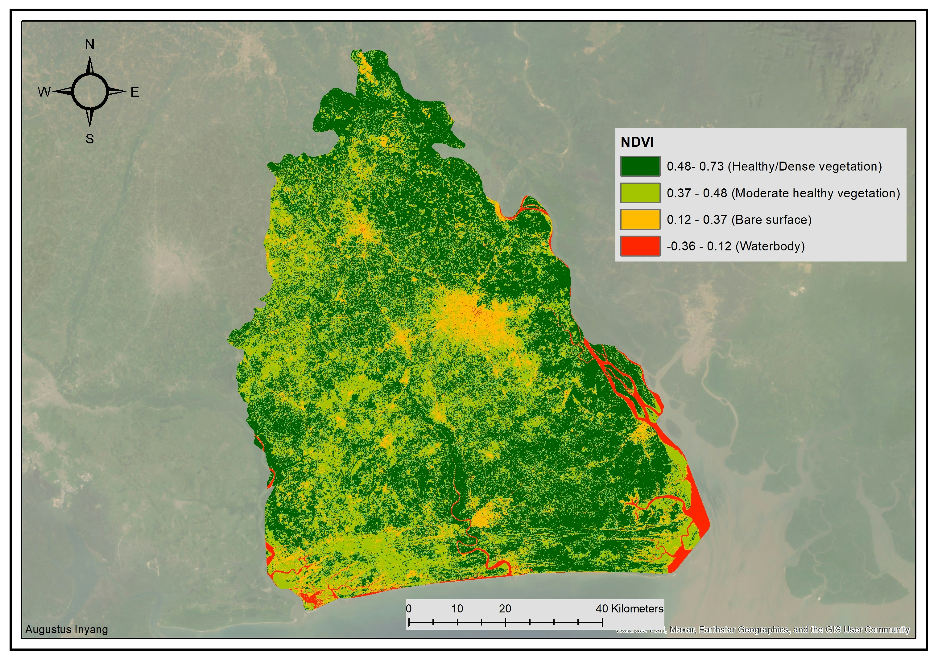
The objective of this Normalize Difference Vegetation Index (NDVI) project is to analyze the vegetation health and distribution of an area in Akwa Ibom, Nigeria
Methodology:
Sentinel-2 satellite imagery was downloaded from Google Earth Engine (GEE), and the NDVI values were computed using the formula (NIR-Red)/(NIR+Red), where NIR represents the near-infrared band and Red represents the red band. The Sentinel-2 satellite imagery was used as the data source, and the NDVI values were classified into different categories based on their ranges as described above.
Findings:
The NDVI map shows that the area in Akwa Ibom has a mix of different land covers, including vegetation, bare surfaces, and water bodies. The dense/healthy vegetation, with NDVI values ranging from 0.48 to 0.73, indicates that the area has a high density of green vegetation with a healthy canopy cover. The moderate healthy vegetation, with NDVI values ranging from 0.37 to 0.48, indicates that the area has a moderate density of green vegetation with a healthy canopy cover. The bare surface, with NDVI values ranging from 0.23 to 0.37, indicates areas with little or no vegetation, and the water bodies, with NDVI values ranging from -0.36 to 0.12, indicate areas with a high reflectance in the near-infrared band and a low reflectance in the red band.
Conclusion:
The NDVI map provides important information about the vegetation health and distribution of the area in Akwa Ibom, Nigeria. The high density of dense/healthy vegetation, along with the moderate density of moderate healthy vegetation, indicates that the area has a mix of areas with high and moderate productivity. On the other hand, the bare surfaces with low NDVI values indicate areas with limited resources for vegetation growth. The presence of water bodies, as indicated by low NDVI values, is also an important aspect of the landscape. This NDVI map can support decision-making in various fields such as resource management, conservation, and land-use planning. However, it is important to keep in mind that NDVI values are influenced by several factors, and the results of the analysis should be validated with additional information and data.


.svg "Keran Nkongolo")