Sign up or log in to your Spatialnode account.

Takes less than a few seconds.

3D Hexbins of Food Resources in LA

Whitney
Whitney•

December 19, 2024

3D Hexbins of Food Resources in LA

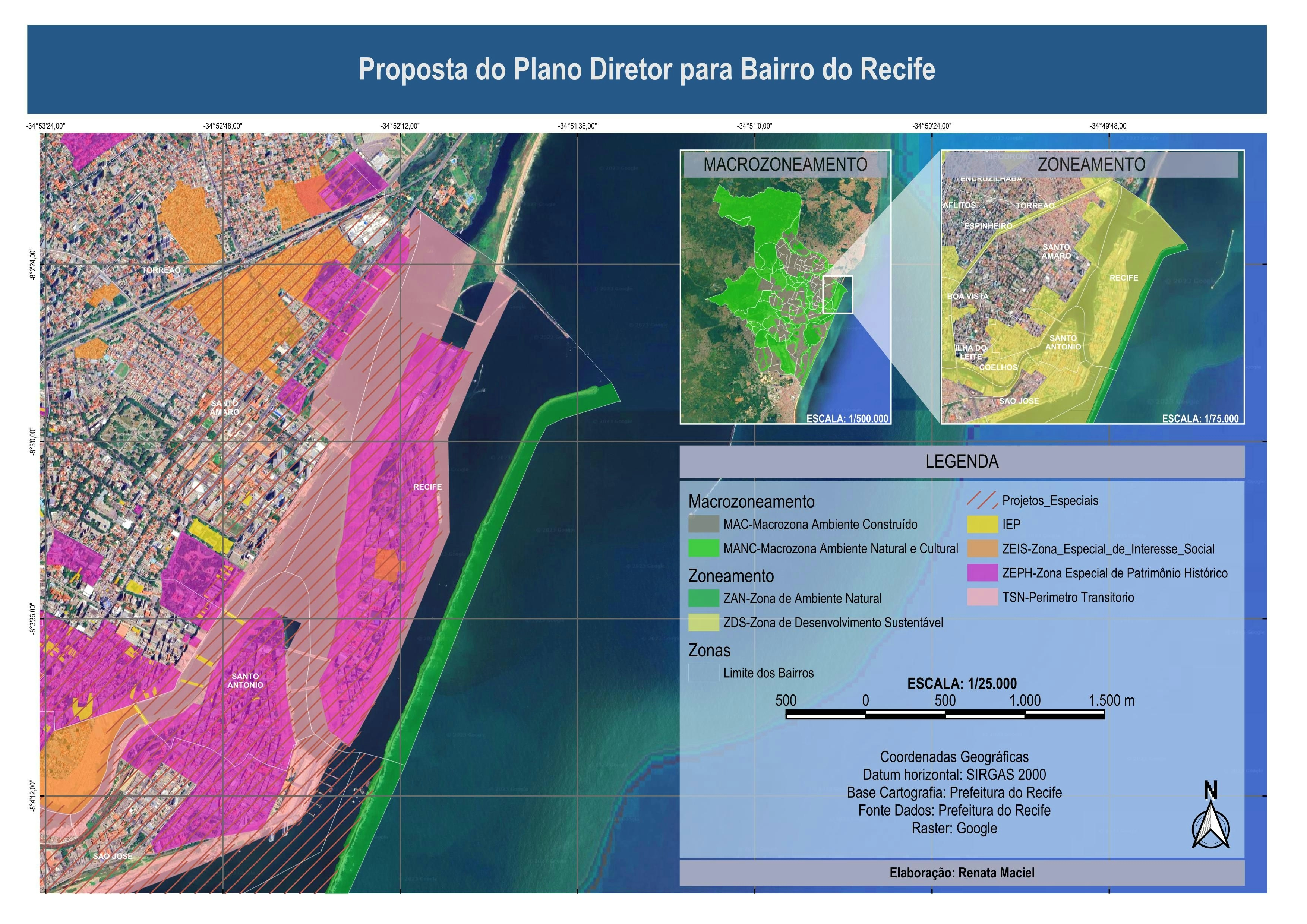
This project maps the locations of free food resources in Los Angeles using hexbins. Each hexbin is five miles and each food resource in a bin displays as one mile of elevation and a darker color on the gradient. arcg.is/11Ha581


Plug-ins used

geojsonJavascript

tags

hexagonsSpatial Analysis

More by Whitney

Population without a Vehicle
12
Bus Accessibility in Ventura County
9
Poverty and Food Access in LA County
57
The Impacts of Noise and Air Pollution
11
Population with Limited English
14
States by Bachelor's Degree
16
Free Food Resources in Los Angeles
9

You might also like

Beltrami County Adopt-A-Highway
Isaac Ajayi
Beltrami County Adopt-A-Highway
Isaac AjayiPro
8
Nevados-Bacia do lago Sibinacocha-Peru
Felipe Ferreira Monteiro
Nevados-Bacia do lago Sibinacocha-Peru
Felipe Ferreira Monteiro
125
Story Board, Idaho Military Division
Michael Nau
Story Board, Idaho Military Division
Michael Nau
43
Mapa de identificação de solo
Paulo Ricardo Gomes de Souza
Mapa de identificação de solo
Paulo Ricardo...
128
Electric Vehicle Charging Stations
Christopher DeGarmo
Electric Vehicle Charging Stations
Christopher DeGarmo
7
Cobertura do uso do solo - Amazonas
Lucas de Morais Teixeira
Cobertura do uso do solo - Amazonas
Lucas de...
9
Elevation Interpolation
Farhan Towsif
Elevation Interpolation
Farhan Towsif
2
Mapa de Uso e Ocupação do Solo
Breno Nunes
Mapa de Uso e Ocupação do Solo
Breno Nunes
49
PRISM Precipitation Data in Hex
Michael Nau
PRISM Precipitation Data in Hex
Michael Nau
53
 Geospatial Data Management Integration
Peter Kimani
Geospatial Data Management Integration
Peter Kimani
12
(Field Work) Insti Maps for Libmanan LGU
Juan Carlos Gabriel Zacarias
(Field Work) Insti Maps for Libmanan LGU
Juan Carlos...
15
Historical Fiction Reference Map
Sherri Michl
Historical Fiction Reference Map
Sherri Michl
13

Join the community!

We're a place where geospatial professionals showcase their works and discover opportunities.

Sign Up for free