Sign up or log in to your Spatialnode account.

Takes less than a few seconds.

Coosa River, Al USA - REM

Matt Dempsey
Matt Dempsey•

October 18, 2024

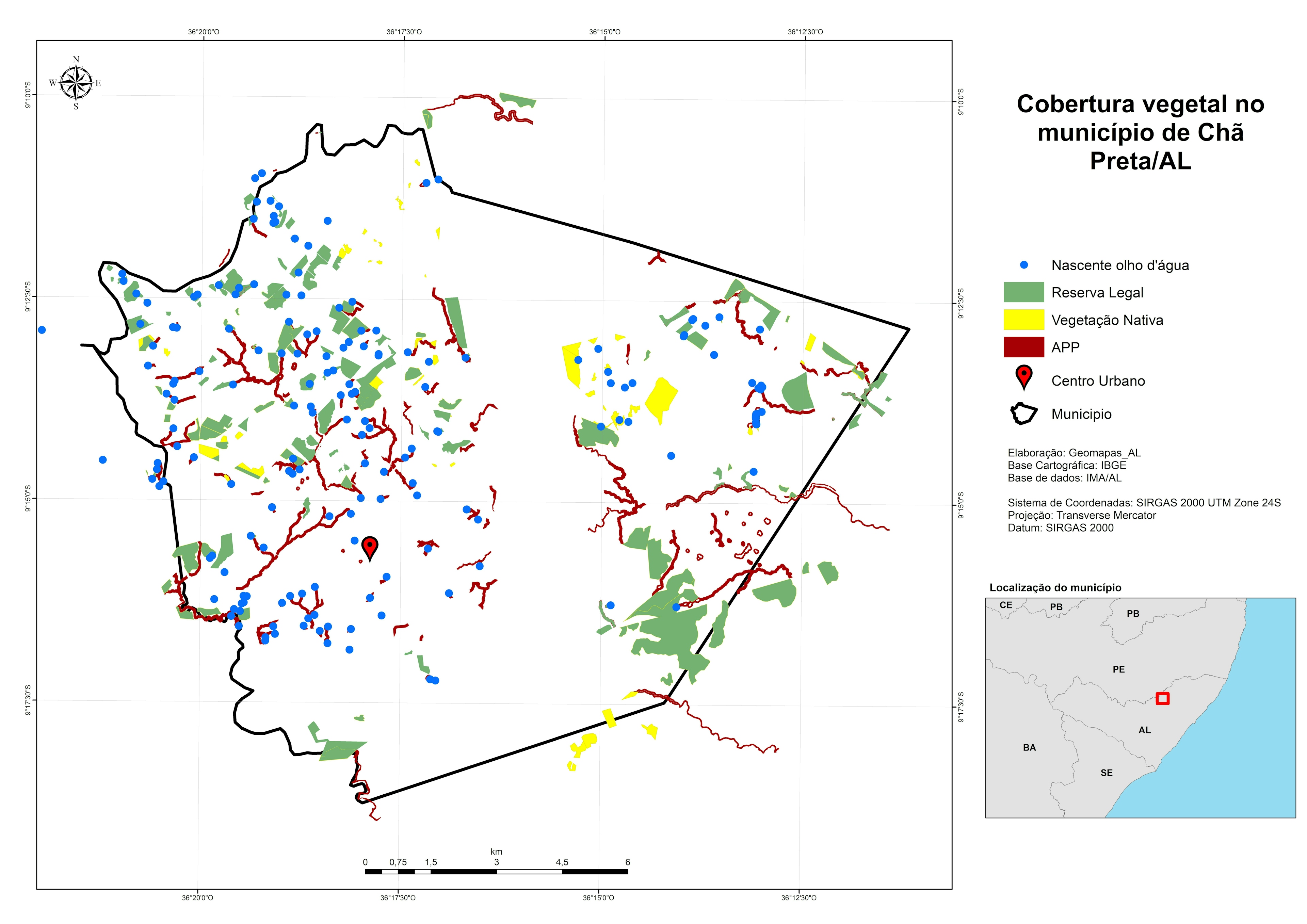
Relative river elevation model transformed from DEM data on USGS Lidar Explorer Map.


Plug-ins used

point sampling toolQchainage

tags

DEMGeospatialREMRemote Sensingriver

More by Matt Dempsey

Kootenai River REM
Kootenai River REM
17
Mississippi River REM
37

You might also like

Terrain and Viewshed Analysis
Yuxin (Sienna) He
Terrain and Viewshed Analysis
Yuxin (Sienna) He
25
Urban Agenda Canary Islands
Gerardo Ezequiel Martín Carreño
Urban Agenda Canary Islands
Gerardo Ezequiel...
49
Population Density Analysis
Farhan Towsif
Population Density Analysis
Farhan Towsif
3
Mapa de localização município de Lajes
Luana Moreira
Mapa de localização município de Lajes
Luana Moreira
62
2020 Rainfall Dashboard, Nigeria
Lawrence Akpoterai
2020 Rainfall Dashboard, Nigeria
Lawrence Akpoterai
240
Localização de um parque RPPN
Carla Américo
Localização de um parque RPPN
Carla Américo
2
School Mapping for Washington, DC.
Liam Patterson
School Mapping for Washington, DC.
Liam Patterson
28
Incidência de COVID-19 em SP - 22.04.21
Isabela Pires de Almeida
Incidência de COVID-19 em SP - 22.04.21
Isabela Pires...
276
Desmatamento na APA Chapada do Araripe
Luiz Prado
Desmatamento na APA Chapada do Araripe
Luiz Prado
198
Difference of votes between PNL/PSD (RO)
Ioana Zaharie
Difference of votes between PNL/PSD (RO)
Ioana Zaharie
13
Geologic Map for the Republic of Panama
Milton Solano Sequeira
Geologic Map for the Republic of Panama
Milton Solano Sequeira
386
A story map about Frenchy, my dog
All That Geo
A story map about Frenchy, my dog
All That Geo
170

Join the community!

We're a place where geospatial professionals showcase their works and discover opportunities.

Sign Up for free