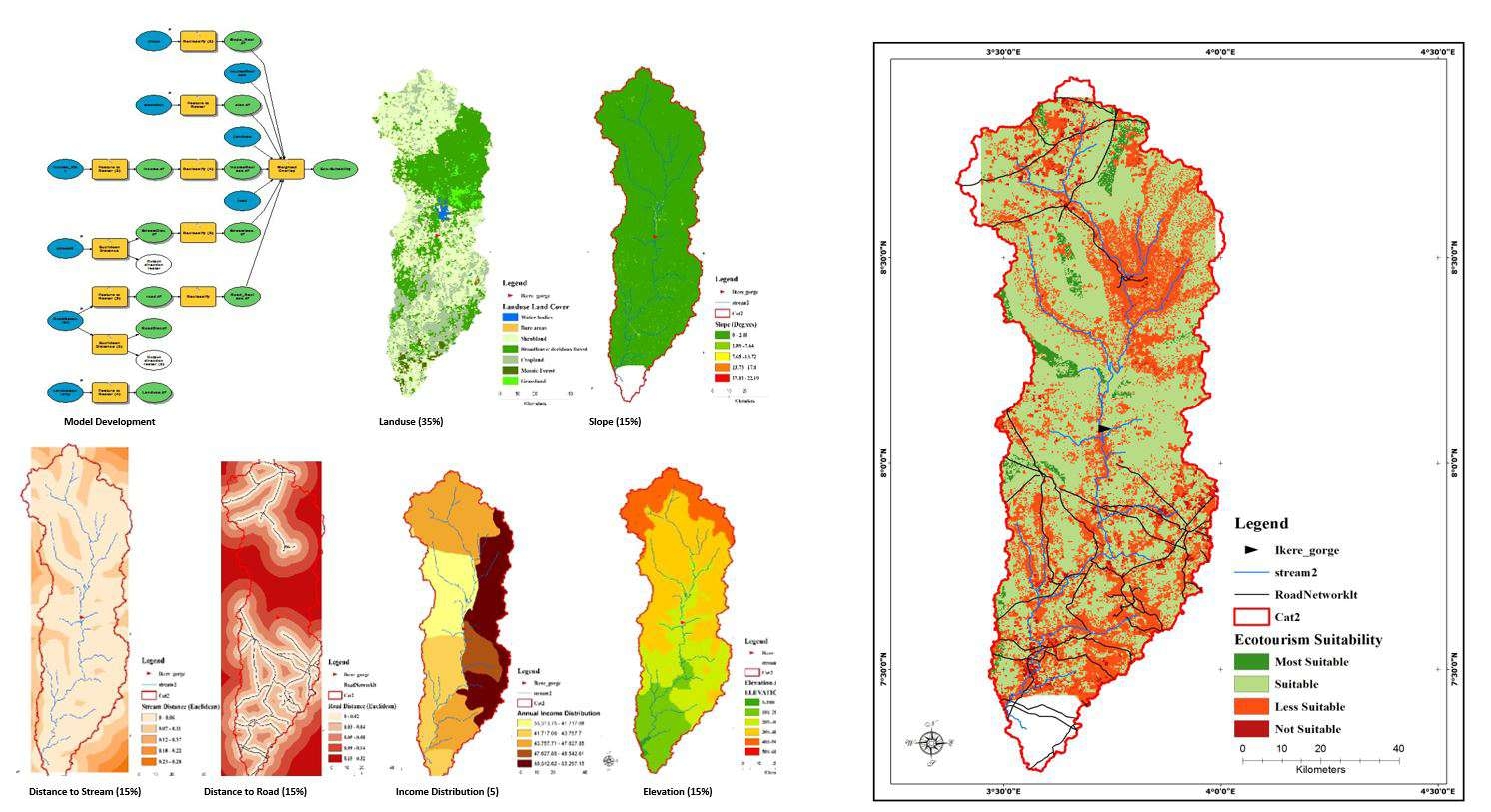
The full potential of remote sensing and GIS can be utilized when an integrated approach is adopted. Integration of the two technologies has proven to be an efficient tool in groundwater studies (Krishnamurthy et al., 1996). In models derived through the integration of various thematic maps using a GIS approach, several parameters are commonly involved to assess groundwater potential in Ijero-Ekiti, Nigeria. The modelling involves the delineation of zones of varying groundwater potential based on the integration of six thematic maps in a raster-based GIS. The six parameters considered are Soil, Geology, Land use/ Land Cover, Lineament, drainage and elevation. Every class in the thematic layers was placed into one of the following categories viz. (i) Good (iii) Moderate (iv) Poor, depending on their level of groundwater potential. Considering their behaviour with respect to groundwater control, the different classes were given suitable values, according to their importance relative to other classes in the same thematic layer.
The groundwater potential zones were obtained by overlaying all the thematic maps in terms of weighted overlay methods using the spatial analysis tool in ArcGIS 10.3. During the weighted overlay analysis, the ranking has been given for each individual parameter of each thematic map and the weightage was assigned according to the influence of the different parameters and was presented in Table 2. This weightage have been taken considering the works carried out by researchers such as Srinivasa & Jugran (2003), Krishnamurthy et al. (1996) Saraf & Choudhary (1998). All the thematic maps were converted into grid (raster format) and superimposed by the weighted overlay method (rank and weightage wise thematic maps and integrated with one another through GIS (Arc / Info grid environment). As per this analysis, the total weights of the final integrated grids were derived as the sum of the weights assigned to the different layers based on suitability (Environment System Research Institute Inc.’s ArcView GIS Software, 1997).
From the analysis carried out, results of the weighted overlay show that there are no areas of acutely high or low groundwater potential in the study area with moderate potentials of Groundwater obtainable from the study area. The spatial distribution of the various zones of groundwater potential obtained from the model generally shows regional patterns related to soils, drainage and geology, lineament and Land use patterns. The good zonal categories are along major lineaments and drainage channels with and without structural control, highlighting the importance of lineaments, and geological and soil units for groundwater investigations. Areas with moderate groundwater potential are attributed to combinations of lithology and landform. The poor categories of groundwater potential are distributed mainly along hills, ridges and pediments and to some extent along lineaments in the low to poor slope classes


.svg "Keran Nkongolo")