Sign up or log in to your Spatialnode account.

Takes less than a few seconds.

Landslide Risk Model Post-Palisades Fire

Piper Livingston
Piper Livingston•

May 31, 2025

Landslide Risk Model Post-Palisades Fire

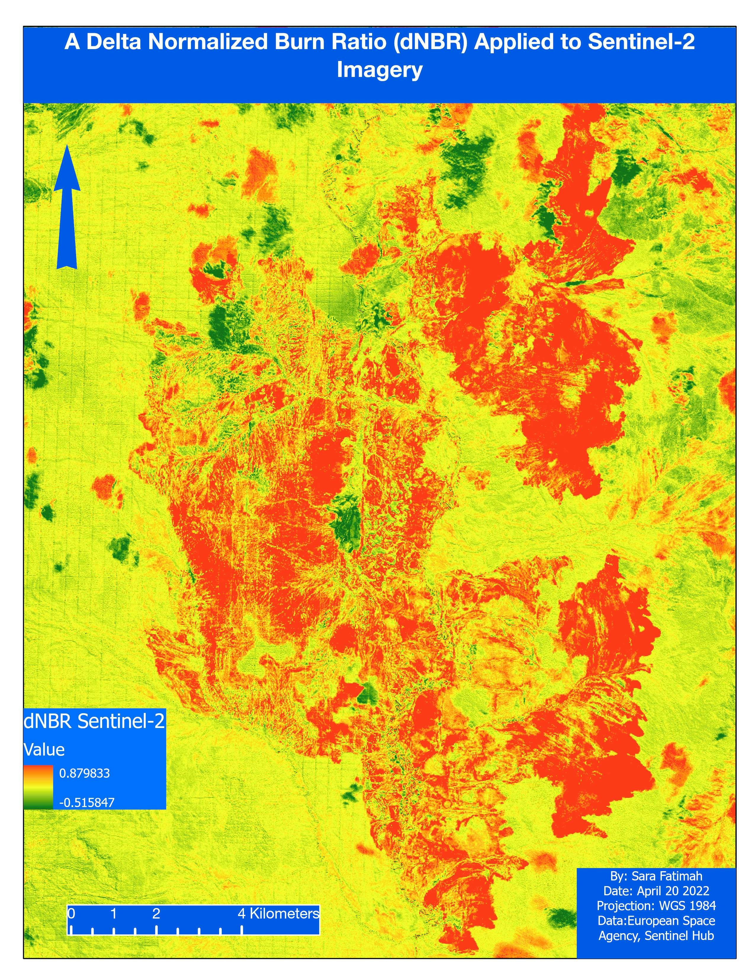
I used several workflows and methods to create a landslide risk model, including remote sensing processes and data analysis.


tags

Remote Sensing

You might also like

Map of Udi LGA in Enugu State, Nigeria
Chukwulobe Martins Ugonna
Map of Udi LGA in Enugu State, Nigeria
Chukwulobe Martins Ugonna
194
Mapa Hidrográfico – Rio Camarajipe
David
Mapa Hidrográfico – Rio Camarajipe
David
10
COVID19 Dashboard Fairfax VA
Bryan Smalley
COVID19 Dashboard Fairfax VA
Bryan Smalley
22
NorthStateGIS YouTube Videos
Naomi Yates
NorthStateGIS YouTube Videos
Naomi Yates
306
Relative Elevation Model (REM)
Adriana Calderon
Relative Elevation Model (REM)
Adriana Calderon
626
Região Geográfica Baependi-Caxambu - MG
Paulo Vitor Moraes Estella
Região Geográfica Baependi-Caxambu - MG
Paulo Vitor...
17
Built up areas of Asia
Ayeisha Sheldon
Built up areas of Asia
Ayeisha Sheldon
102
Mapa de focos de Queimadas do Piauí
RONEIDE DOS SANTOS SOUSA
Mapa de focos de Queimadas do Piauí
RONEIDE DOS...
44
Municipality of Thessaloniki - 3D Vis
Efstathios Lymperis
Municipality of Thessaloniki - 3D Vis
Efstathios Lymperis
84
Lidar in ArcScene #30DayMapChallenge #Day11 #3D
Marcelo Aguilera
Lidar in ArcScene #30DayMapChallenge #Day11 #3D
Marcelo Aguilera
796
Fire Station Response Time
Niroj Shrestha
Fire Station Response Time
Niroj Shrestha
41
Power Bi DashBoard Mock Up
Jesse Kato
Power Bi DashBoard Mock Up
Jesse Kato
266

Join the community!

We're a place where geospatial professionals showcase their works and discover opportunities.

Sign Up for free