Sign up or log in to your Spatialnode account.

Takes less than a few seconds.

Missouri Impaired Lakes

Keran Nkongolo
Keran Nkongolo•

February 13, 2024

Missouri Impaired Lakes

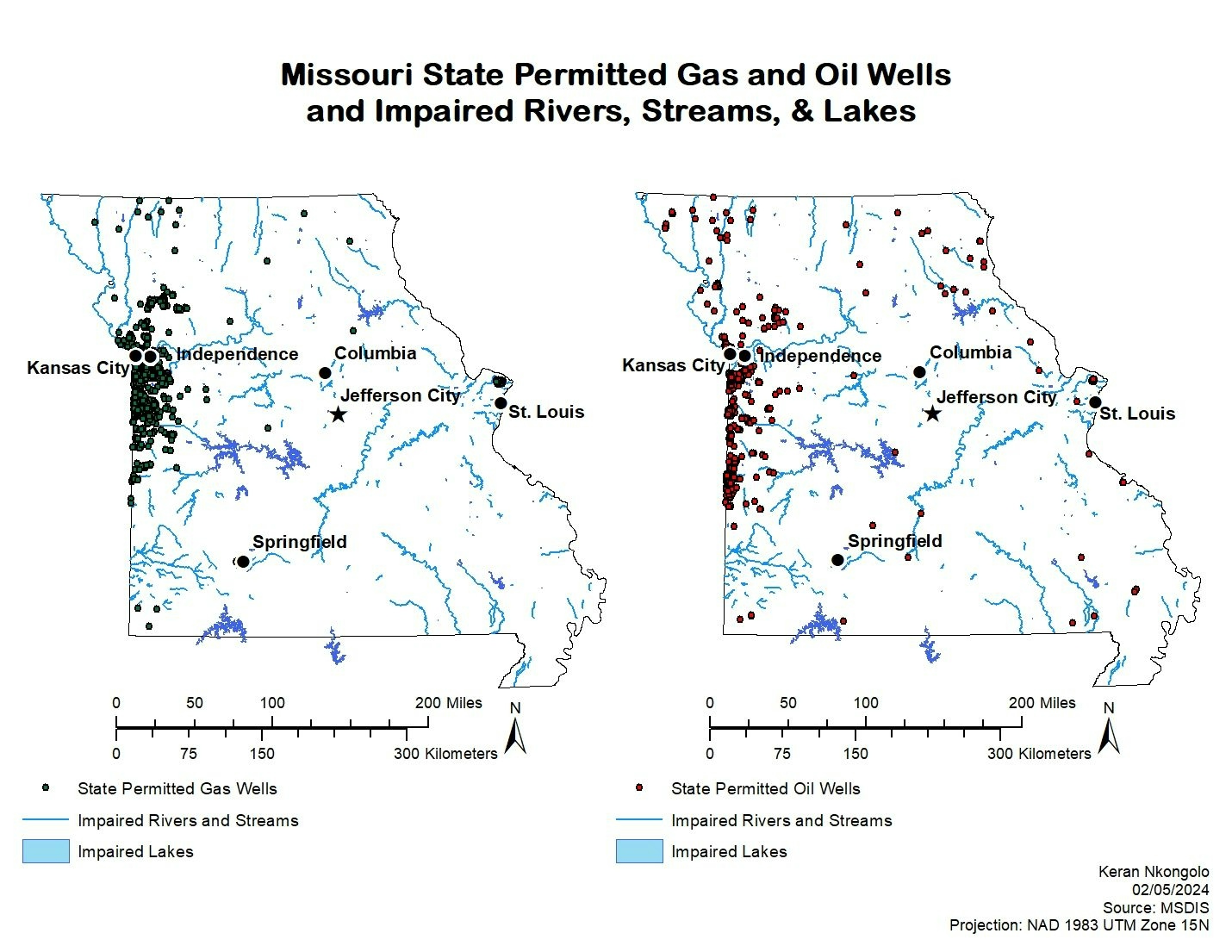
This project investigates the potential relationship between oil and gas wells in Missouri along with impaired rivers streams and lakes.


Plug-ins used

ArcMap

tags

ArcMap

More by Keran Nkongolo

Springfield Sinkholes
137
Utah Farms OLS Regression
18
Idaho Wells and Lead Mines
8
Utah Farms
Utah Farms
24
MN Groundwater Contamination
9
Utah Farms GWR Regression
12
2023 WY Pastureland & OLS Regression
17
CA Acres Burned & OLS Regression 2019
25
Maine Pollutant Discharge
21
CA Acres Burned and Wildfires
18
Santa Fe Supervised Classification
24
CA Average Temperature & WF
16

You might also like

Mapa Cadastro Ambiental Rural CAR
Fabio Rodrigo Aliberti
Mapa Cadastro Ambiental Rural CAR
Fabio Rodrigo Aliberti
566
2019 Landcover Northern Colorado
Sara Fatimah
2019 Landcover Northern Colorado
Sara Fatimah
50
Diorama 3D - Crater Lake
Pedro Ferreira
Diorama 3D - Crater Lake
Pedro Ferreira
145
Historical UFO Sightings - USA
Cole Feyen
Historical UFO Sightings - USA
Cole Feyen
18
Mapa de Uso e Ocupação do solo
José Luiz Anjos
Mapa de Uso e Ocupação do solo
José Luiz Anjos
204
Erosion Susceptibility Modelling
Christina Nedo
Erosion Susceptibility Modelling
Christina Nedo
41
Mapa de Localização
Lucas de Siqueira Cardinelli
Mapa de Localização
Lucas de...
34
jj
Luana Lavagnoli Moreira
jj
Luana Lavagnoli Moreira
13
Model Builder
Matthew Tomitz
Model Builder
Matthew Tomitz
29
Street Guide Map of Okirika Main Town
Comson Iyamisigh
Street Guide Map of Okirika Main Town
Comson Iyamisigh
24
GPS Interval Dataset visualization
alyle5@charlotte.edu
GPS Interval Dataset visualization
alyle5@charlotte.edu
20
DPA DAS COMUNAS DO ZAÍRE
Raduel Fernando da Fonseca
DPA DAS COMUNAS DO ZAÍRE
Raduel Fernando...
47

Join the community!

We're a place where geospatial professionals showcase their works and discover opportunities.

Sign Up for free