Sign up or log in to your Spatialnode account.

Takes less than a few seconds.

Rwanda - Color map (Matching villages)

Jose Rubio-Valverde
Jose Rubio-Valverde•

July 22, 2022

Rwanda - Color map (Matching villages)

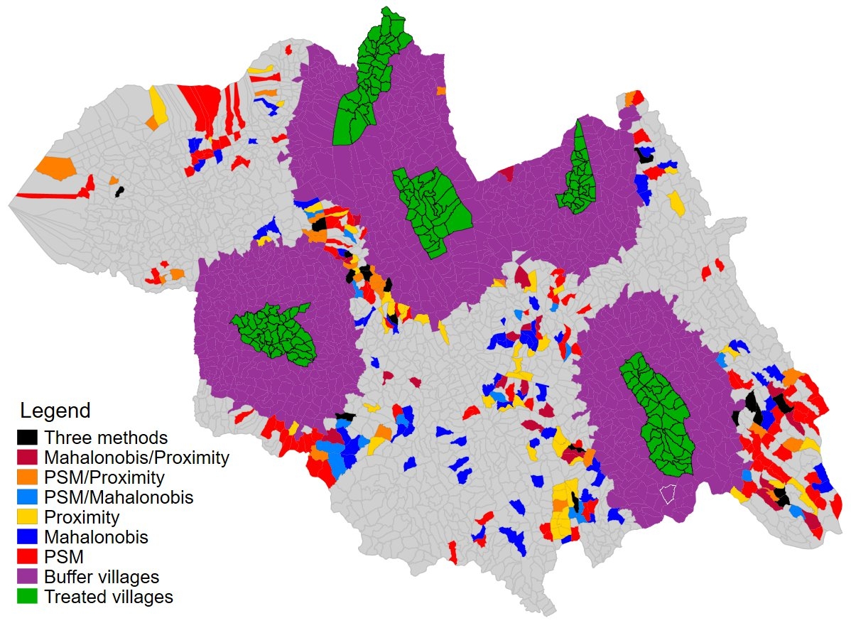
Northern province of Rwanda showing matches for treated villages using different methodologies. Data used for matching is geospatial layers.


More by Jose Rubio-Valverde

Population  (Rwanda- Northern Province)
Population (Rwanda- Northern Province)
133
Skilled birth(Rwanda -Northern province)
81
Rwanda - Northern Province by village
142

You might also like

Population Density Map - Japan
Cole Feyen
Population Density Map - Japan
Cole Feyen
26
EzeAni Groundwater Quality
Emeka Ude
EzeAni Groundwater Quality
Emeka Ude
46
Average Electricity Access Rural Areas
Jonathan Correa Varela
Average Electricity Access Rural Areas
Jonathan Correa Varela
14
MAPA DE LOCALIZAÇÃO MONTE AZUL-MG
Fenando Paulo Neto Alberto
MAPA DE LOCALIZAÇÃO MONTE AZUL-MG
Fenando Paulo...
498
St. Joe County Contours
Seth Frame
St. Joe County Contours
Seth Frame
93
Image Classification of Habitat Elements
Ali Mulla
Image Classification of Habitat Elements
Ali Mulla
19
Lajeado and Estrela river location
Vinicius Kuchinski
Lajeado and Estrela river location
Vinicius Kuchinski
104
Bacias e Hidrografia Unifilar (PE)
Luan Tomaz
Bacias e Hidrografia Unifilar (PE)
Luan Tomaz
74
Análise com dados do IBGE
Carlos Joubert Sousa da Rocha
Análise com dados do IBGE
Carlos Joubert...
202
Inventário Florestal de Belo Horizonte
Ana Paula Dias Pena
Inventário Florestal de Belo Horizonte
Ana Paula...
58
Estimating Timber Volume with LIDAR
Moez Labiadh
Estimating Timber Volume with LIDAR
Moez Labiadh
1.5K
LOCALIZAÇÃO DO MUNICÍPIO DE PARANAVAÍ-PR
Itamar Sateles de Sá
LOCALIZAÇÃO DO MUNICÍPIO DE PARANAVAÍ-PR
Itamar Sateles...
611

Join the community!

We're a place where geospatial professionals showcase their works and discover opportunities.

Sign Up for free