.jpg&w=3840&q=100)
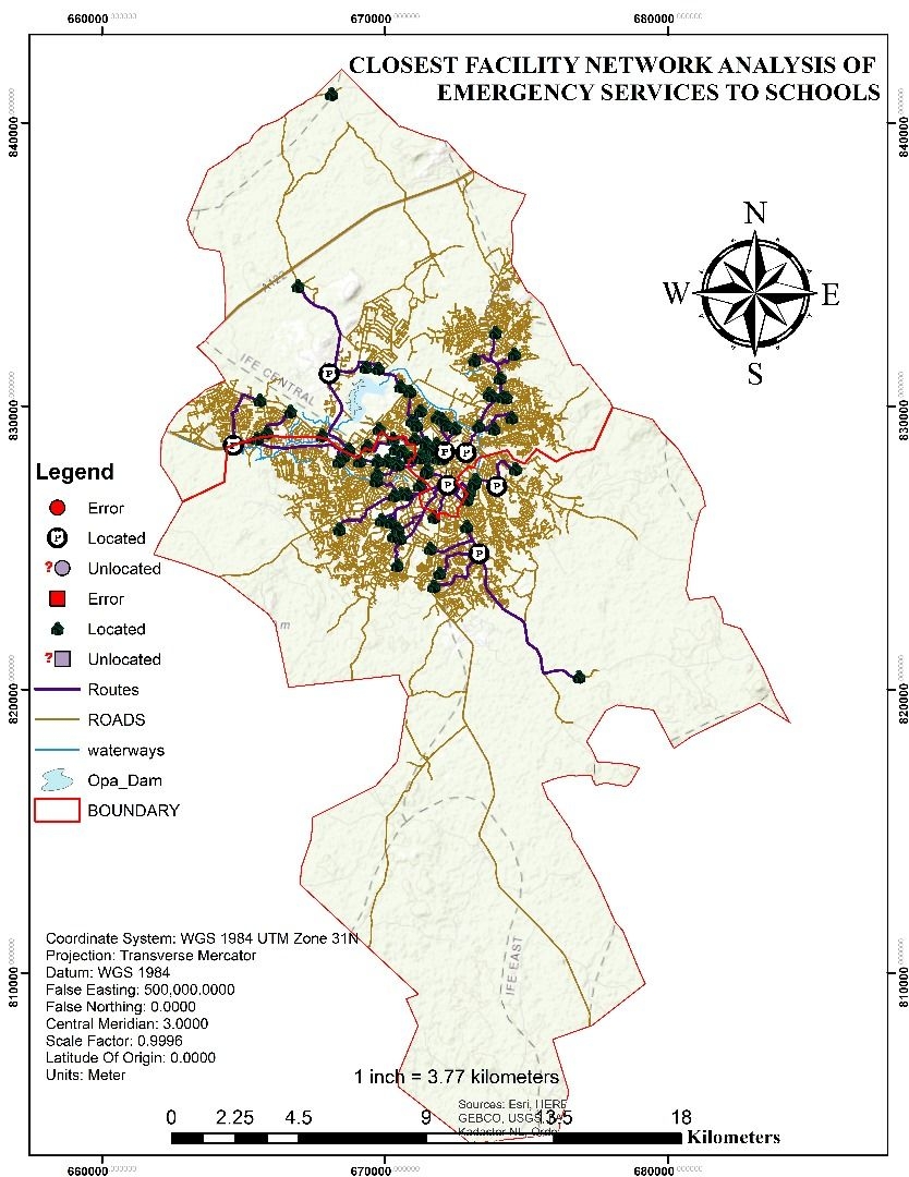
🧾 Summary: Windmills are great because they use wind to make energy without pollution, helping the environment and saving resources. For this project, three potential sites (Site 1: South of Wentworth house, Site 2: North of Dunebrook, and Site 3: South of Bradfield Environmental University, Sheffield) were Identified for siting a new windmill.
Site 1, 2 and 3 are situated to the north, south and central part of the study area, respectively. Both locations are situated on the outskirts of Sheffield, surrounded by countryside characterized by fewer residential developments and expansive grazing farmlands, minimizing disturbances to residential areas. Moreover, both sites enjoy close proximity to open grazing farmlands. Despite being in remote farmland areas, these locations offer optimal wind conditions ideal for efficient energy generation. While service access may be less convenient compared to urban areas, the advantages of reduced costs, minimal noise impact, and favorable wind conditions far outweigh any potential drawbacks.
🔍 Data Collection: Some of the dataset used includes: the OS Terrain 5 DTM (Digital terrain model) provided by @Ordnance Survey, Boundary layers for Site of specific scientific Interests were provided by Natural England Open Data in collaboration with @ESRI.
💻 Processing & Analysis: I utilized ArcGIS Desktop to process, analyze, and visualize data, focusing on factors like elevation, slope, aspect, proximity to residential areas, and distance to specific sites. While these are crucial, I also considered other factors influencing energy optimization. Through weighted overlay analysis, I assigned different weightings to each criterion, then categorized the output layer into three classes for clear interpretation.
📈 Visualization: Static maps were generated to visualize the suitability classes (unsuitable, fairly suitable and suitable), the potential sites for siting new windmills and also the SSSI boundary layers.


.png&w=3840&q=100)