Sign up or log in to your Spatialnode account.

Takes less than a few seconds.

Digitalization of roads - New Guinea

Martin Nuñez Igarzabal
Martin Nuñez Igarzabal•

May 08, 2023

Digitalization of roads - New Guinea

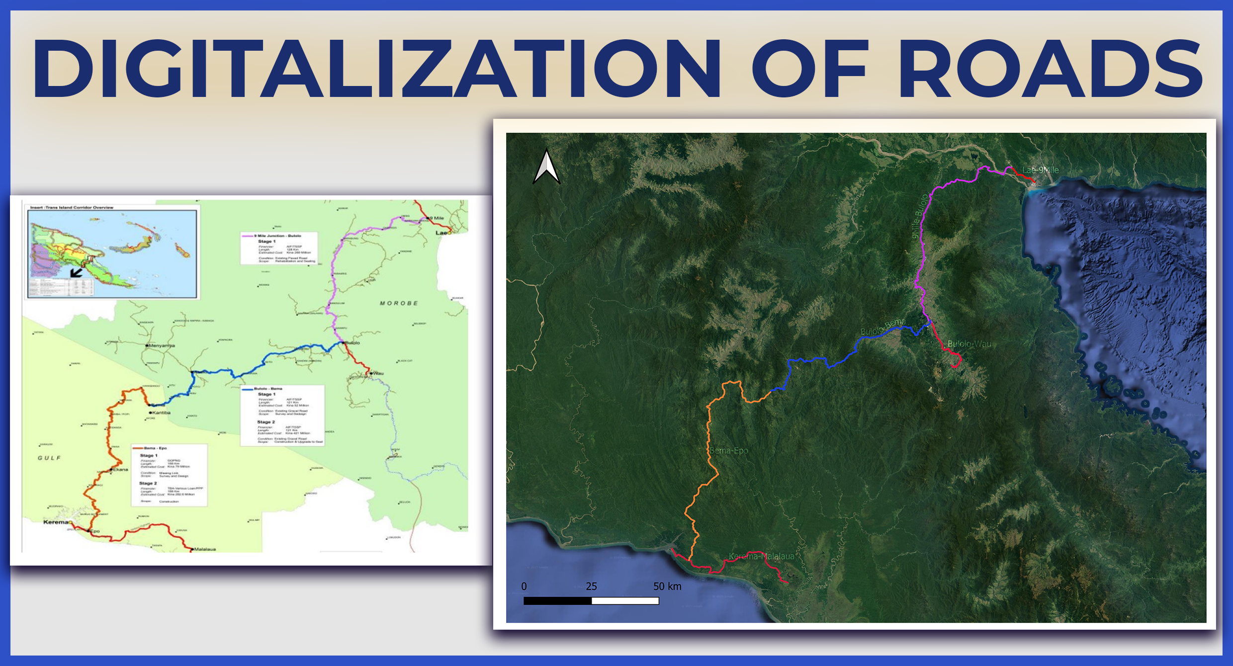
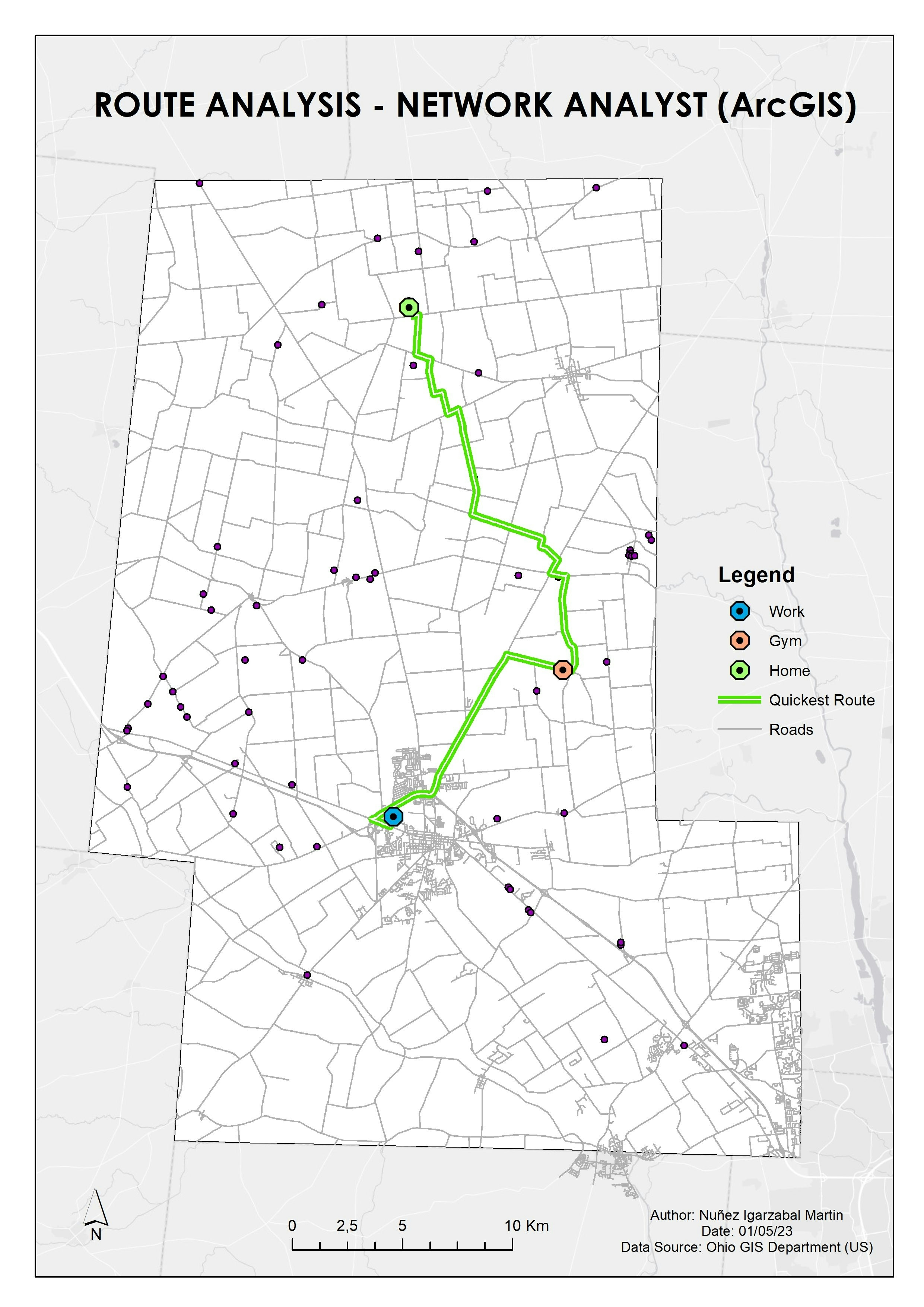
Digitalization of roads from raster image using QGIS.


Tools used

QGISRemote Sensing

Plug-ins used

georeferencer

tags

digital image processingdigitising

More by Martin Nuñez Igarzabal

Voting data in California
19
Geological Map Digitalization
5
Digital Elevation Model - Buenos Aires
60
Population Heat Map - Arkansas
36
QGIS Map (Southern Europe)
42
Route Analysis (ArcGIS Network Analyst)
16
Population Density Map of Arkansas
47
Infographic Map - Mining Company
9
ArcGIS Map (Ozone concentration)
14
Drive Time Areas Map
9
Temperature Heat Map - Argentina
30
Spatial Analysis - Drive time (QGIS Map)
16

You might also like

Mapa de estudo  ambiental
Paulo Ricardo Gomes de Souza
Mapa de estudo ambiental
Paulo Ricardo...
168
Modelo Digital de Elevação - Alto Iguaçu
DOUGLAS HENRIQUE MANOEL PEREIRA
Modelo Digital de Elevação - Alto Iguaçu
DOUGLAS HENRIQUE...
12
Mapa de Reflorestamento - APA Jaceruba
Williane de Vasconcelos Meneses
Mapa de Reflorestamento - APA Jaceruba
Williane de...
39
3D Forested Ski Resort
Ryan Shields
3D Forested Ski Resort
Ryan Shields
17
Oregon Groundwater & Abandoned Mines
Keran Nkongolo
Oregon Groundwater & Abandoned Mines
Keran NkongoloPro
17
Poverty and Food Access in LA County
Whitney
Poverty and Food Access in LA County
Whitney
22
Finding underperforming retail markets
Matthew Forrest
Finding underperforming retail markets
Matthew Forrest
855
Portfolio of Certification Projects
Travis Leverenz
Portfolio of Certification Projects
Travis Leverenz
2
Study Area & Black Bear Habitat
Sara Fatimah
Study Area & Black Bear Habitat
Sara Fatimah
21
Mapa de Classes de Declive
Luiz Gustavo De Góes Sterle
Mapa de Classes de Declive
Luiz Gustavo...
38
Hurricanes since 1851
Lukumon Lateef
Hurricanes since 1851
Lukumon Lateef
15
Rank de Felicidade Mundial (2015-2017)
Henrique Pinheiro de Souza
Rank de Felicidade Mundial (2015-2017)
Henrique Pinheiro...
15

Join the community!

We're a place where geospatial professionals showcase their works and discover opportunities.

Sign Up for free