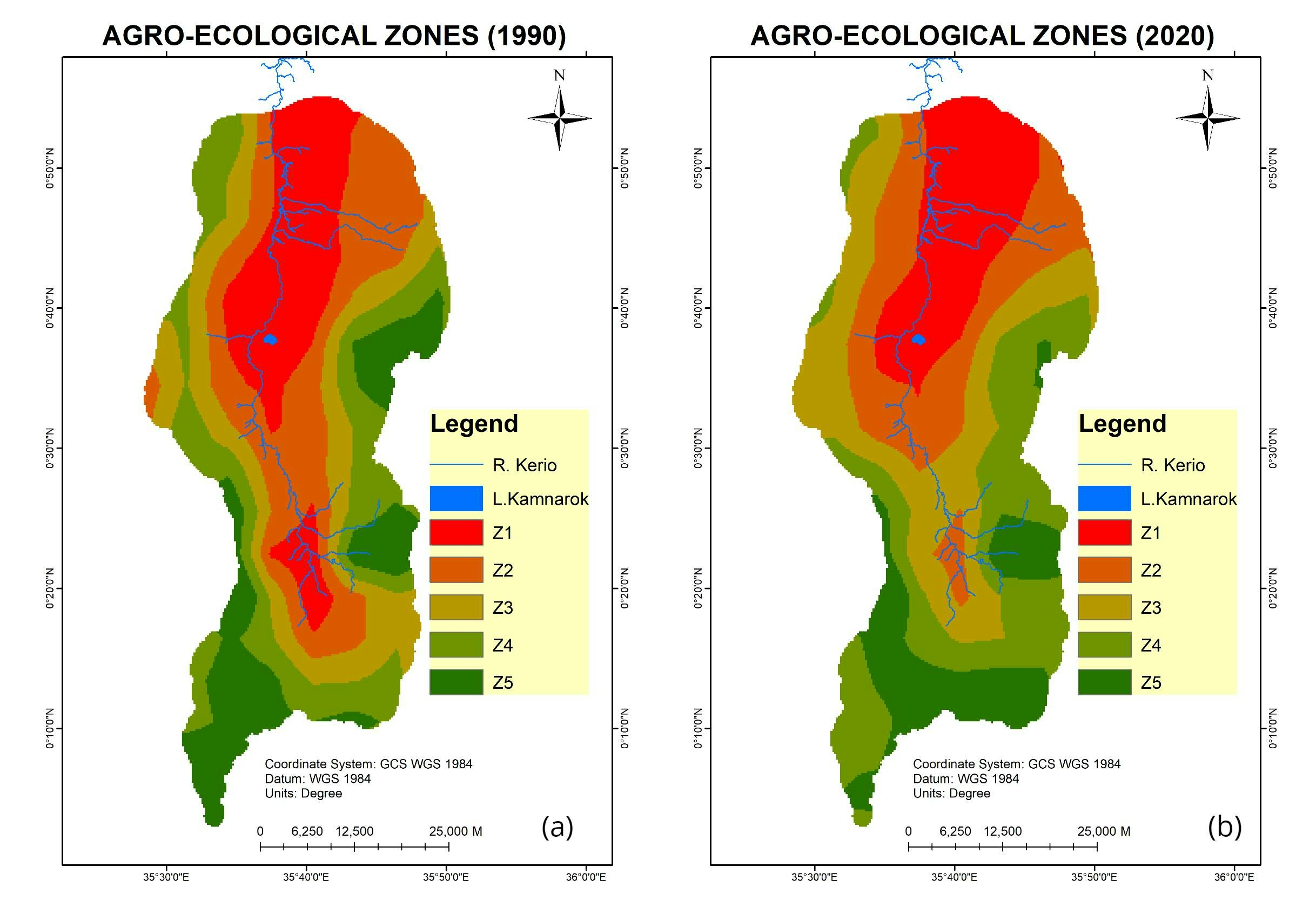
Sign up or log in to your Spatialnode account.

Takes less than a few seconds.

KERIO VALLEY AGROECOLOGICAL ZONES, Kenya

John Wahome Gathoni
John Wahome Gathoni•

January 31, 2022

KERIO VALLEY AGROECOLOGICAL ZONES, Kenya
  • Z1 - Lowlands
  • Z2 - Upper Lowlands
  • Z3 - Lower Midlands
  • Z4 - Upper Midlands
  • Z5 - Highlands


Tools used

ArcMapQGIS

Plug-ins used

Spatial analyst

tags

ArcMapQGIS

More by John Wahome Gathoni

Health Centres in Kenya
18
GEOHAZARD RISK ZONES ANALYSIS
97
KENYA ESRI LULC 2020
107
KERIO VALLEY SOIL LOSS USING RUSLE
95
Soil and water conservation Suitability
65
TANYAI FOREST LOSS ANALYSIS(1990-2020)
140
Mombasa Tourist Guiding System
320
BARINGO COUNTY PROPOSED CONSERVANCIES
91
Monochrome Map
Monochrome Map
11
Find the Nearest Health Centre
21
UHURU PARK LOCATION-NAIROBI, KENYA
60

You might also like

Classification of Tehama County, CA fire
Cole Feyen
Classification of Tehama County, CA fire
Cole Feyen
11
Sistema Viário RMBH
Emanuel Sanches
Sistema Viário RMBH
Emanuel Sanches
37
Mapa de Localização em carta
Thátila de Jesus Assis
Mapa de Localização em carta
Thátila de...
5
Rendimento por zonas em Itabirito-MG
Emanuel Sanches
Rendimento por zonas em Itabirito-MG
Emanuel Sanches
11
Inventário Nacional de Emissões de GEE
Augusto Fernandes
Inventário Nacional de Emissões de GEE
Augusto Fernandes
15
City of Fife Annexation History
Rhonda Parrish, GISP
City of Fife Annexation History
Rhonda Parrish, GISP
11
Geo-app: new and pending land divisions
Sherri Michl
Geo-app: new and pending land divisions
Sherri Michl
195
Population Heat Map - Arkansas
Martin Nuñez Igarzabal
Population Heat Map - Arkansas
Martin Nuñez Igarzabal
41
Different way to see world
Vitória Serra Bernardes
Different way to see world
Vitória Serra Bernardes
164
Vardar River REM
Efstathios Lymperis
Vardar River REM
Efstathios Lymperis
40
Modelo Digital de Elevação - Alto Iguaçu
DOUGLAS HENRIQUE MANOEL PEREIRA
Modelo Digital de Elevação - Alto Iguaçu
DOUGLAS HENRIQUE...
14
Flood Mapping of Ibadan Metropolis
Adewale Olayemi
Flood Mapping of Ibadan Metropolis
Adewale Olayemi
644

Join the community!

We're a place where geospatial professionals showcase their works and discover opportunities.

Sign Up for free