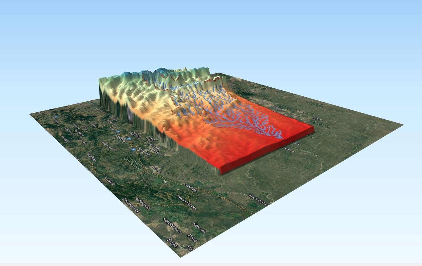
Introduction: This report documents a comprehensive endeavor in 3D data visualization and analysis conducted for the Sabie Basin in South Africa. Leveraging the powerful capabilities of QGIS, specifically the 'QuickMapServices' and 'Qgis2threejs' plugins, this project aimed to generate a detailed 3D elevation model of the watershed basin. The integration of these plugins facilitated an immersive exploration of the terrain, offering valuable insights for environmental assessment and resource management.
Project Overview:
Data Acquisition:
The project commenced with the acquisition of relevant geospatial data, including elevation data, land cover information, and hydrological features specific to the Sabie Basin. These datasets formed the foundation for the subsequent 3D visualization and analysis.
QuickMapServices Plugin:
The 'QuickMapServices' plugin in QGIS was instrumental in accessing base maps and satellite imagery, providing a contextual backdrop for the 3D visualization. This plugin streamlined the process of incorporating high-quality and up-to-date map services into the project.
Elevation Model Generation:
Leveraging elevation data, the 'Qgis2threejs' plugin was employed to generate a 3D elevation model of the Sabie Basin. This dynamic visualization tool enabled the transformation of traditional 2D maps into interactive 3D representations, enhancing the understanding of the terrain.
Terrain Analysis:
The 3D elevation model facilitated a detailed terrain analysis of the Sabie Basin, allowing for the identification of key topographic features, such as ridges, valleys, and elevation gradients. This analysis provided valuable insights into the geomorphological characteristics of the watershed.
Hydrological Assessment:
Hydrological features, including rivers, tributaries, and drainage patterns, were visually assessed in 3D. This aspect of the analysis contributed to a better understanding of the watershed's hydrological dynamics and the potential impact on water flow and distribution.
Environmental Visualization:
The project aimed to enhance environmental visualization by representing land cover and land use patterns in 3D. This holistic approach provided a more immersive perspective on the interaction between natural and anthropogenic elements within the Sabie Basin.
Benefits and Significance:
Enhanced Spatial Understanding:
The 3D visualization of the Sabie Basin offered stakeholders an enhanced spatial understanding of the terrain, fostering better-informed decision-making in environmental planning and management.
Interactive Exploration:
The interactive nature of the 3D elevation model allowed users to explore the Sabie Basin dynamically, zooming in on specific features and gaining a nuanced perspective of the landscape.
Effective Communication:
The visual representation of terrain and hydrological features in 3D facilitated effective communication of complex geographic information, making it accessible to a wider audience, including policymakers, researchers, and local communities.
Conclusion: The successful execution of 3D data visualization and analysis for the Sabie Basin using QGIS, with the aid of the 'QuickMapServices' and 'Qgis2threejs' plugins, represents a significant advancement in the field of geospatial analysis. The project not only demonstrated the versatility of QGIS in handling complex spatial data but also underscored the potential for 3D visualization tools to enhance the understanding of watershed dynamics for informed environmental decision-making.
Keywords: QGIS, 3D Data Visualization, Sabie Basin, South Africa, QuickMapServices, Qgis2threejs, Elevation Model, Terrain Analysis


.svg "Keran Nkongolo")


_645201.jpg&w=48&q=40 "Eguagie-suyi Precious")