Introduction:
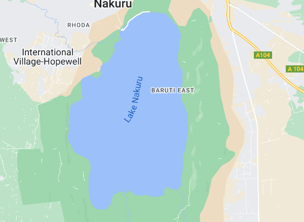
This report outlines a project focused on the analysis of Lake Nakuru utilizing Landsat 8 imagery and the computation of the Normalized Difference Water Index (NDWI). The primary objective of this endeavor is to gain insights into the water dynamics of Lake Nakuru over a specific time frame, employing the robust capabilities of Google Earth Engine.
Data Acquisition:
The Landsat 8 imagery for Lake Nakuru was sourced through the Google Earth Engine platform. Rigorous filtering was applied, considering the geographical bounds, a temporal range from January 1, 2015, to June 30, 2023, and a stringent cloud cover threshold of less than 1%. This meticulous data curation ensures the reliability and accuracy of the subsequent analysis.
NDWI Computation:
Two specific bands, B3 and B5, were carefully selected from the Landsat imagery as they are instrumental in computing the NDWI. The NDWI formula, a normalized difference approach, was implemented through a custom function. This function was then applied to the selected bands, resulting in the integration of the NDWI as an additional band in the image dataset.
Results and Visualization:
The script concludes by presenting a comprehensive overview of the results. This includes the initial Landsat image, the selected bands, the NDWI-calculated image, and a standalone NDWI layer. These visualizations provide a nuanced understanding of the water dynamics within Lake Nakuru, enhancing our ability to monitor changes over time.
Significance of the Project:
The significance of this project lies in its ability to leverage advanced geospatial technologies to monitor and analyze water dynamics in Lake Nakuru. The NDWI serves as a powerful indicator of changes in water bodies, with applications ranging from ecological studies to water resource management. Understanding these dynamics is crucial for environmental stewardship, enabling informed decision-making for sustainable development, habitat conservation, and potentially even early detection of environmental stressors.
In summary, this project showcases the practical application of remote sensing and geospatial analysis in monitoring and understanding water bodies. The insights derived from the NDWI analysis contribute to our broader understanding of Lake Nakuru's ecosystem, aligning with the broader goals of environmental conservation and sustainable resource management.
https://code.earthengine.google.com/ba62e3dc8c9ed9bf0d7f363c70d19041