This comprehensive geospatial project leveraged the capabilities of the Google Earth Engine (GEE) platform to conduct a thorough analysis of rainfall deviations in Machakos County. The project commenced with the importation of the county's shapefile into GEE, showcasing the integration of geospatial data into the GEE environment.
For data analysis, the project utilized CHIRPS data, an acronym for Climate Hazards Group InfraRed Precipitation with Station data. CHIRPS integrates satellite imagery with ground-based station readings, providing a robust dataset for accurate information about rainfall. This dataset's high-level nature allows for detailed breakdowns into daily or five-day intervals, offering valuable insights into historical and recent rainfall trends.
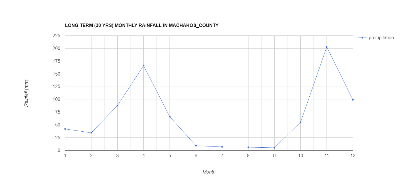
The workflow involves several critical steps, including calculating rainfall deviations for the year 2022, determining long-term rainfall averages over 30 years, and assessing seasonal variations. The project also delves into sub-county level analysis, aiming to identify localized rainfall deviations and their spatial distribution within Machakos County.
A significant part of the project showcases the integration of GEE with ArcGIS, a prominent geographic information system (GIS) software. The final stages involve importing rainfall deviation data from GEE into ArcGIS, using tools like "Extraction by Mask," "Inverse Distance Weighting (IDW)," and "Clipping" to enhance the analysis and visualization. The combination of GEE and ArcGIS provides a powerful synergy for handling complex geospatial data.
The project concludes with a final digital map, emphasizing the spatial variability of rainfall deviations across Machakos County. This map is the result of a \ process involving interpolation points, visualization parameters, and the Inverse Distance Weighting (IDW) interpolation method within ArcGIS. The final map, color-coded to represent rainfall anomalies, contributes to a comprehensive understanding of how precipitation patterns vary across the region.
The outcomes of the project include insights into spatial and temporal variability of rainfall deviations, identification of vulnerable areas, and recommendations for enhanced monitoring systems, localized mitigation strategies, climate-resilient agriculture, community awareness, and policy integration. The successful integration of GEE and ArcGIS is highlighted as a key aspect of the project's effectiveness, demonstrating the potential of these platforms in addressing complex geospatial challenges.
https://code.earthengine.google.com/45168f40bcbe7444485b22665d1209cc
https://code.earthengine.google.com/d86f9f5e8ec7af6a1367efb2bc79405e
https://code.earthengine.google.com/51586f487f5697cdaccd107f09c6196a