Sign up or log in to your Spatialnode account.

Takes less than a few seconds.

Nigerian State Map by Geozone

Samuel Eyo
Samuel Eyo•

July 24, 2025

Nigerian State Map by Geozone

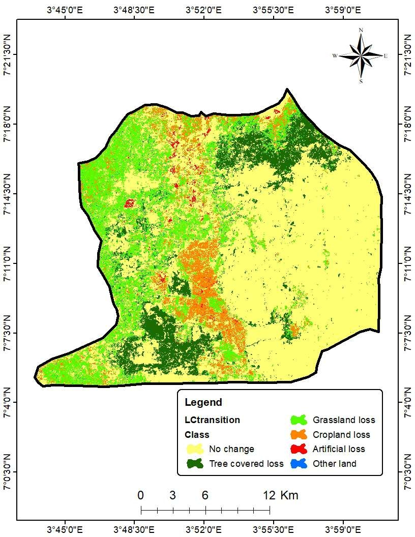
This is a Geozone map of Nigeria State. Nigeria have 36 States include the FCT and this State have been categorised based on their various Geozone.


tags

Symbology

More by Samuel Eyo

Bauchi Health Facility Distribution
4
Nigerian State Population Map
5
BBBike extract for gwarimpa Abuja
3
Bauchi State Map
Bauchi State Map
2
Bauchi Health Distribution and Access
6

You might also like

Mapa de Densidade demográfica
Mauricio Matheus
Mapa de Densidade demográfica
Mauricio Matheus
14
Densidade Demográfica
Sidney dos Santos
Densidade Demográfica
Sidney dos Santos
5
Population without a Vehicle
Whitney
Population without a Vehicle
Whitney
9
South Sound 911 Event Data Dashboard
Rhonda Parrish, GISP
South Sound 911 Event Data Dashboard
Rhonda Parrish, GISP
14
Série Temporal NDVI - Região Alfenas, MG
Paulo Vitor Moraes Estella
Série Temporal NDVI - Região Alfenas, MG
Paulo Vitor...
24
Registered EV Owners
Adam O Dolce
Registered EV Owners
Adam O Dolce
90
Mapa Demográfico de Angola
Fenando Paulo Neto Alberto
Mapa Demográfico de Angola
Fenando Paulo...
608
IdahoDarkRoads
Michael Nau
IdahoDarkRoads
Michael Nau
42
Elevation Map Switzerland Tanaka Method
Viola Schweiger
Elevation Map Switzerland Tanaka Method
Viola Schweiger
56
Mapa Avançado
Anmoran Cardoso Martins
Mapa Avançado
Anmoran Cardoso Martins
32
Mapa Vintage
jucelino dos santos
Mapa Vintage
jucelino dos santos
11
Classification of Tehama County, CA fire
Cole Feyen
Classification of Tehama County, CA fire
Cole Feyen
10

Join the community!

We're a place where geospatial professionals showcase their works and discover opportunities.

Sign Up for free