Sign up or log in to your Spatialnode account.

Takes less than a few seconds.

Population classification of Laos

Oswald Geospatial analyst
Oswald Geospatial analyst•

September 30, 2023

Population classification of Laos

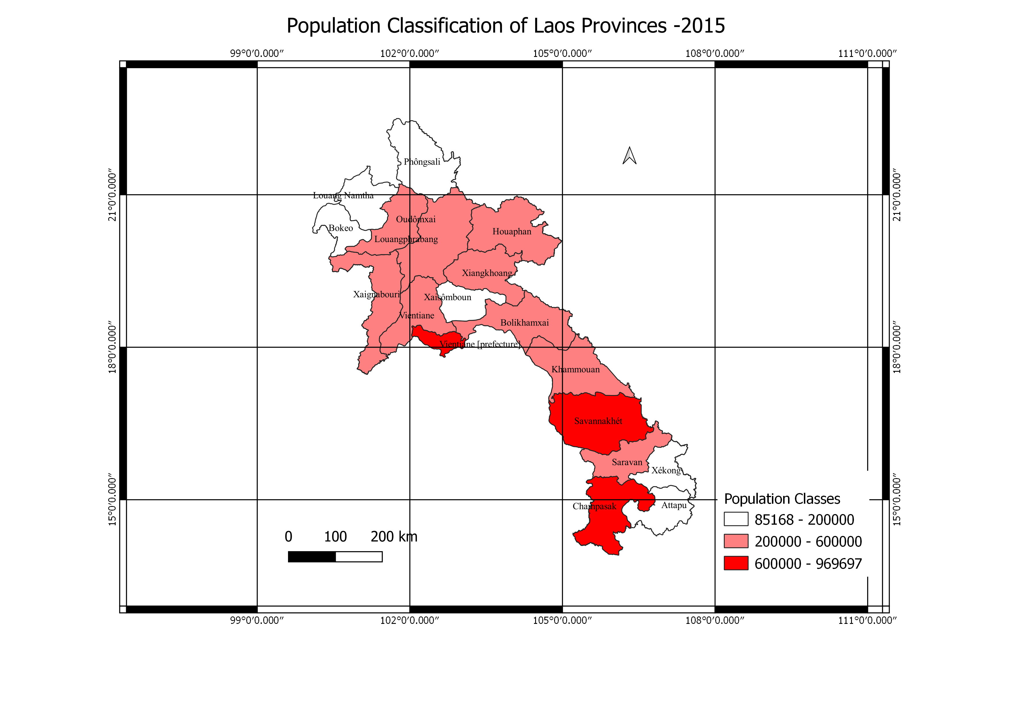
Visualization of the different classes of population in Laos Province


Plug-ins used

QGIS

tags

PopulationDensityQGISSpatial Data Science visualization

More by Oswald Geospatial analyst

Voters Participation map
13
3D model of part of Nigeria
13

You might also like

KERIO VALLEY SOIL LOSS USING RUSLE
John Wahome Gathoni
KERIO VALLEY SOIL LOSS USING RUSLE
John Wahome Gathoni
96
Power BI Drill Down Exercise
Jesse Kato
Power BI Drill Down Exercise
Jesse Kato
120
Diretrizes de altimetria #02
Isabel Freitas Aniceto
Diretrizes de altimetria #02
Isabel Freitas Aniceto
13
Rivers by Municipality
Marcelo Aguilera
Rivers by Municipality
Marcelo Aguilera
269
Spatial Regression for Canopy Cover Mich
Joe Pitti
Spatial Regression for Canopy Cover Mich
Joe Pitti
22
Uranium mines in Niger (2021)
Guy-Arnaud Puthomme
Uranium mines in Niger (2021)
Guy-Arnaud Puthomme
16
Flood Hazard Mapping of Osogbo City
Faith Abiala
Flood Hazard Mapping of Osogbo City
Faith Abiala
34
Surface Reflectance in Albany, NY
Loviena Garcia
Surface Reflectance in Albany, NY
Loviena GarciaPro
14
NDVI map of Akoko Northeast
Ologun Emmanuel Ayowole
NDVI map of Akoko Northeast
Ologun Emmanuel Ayowole
25
Mapa de Localização Tala Hady
Fenando Paulo Neto Alberto
Mapa de Localização Tala Hady
Fenando Paulo...
360
Determining Areas of Active Wildfire
Cameron
Determining Areas of Active Wildfire
Cameron
16
Mapa de Localização
Eliezer Fernandes
Mapa de Localização
Eliezer Fernandes
9

Join the community!

We're a place where geospatial professionals showcase their works and discover opportunities.

Sign Up for free