Excited to share the results of my recent analysis using the Southern Ontario Land Resource Information System (SOLRIS) Version 3.0: Data Specifications dataset, which tracks land cover changes from 2000 to 2015. 🛰️📊
SOLRIS Spatial Data Summary:
🗺️ Data Type: Raster - Each pixel represents a specific land cover class, providing a detailed and nuanced view of landscape transformations.
🌐 Spatial Resolution: High-resolution imagery enables precise detection of changes, ensuring accurate and meaningful analysis.
Analysis Overview:
📹 Time Series Video: I made a time series to show the dynamic transformation of landscapes over the years, depicting the change causes influencing wetlands, woodlands, and undifferentiated areas. 🌳🌊
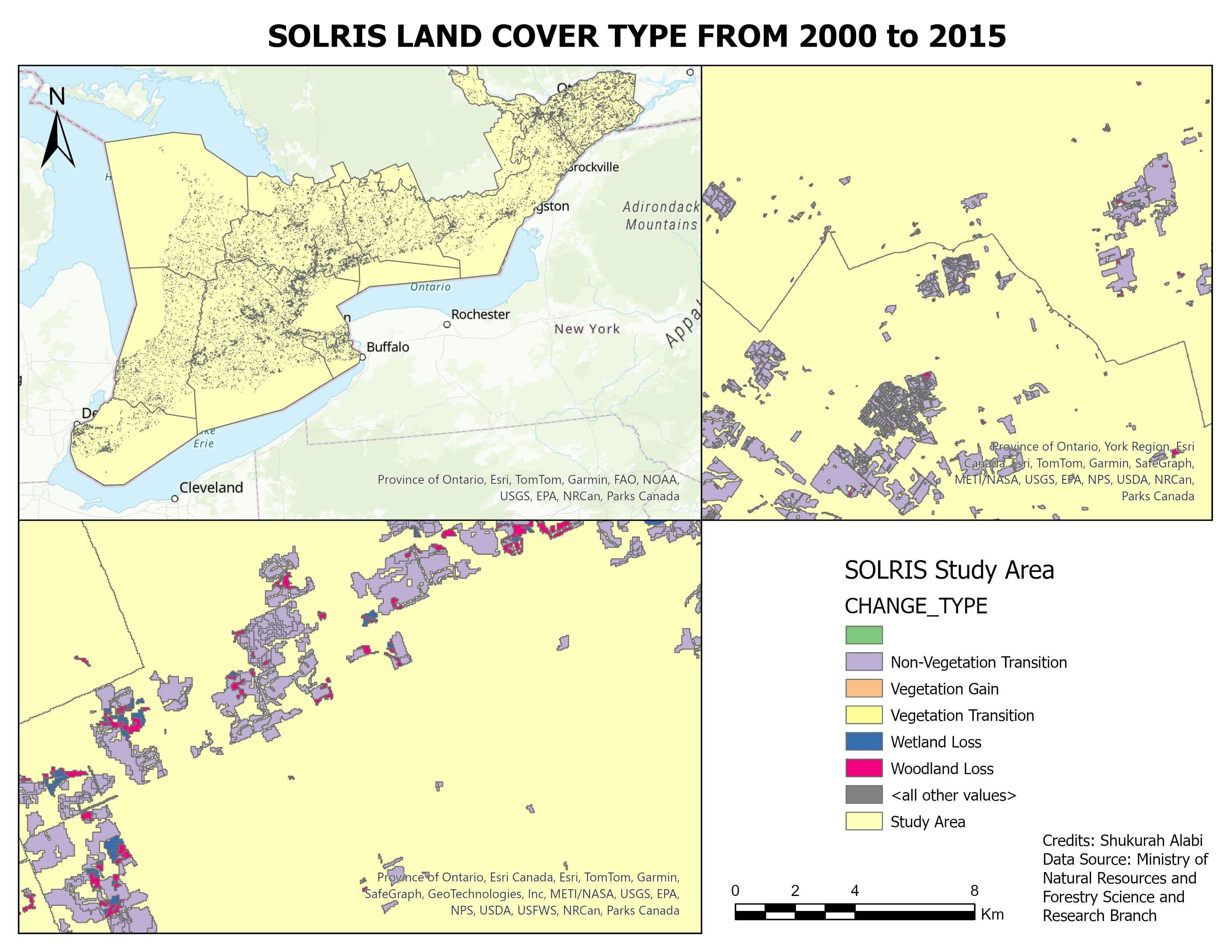
🗺️ Map Layout: I dive deeper into the details with a map layout showcasing the various change types observed in the study area. From non-vegetation transitions to wetland losses, every shift is a piece of the larger environmental puzzle. 🧩🗺️
Objectives Achieved:
1. I identified significant land cover transformations using SOLRIS classes.
2. I explored change causes, including anthropogenic, natural, and weather-related factors.
3. I visualized the intensity of changes over different time periods.
Future Analysis Possibilities:
🔍 Change Detection: Exploring advanced techniques for more accurate change detection, considering factors like image resolution and spectral analysis.
📈 Quantifying Impact: Assessing the environmental impact of identified changes, connecting land cover shifts to broader ecological consequences.
🌱 Predictive Modeling: Utilize machine learning algorithms to predict future land cover changes and their potential implications.
I am excited about the possibilities that lie ahead for deeper environmental insights! 🚀Join me to continue exploring and understanding our planet's dynamic ecosystems. 🌐✨
Learn more about the SOLRIS data information here: https://lnkd.in/gRc9J4C3
hashtag#LandCoverAnalysishashtag#SOLRISDatasethashtag#GIShashtag#DataVisualizationhashtag#ChangeDetection


.svg "Alec Soltes")