Sign up or log in to your Spatialnode account.

Takes less than a few seconds.

Death by Design

Sara Fatimah
Sara Fatimah•

May 05, 2022

Death by Design

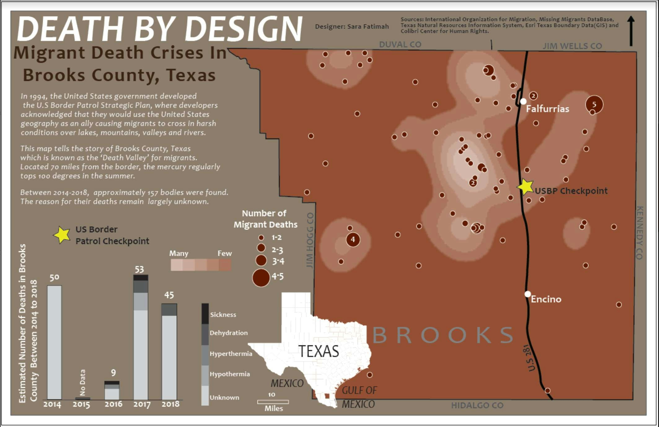
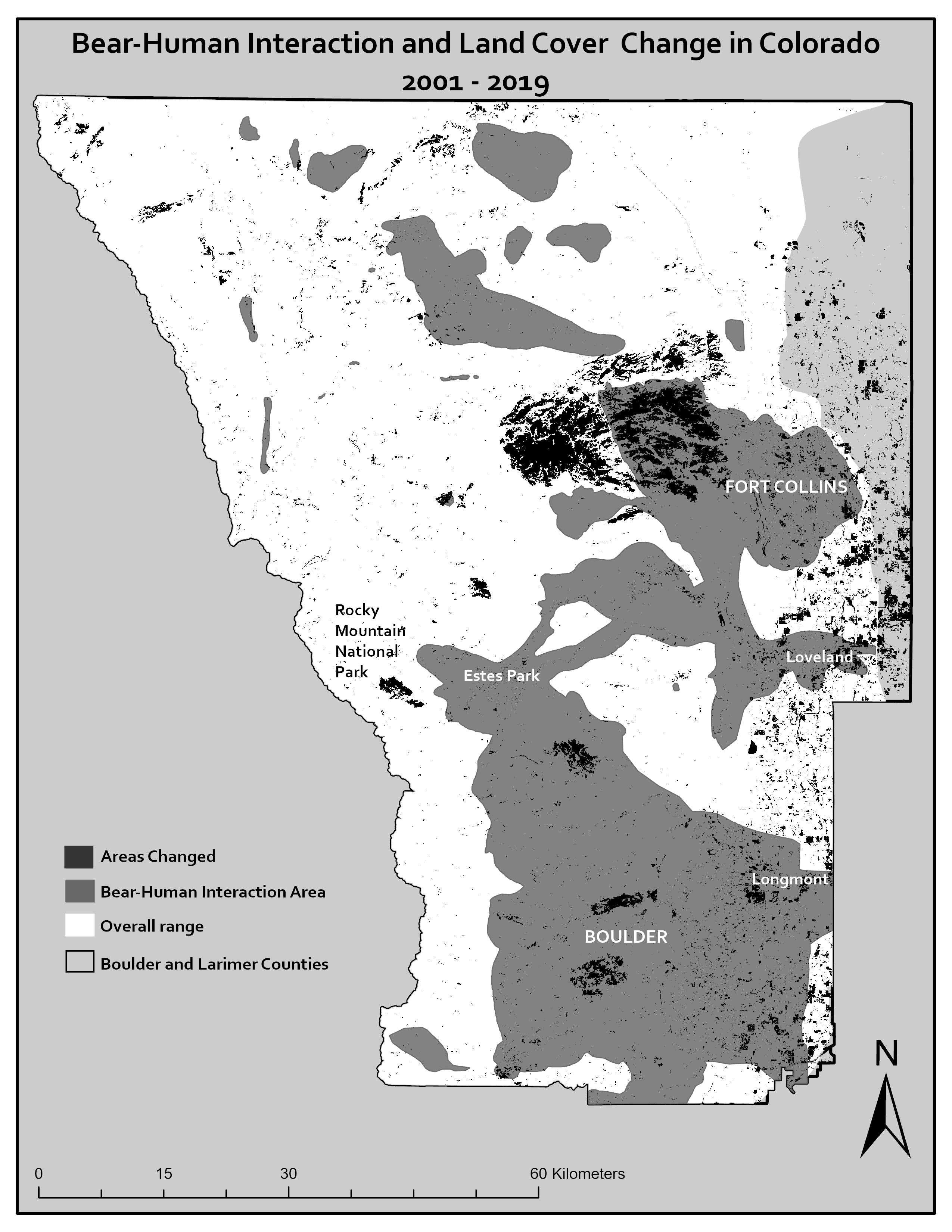
Map tells story of Migrant Death Count in Brooks County, TX. Made in 2019.

Software used: ArcMap, Adobe Illustrator


Tools used

Adobe IllustratorArcMap

Plug-ins used

ArcMapSpatial analyst

tags

ArcMapCartographyilustration

More by Sara Fatimah

2001 Landcover, Northern Colorado
24
Human Bear Interaction
46
Interactive Air Quality Map
115
Woody Areas & Postgraduates in DC
30
Following the Desert Locusts
87
Map for a project in Eastern Siberia
33
Landsat 8: Mapping Wildfires
17
Mapping Wildfires in Eastern Siberia
28
Prince of Wales Island.
13
2019 Landcover Northern Colorado
43
Landslide Hazard Assesment
32
Study Area & Black Bear Habitat
22

You might also like

Bacias Hidrográficas do Maranhão
Pedro Ferreira
Bacias Hidrográficas do Maranhão
Pedro Ferreira
1.3K
Life Quality Index for Reconquista Basin
Carolina Byl
Life Quality Index for Reconquista Basin
Carolina Byl
45
AGOL - BCS Data Viewer
Jeffrey Erwin
AGOL - BCS Data Viewer
Jeffrey Erwin
12
Map a Month: June
Cari Lynn Squibb
Map a Month: June
Cari Lynn Squibb
8
Mapa da Bacia Hidrográfica do Rio Doce
Henrique Cesar Bitencourt
Mapa da Bacia Hidrográfica do Rio Doce
Henrique Cesar Bitencourt
199
Zonas Climáticas de Minas Gerais
Raiane Mechetti Ferreira
Zonas Climáticas de Minas Gerais
Raiane Mechetti Ferreira
46
Land Capability Classification Map
Muhammad Nabiel
Land Capability Classification Map
Muhammad Nabiel
9
Havana Arterial City
Dayniel Hernández Mestre
Havana Arterial City
Dayniel Hernández Mestre
160
MAPA DAS REGIÕES DE ANGOLA
Fenando Paulo Neto Alberto
MAPA DAS REGIÕES DE ANGOLA
Fenando Paulo...
863
Environmental Zoning of Niterói
rafael menezes de souza
Environmental Zoning of Niterói
rafael menezes...
58
Pontos de Coleta de Solo - EPAGRI
Hildeberto Macêdo
Pontos de Coleta de Solo - EPAGRI
Hildeberto Macêdo
10
Seasonal Deviation using CHIRPS data
Adriana Calderon
Seasonal Deviation using CHIRPS data
Adriana Calderon
21

Join the community!

We're a place where geospatial professionals showcase their works and discover opportunities.

Sign Up for free