CASE STUDY
GIS Key to Rocketing Ikeja Power Availability
Ikeja Electric (IE), Nigeria's largest electric power distribution company, was founded in 2013. This followed the privatization of the power sector. The utility serves over 900,000 customers in a 400-square-mile area centered around Nigeria's largest city, Lagos.
Challenge
Until privatization, electricity service was seen mainly as a social service to its people and businesses. However, the lack of funding, irregular collection practices, obsolete equipment, and lack of good data often left customers in the dark. They received on average only 10 hours of power a day. As a result, customers resorted to connecting to local generators to supply power the remaining hours in the day. This created problems such as pollution, safety hazards, and additional costs. Customers wanted IE to supply all their power needs.
In addition, during the COVID-19 pandemic, more people had to work from home. As a result, lacking power became a more significant issue for the people.
To improve availability, IE had to significantly upgrade the infrastructure. It was badly in need of modernization. Lack of data created a blindness to the condition of the network. The process was to collect data in notebooks, then copy it into spreadsheets. IE had no paper maps, let alone digital ones. IE desperately needed to understand its customers' connection to the electric network. There was another serious problem. IE needed additional funding to accomplish its goal.
Solution
Before IE could embark on an aggressive improvement program, it had to create a solid understanding of its network and customers. IE needed location technology. In 2015 IE embarked on implementing a geographic information system (GIS) program. IE's new management's vision was to leverage technology to improve service availability dramatically.
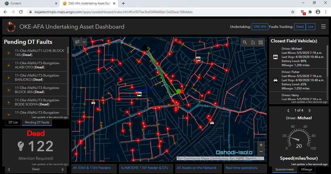
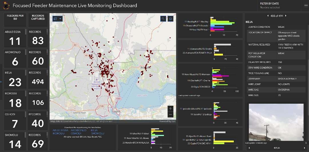
In addition to availability issues, random power outages were rampant. Field crews needed better data to be able to track down where damages occurred. They needed to know which equipment was damaged and to what extent. See how IE used GIS to dramatically improve its outage response using ArcGIS and real-time SCADA and smart meters data here.
IE still needed to address the lack of power availability. IE used GIS to create an innovative approach to improve availability and raise money. IE called this its Willing Buyer, Willing Seller initiative dubbed Bilateral Power Program. IE reached out to its customers to see which areas would pay more for greater availability. The pitch was that for the extra cost, load shedding, or the deliberate cutting of power for those participating in the program, would be severely curtailed. In addition, customers would get additional equipment that could wheel more power to their homes. Part of the issue of availability was that equipment was too often overloaded and regularly failed.
Ikeja Electric used the GIS to help identify weaknesses in the network. It also used the GIS to design improvements and direct field crews to install the new equipment.
Eleven community development regions signed on to the program. However, IE needed better data. One of the outstanding data issues was the relationship of the customer to the supplying transformer. IE used teams of 20 field crews who used Esri's ArcGIS Survey123 to collect customer information, including pictures of properties, meters, and equipment. IE's GIS team members used this data to evaluate loading information and the condition of poles and switches. They were able to determine where to install additional transformers, replace inadequate conductors, and perform additional maintenance on the equipment.
Workers reported the system was fast and straightforward.
Results
The results are nothing short of dramatic. Availability of service more than doubled with supply reaching more than 20 hours a day. While the service cost has increased for those participating in the program, most customers are highly pleased.
IE innovation resulted in a program that, in effect, pays for itself and provides access to affordable and reliable power supply in line with the Sustainable Development Goal (SDG #7). ArcGIS analytics and data collection capability combined to provide a solid understanding of its customer and network and enabled the success of the Bilateral Power Program initiative.

.jpg&w=3840&q=100)