Sign up or log in to your Spatialnode account.

Takes less than a few seconds.

IdahoDarkRoads

Michael Nau
Michael Nau•

November 08, 2022

IdahoDarkRoads

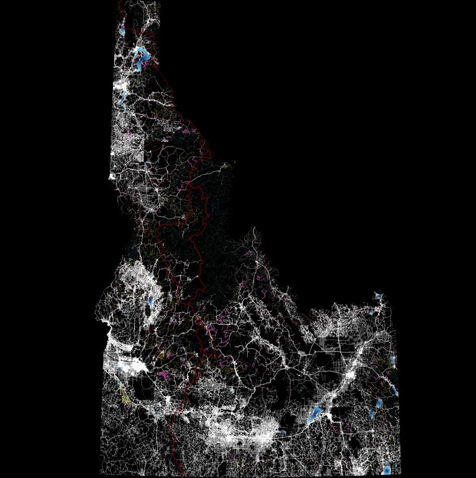
This is a fun cartography map of Idaho using roads and waterways with a bonus layer of Centennial trail highlighted


Tools used

ArcPro

Plug-ins used

Defense Mapping

tags

ArtCartographyDarkIdaho

More by Michael Nau

Great State of Idaho
38
Taste of Shed hunting
46
Wedding Seating Chart
41
Warm Lake Idaho 2024
38
Historical shift 1943 to 2020
67
Story Board, Idaho Military Division
44
USGS Topo 1909 Idaho Modern Hillshade
35
PRISM Precipitation Data in Hex
59
Surface Drainage
Surface Drainage
89
Heart of the Salmon River
68

You might also like

Declividade Corrego Marrecas
luiz felipe maçon
Declividade Corrego Marrecas
luiz felipe maçon
10
MAP OF FARM OVERLAID ON CLASSIFIED IMAGE
Edidiong Ekrikpo
MAP OF FARM OVERLAID ON CLASSIFIED IMAGE
Edidiong Ekrikpo
9
Mapa de vegetação do estado de SP
Rodrigo Chemite Barbosa
Mapa de vegetação do estado de SP
Rodrigo Chemite Barbosa
12
Historical Fiction Reference Map
Sherri Michl
Historical Fiction Reference Map
Sherri Michl
19
Mapa de Localização de Rio de Janeiro-RJ
Johnson Sarmento de O. Nascimento
Mapa de Localização de Rio de Janeiro-RJ
Johnson Sarmento...
35
Banneker Park Dashboard
Matthew Tomitz
Banneker Park Dashboard
Matthew Tomitz
13
Uso e Ocupação do Solo - Contagem/MG
Brenner Rodrigues
Uso e Ocupação do Solo - Contagem/MG
Brenner Rodrigues
9
Temperatura da Macrometrópole da RMSP
Sidney dos Santos
Temperatura da Macrometrópole da RMSP
Sidney dos Santos
118
Alcoser watershed
Aahed Alhamamy
Alcoser watershed
Aahed Alhamamy
188
Linhas utopicas de VLT de São Luís - MA
Thiago Andrade
Linhas utopicas de VLT de São Luís - MA
Thiago Andrade
220
Wildfire Burn Map in 2021 California
Akshar Patel
Wildfire Burn Map in 2021 California
Akshar Patel
54
Flood Hazard Mapping in QGIS
Peter Kimani
Flood Hazard Mapping in QGIS
Peter Kimani
184

Join the community!

We're a place where geospatial professionals showcase their works and discover opportunities.

Sign Up for free