Sign up or log in to your Spatialnode account.

Takes less than a few seconds.

Map of Ekwusigo LGA, Anambra State

Chukwulobe Martins Ugonna
Chukwulobe Martins Ugonna•

February 02, 2023

Map of Ekwusigo LGA, Anambra State

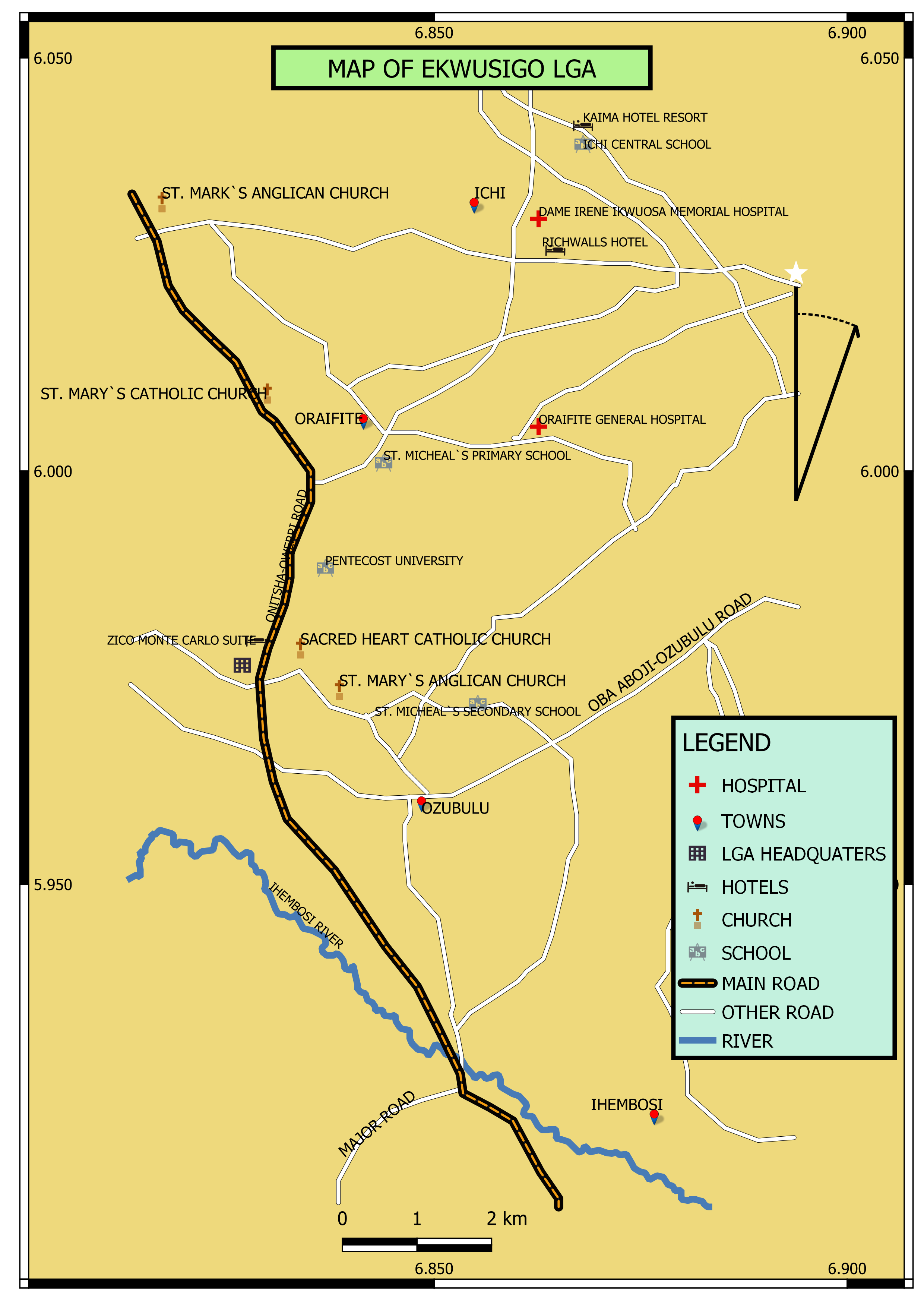
I used Google map as a base map and QGIS for the rendering


Tools used

QGIS

Plug-ins used

Nill

tags

Nigeria

More by Chukwulobe Martins Ugonna

Hypothetical security map of Nigeria
20
Map of Enugu state showing road network
483
Map of Udi LGA in Enugu State, Nigeria
208
Map of Kogi State
Map of Kogi State
669
Elevation map of Uzo Uwani Enugu State
43
Map of Kogi state highlighting Lokoja
501
Map of Anambra classed by Population
397
Contour map of Enugu State, Nigeria
416

You might also like

Registered Filipino Emigrants per Capita
Francis Emmanuel Calingo
Registered Filipino Emigrants per Capita
Francis Emmanuel CalingoPro
10
Bus Accessibility in Ventura County
Whitney
Bus Accessibility in Ventura County
Whitney
8
DSM of SRUC Oatridge campus
Kelvin Boateng
DSM of SRUC Oatridge campus
Kelvin Boateng
6
Hydrographic Survey Map
Elizabeth Ugwu
Hydrographic Survey Map
Elizabeth Ugwu
20
Mapa Comparativo sobre o método (DOS)
Breno Nunes
Mapa Comparativo sobre o método (DOS)
Breno Nunes
15
IMPACTS OF URBANIZATION ON WETLANDS
Choolwe Hamama
IMPACTS OF URBANIZATION ON WETLANDS
Choolwe Hamama
116
Dam Quantity Assessment
Marvin Ayeh
Dam Quantity Assessment
Marvin Ayeh
24
Arctic Sea Ice Decline
Sammer
Arctic Sea Ice Decline
Sammer
13
Distribution of Caridina species
Philip Russo
Distribution of Caridina species
Philip Russo
466
Uso do solo temporal 1990 a 2020
Márcio Marques de Alencar Arraes
Uso do solo temporal 1990 a 2020
Márcio Marques...
45
Analizing camera trap results
Angela Mejia
Analizing camera trap results
Angela Mejia
14
Land Use Mix Of Woodstock Municipality.
Sunder Gurung
Land Use Mix Of Woodstock Municipality.
Sunder Gurung
75

Join the community!

We're a place where geospatial professionals showcase their works and discover opportunities.

Sign Up for free