Sign up or log in to your Spatialnode account.

Takes less than a few seconds.

Stormy timelapse 🌩️

Alexa Cristina
Alexa Cristina•

February 11, 2022

Stormy timelapse 🌩️

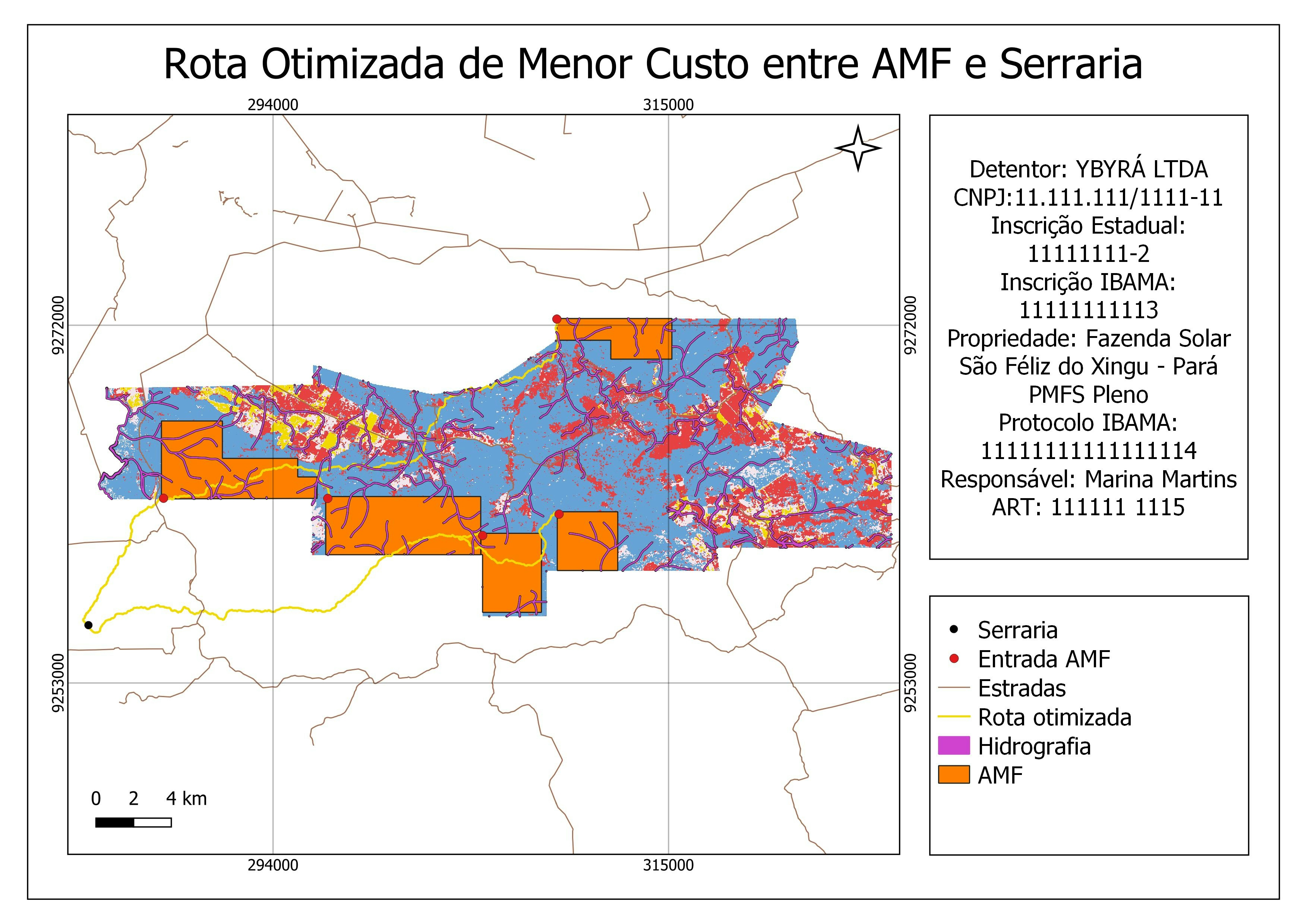
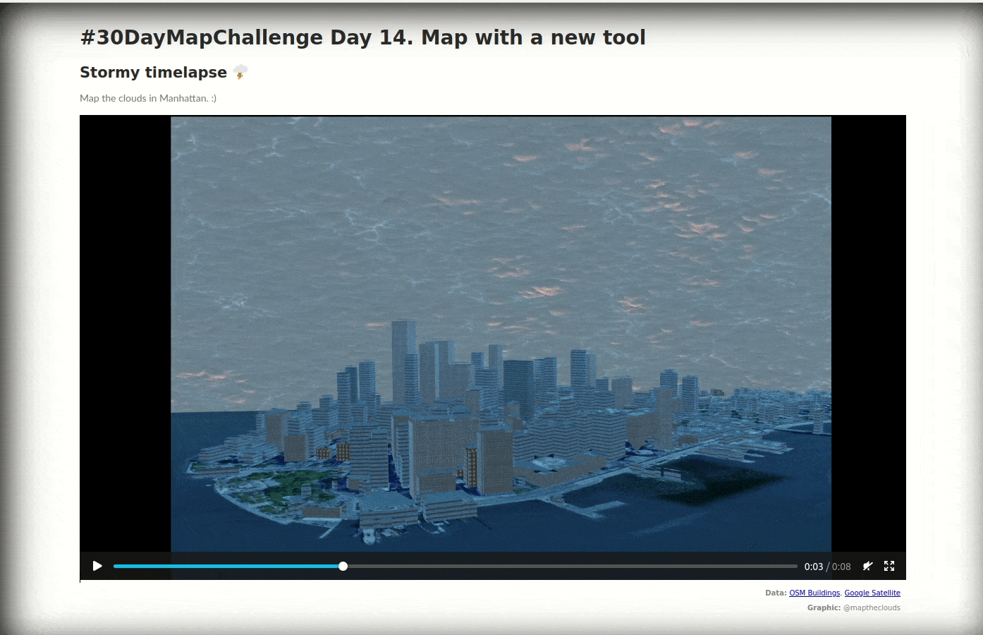
Map the clouds in Manhattan. :)

Data: OSM Buildings, Google Satellite

Demo

Tools used

Blender

Plug-ins used

Blender

tags

Blender

More by Alexa Cristina

The Hexagonal Nose ⬡⬡⬡
4
Cluj County
Cluj County
16
Corgi Routes 🙂
Corgi Routes 🙂
20
Populated Places on Earth 🌍
84
Lights Heatmap 🌃
Lights Heatmap 🌃
59
Earth gone wild! Green edition. 💚
17
The many faces of elections - Cartograms
52
Population per administrative units Map
22
Earth in Blender 🌎
Earth in Blender 🌎
100
People Constellations ✨
43
Dancing City
Dancing City
28
Multiple and Flexible Pathways
154

You might also like

NM Gross Farm Income, Crops, & Livestock
Keran Nkongolo
NM Gross Farm Income, Crops, & Livestock
Keran NkongoloPro
5
CSUF Campus Tree Map (Fall 2016)
Amanda
CSUF Campus Tree Map (Fall 2016)
Amanda
11
Mapa de Localização UAPS, Fortaleza - CE
SUSANE LAIS DA SILVA CHAVES
Mapa de Localização UAPS, Fortaleza - CE
SUSANE LAIS...
89
Spectral profile of point(western Egypt)
Sarah Abd Elsamea
Spectral profile of point(western Egypt)
Sarah Abd Elsamea
75
Mapa Hipsométrico - Ouro Preto/MG
João Alison Dionísio Mendonça
Mapa Hipsométrico - Ouro Preto/MG
João Alison...
128
Population Density Analysis
Farhan Towsif
Population Density Analysis
Farhan Towsif
3
mapa temático
Edmundo C S Junior
mapa temático
Edmundo C...
7
Teresina - 1ª cidade planejada do Brasil
Felipe Dantas
Teresina - 1ª cidade planejada do Brasil
Felipe Dantas
40
Bike Safety in a L.A. County City: LHH
Amanda
Bike Safety in a L.A. County City: LHH
Amanda
7
Patchouli Plant Land Suitability Map
Adhira Riza Muqtadir
Patchouli Plant Land Suitability Map
Adhira Riza Muqtadir
7
Land Use Plan - Santa Cruz, Bolivia
Marcelo Aguilera
Land Use Plan - Santa Cruz, Bolivia
Marcelo Aguilera
511
Mapping Wetland and Swampy Topography
Desmond Twum
Mapping Wetland and Swampy Topography
Desmond Twum
19

Join the community!

We're a place where geospatial professionals showcase their works and discover opportunities.

Sign Up for free