Method
The work involved using remote sensing techniques to assess water quality through two key indices: NDVI (Normalized Difference Vegetation Index) and SABI (Satellite-Derived Aquatic Biogeochemical Indicators). NDVI is commonly used to evaluate vegetation vigor, but it can also provide limited insights into water quality. On the other hand, SABI focuses on obtaining biogeochemical indicators of water quality in aquatic systems using satellite imagery, offering more accurate assessments.
The NDVI is calculated using near-infrared (NIR) and red light spectral bands recorded by remote sensing devices. It is given by the formula: NDVI = (NIR - Red) / (NIR + Red).
The SABI method aims to derive biogeochemical indicators of water quality, such as turbidity, suspended particulate matter (SPM), colored dissolved organic matter (CDOM), and chlorophyll-a concentration. It is calculated as: SABI = (Band2 - Band1) / (Band2 + Band1).
Result
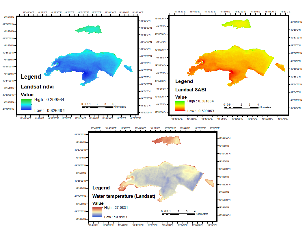
The study evaluated the water quality of a specific water body (subset) using Landsat remote sensing data and provided image evaluations for both NDVI and SABI.
Landsat NDVI: The NDVI image showed variations in water contamination, with the highest pixel value of 0.29 indicating high impurity in the northern areas, and the lowest value of -0.82 in less contaminated regions. However, the delineation of water contamination seemed inadequate.
Landsat SABI: The Landsat SABI index offered clearer delineation of contamination levels, with green indicating increased contamination, yellow for mild contamination, and red for a pure section of the water body. The highest contamination (0.38 pixels) was observed in the upper fragment, while the lowest contamination values were around -0.5 and -0.36 in the south and southwest areas, respectively.
Water Temperature: The evaluation of water temperature using Landsat data showed higher temperatures around the outskirts of the water body, particularly in the north (24.25 pixels) and west (24.20 pixels). The warmest point (27 pixels) was located in the east, while cooler temperatures (around 19.5 pixels) were found away from the edges.