Sign up or log in to your Spatialnode account.

Takes less than a few seconds.

Osun State elections 2022

Emeka Ude
Emeka Ude•

November 22, 2022

Osun State elections 2022

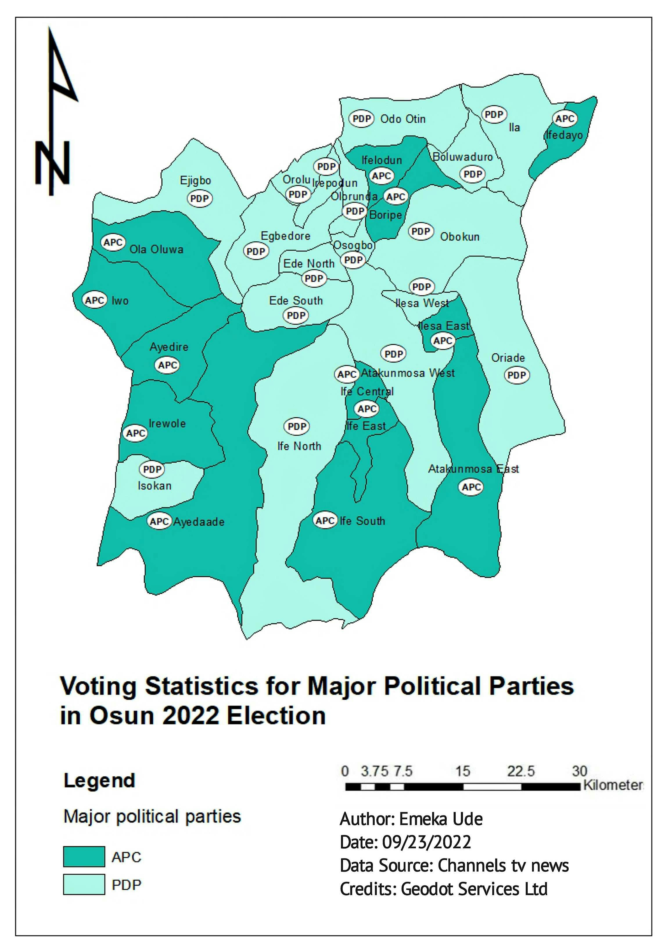
Performance of major political parties per LGA in the Osun State elections 2022


Tools used

ArcMap

Plug-ins used

ArcMap

tags

elections

More by Emeka Ude

Delineations of Asa River Watershed
95
Topographical Map of Lagos Mainland
74
Geochemical Map in Southwest, Nigeria
21
Traverses of Geophysical Survey, Unilag
10
Study Area in Southwest Nigeria
21
Topographic Map of Obukpa
127
Study Area Map of Nsukka Metropolis
94
Liberty Ibadan Street Map
34
EzeAni Groundwater Quality
46
Elevation Map of Abakaliki Nigeria
39
Hourly Ozone Distribution in California
66
Temperature Along Nigerian Coastal Line
34

You might also like

Geological map of Pakistan, My 1st prjct
Arman Alam
Geological map of Pakistan, My 1st prjct
Arman Alam
14
Série histórica Rio das Velhas - MG
Luiz Prado
Série histórica Rio das Velhas - MG
Luiz Prado
414
Jbel Moussa Landscape
Hamza Bouarakia
Jbel Moussa Landscape
Hamza Bouarakia
194
Mapa de Localização de São Lourenço (MG)
Gabriel Martins Corrêa
Mapa de Localização de São Lourenço (MG)
Gabriel Martins Corrêa
272
Reproject, Resample and Clip Raster
Paola Prieto Botero
Reproject, Resample and Clip Raster
Paola Prieto Botero
11
3D Land Change Animation
Zach Torres
3D Land Change Animation
Zach Torres
95
Mapa dos municípios comunidades tr da PB
Jonatha Iuri
Mapa dos municípios comunidades tr da PB
Jonatha Iuri
47
Shaded relief map of Australia
Balogun Temitope
Shaded relief map of Australia
Balogun Temitope
703
Cobertura do Solo - Região de Brasília
Murilo Silva
Cobertura do Solo - Região de Brasília
Murilo Silva
11
Mapa Agrícola para Penhor de Grãos
Simone Malhado da Silva
Mapa Agrícola para Penhor de Grãos
Simone Malhado...
4
HIDROGRAFIA - REBIO DO TINGUÁ
Williane de Vasconcelos Meneses
HIDROGRAFIA - REBIO DO TINGUÁ
Williane de...
9
Composição RGB - morfometria
anderson rodrigues ribeiro
Composição RGB - morfometria
anderson rodrigues ribeiro
4

Join the community!

We're a place where geospatial professionals showcase their works and discover opportunities.

Sign Up for free