Sign up or log in to your Spatialnode account.

Takes less than a few seconds.

Elevation Map of Abakaliki Nigeria

Emeka Ude
Emeka Ude•

July 10, 2023

Elevation Map of Abakaliki Nigeria

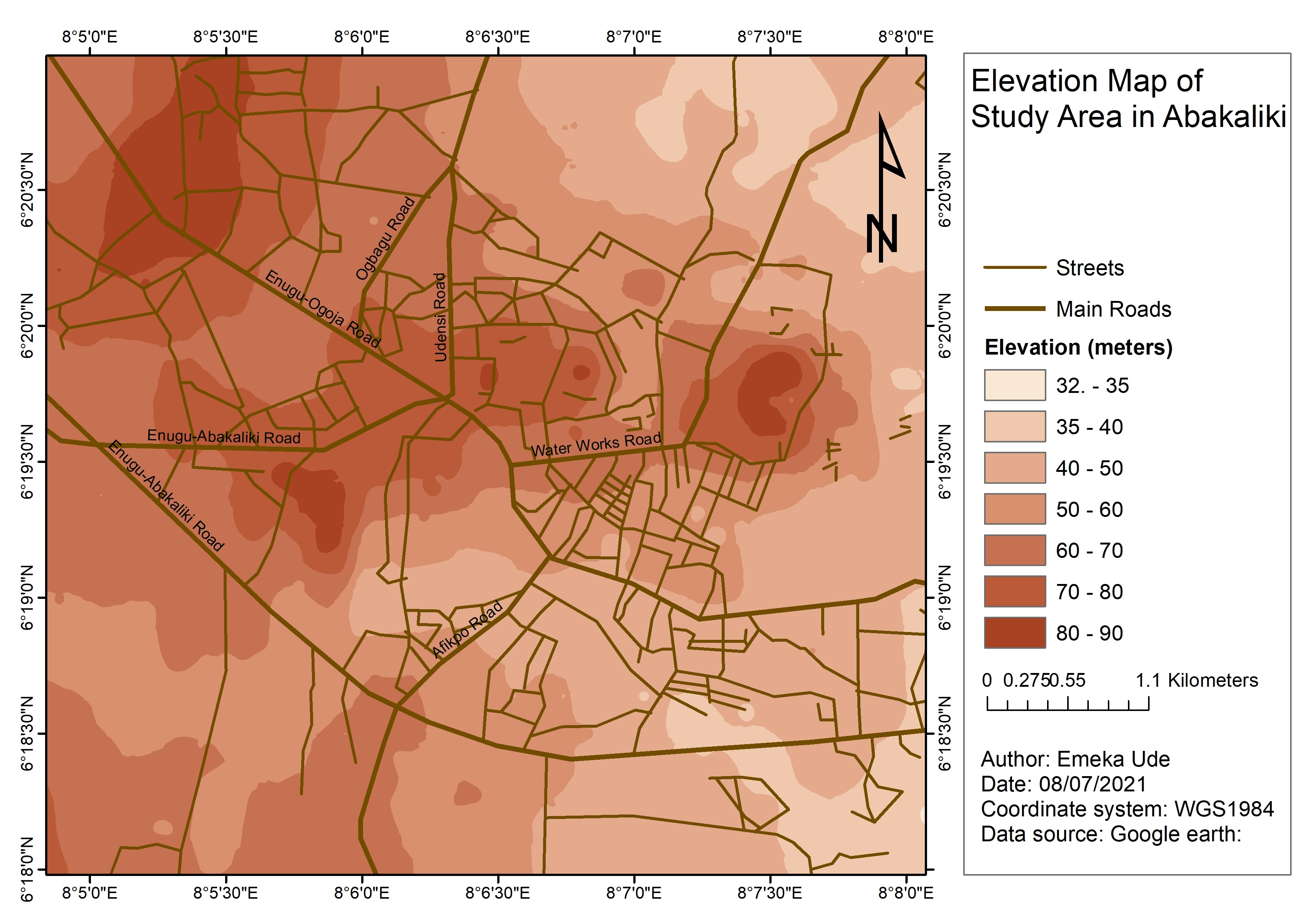
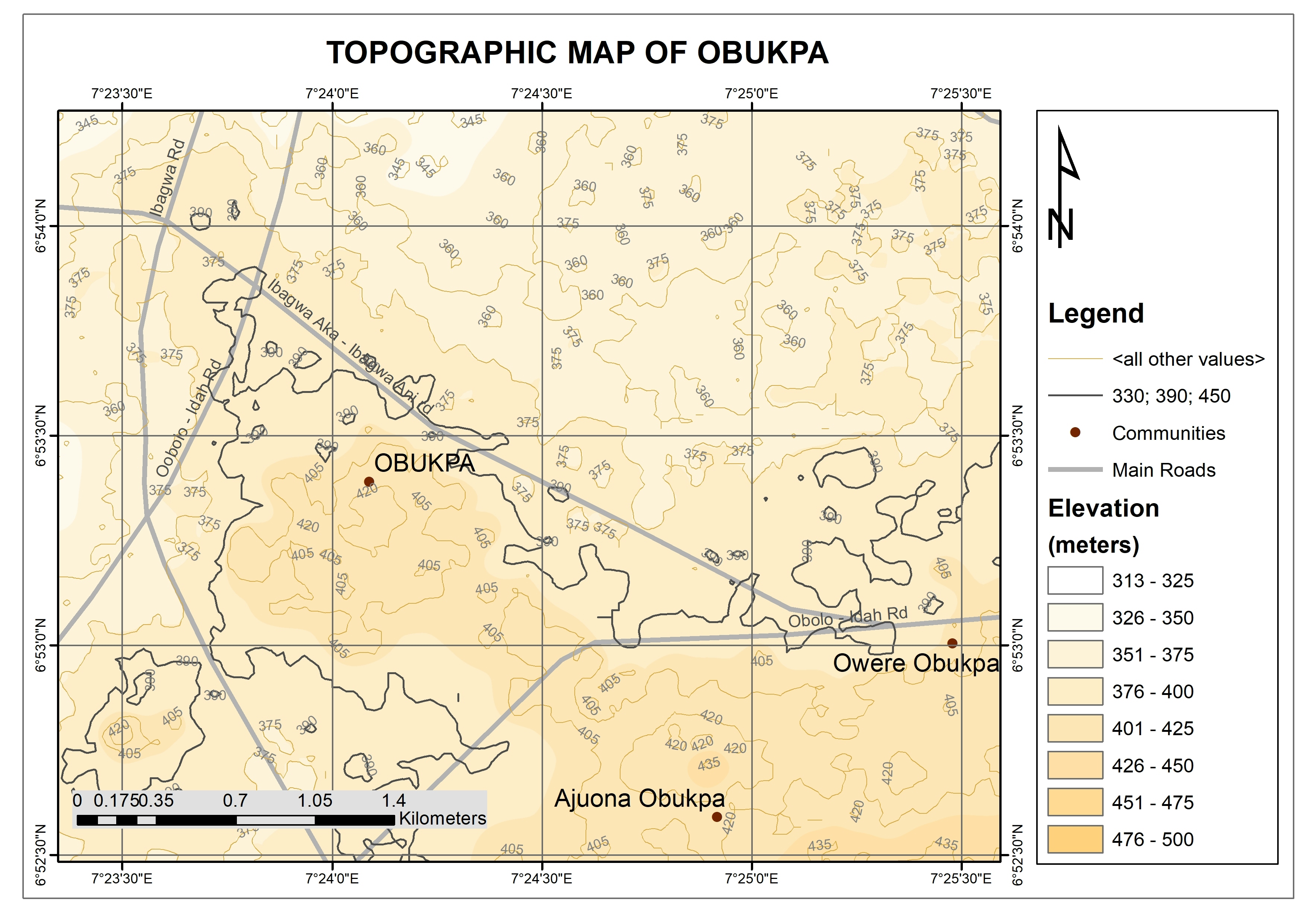
This depicts the Elevation map of the Abakaliki town of Ebony I state Nigeria. This study was in 2021 and is Showing distribution of high and low lands


Tools used

ArcGISGoogle Earth ProMicrosoft Excel

Plug-ins used

ArcMap

tags

DEMElevation

More by Emeka Ude

Study Area in Southwest Nigeria
25
Temperature Along Nigerian Coastal Line
34
Traverses of Geophysical Survey, Unilag
12
Topographical Map of Lagos Mainland
92
Delineations of Asa River Watershed
100
Hourly Ozone Distribution in California
66
Topographic Map of Obukpa
139
Study Area Map of Nsukka Metropolis
115
Geochemical Map in Southwest, Nigeria
21
EzeAni Groundwater Quality
47
Liberty Ibadan Street Map
36
Osun State elections 2022
95

You might also like

Test
Kaitlyn Perham
Test
Kaitlyn Perham
11
Carbonate Formations of Attica (greek)
Efstathios Lymperis
Carbonate Formations of Attica (greek)
Efstathios Lymperis
186
World Mine Production Manganese 2021
Miriela Ulloa Santana
World Mine Production Manganese 2021
Miriela Ulloa Santana
237
Pantabangan-Carranglan Watershed
Juan Carlos Gabriel Zacarias
Pantabangan-Carranglan Watershed
Juan Carlos...
36
Arsenic in Durango, Mexico
Keran Nkongolo
Arsenic in Durango, Mexico
Keran NkongoloPro
26
Wyoming Catttle
Keran Nkongolo
Wyoming Catttle
Keran NkongoloPro
13
NM Gross Farm Income, Crops, & Livestock
Keran Nkongolo
NM Gross Farm Income, Crops, & Livestock
Keran NkongoloPro
5
HIPSOMETRIA MICROBACIA DO RIBEIRÃO CAIUÁ
Itamar Sateles de Sá
HIPSOMETRIA MICROBACIA DO RIBEIRÃO CAIUÁ
Itamar Sateles...
58
Micro Habitat
Marvin Ayeh
Micro Habitat
Marvin Ayeh
14
Flood Hazard Mapping in QGIS
Peter Kimani
Flood Hazard Mapping in QGIS
Peter Kimani
138
Mapa hipsométrico
Lucas Moreira
Mapa hipsométrico
Lucas Moreira
16
Maryland Soybean and Corn
Keran Nkongolo
Maryland Soybean and Corn
Keran NkongoloPro
32

Join the community!

We're a place where geospatial professionals showcase their works and discover opportunities.

Sign Up for free