Sign up or log in to your Spatialnode account.

Takes less than a few seconds.

Suitability analysis

Kolawole Arowoogun
Kolawole Arowoogun•

November 22, 2021

Suitability analysis

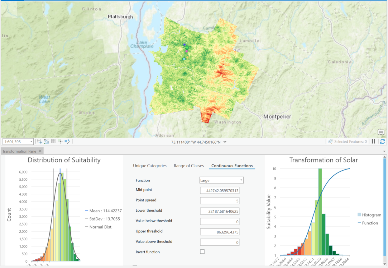
Suitability analysis model for determining the locations of a proposed low carbon footprint headquarter in Vermont.


Tools used

ArcGIS Pro

Plug-ins used

ArcGIS Pro

tags

ArcGIS Pro

More by Kolawole Arowoogun

Hotspot
Hotspot
610
Mount Helen Eruption Map
254
Outlier analysis
Outlier analysis
618
Supervised classification image of Hall County, Georgia
254
Algae bloom
Algae bloom
628
Mapping 2021 Dixie wildfire.
292
Map of Tract and census population data
35
Visualizing 2016 US Election
248
NDVI Map of Fulton County
73
Outlier analysis
Outlier analysis
601
Supervised Classification Map of Hall County, Georgia
240

You might also like

Mapa Precipitação
Marco Zero Geologia
Mapa Precipitação
Marco Zero Geologia
89
Sensitive Species in San Diego County
Jacob Helfman
Sensitive Species in San Diego County
Jacob Helfman
88
Saguling Microworld Diorama
Mohammad Farhan Fadillah
Saguling Microworld Diorama
Mohammad Farhan Fadillah
183
TTC Subway
Marcelo Aguilera
TTC Subway
Marcelo Aguilera
241
NDVI
Arthur Braz Farias
NDVI
Arthur Braz Farias
35
Biodiversity assessment - Shannon index
Marta Rueda Pasadas
Biodiversity assessment - Shannon index
Marta Rueda Pasadas
30
AGOL - GIS Request Management Solution
Jeffrey Erwin
AGOL - GIS Request Management Solution
Jeffrey Erwin
10
Biomas do Brasil
Mauricio Matheus
Biomas do Brasil
Mauricio Matheus
13
LANDUSE/LANDCOVER MAP OF KETA LAGOON
Emmanuel Opoku
LANDUSE/LANDCOVER MAP OF KETA LAGOON
Emmanuel Opoku
4
Mapa de caminhamento ADA e AID
Lucas Moreira
Mapa de caminhamento ADA e AID
Lucas Moreira
14
Mapa de Declividade - Natal/RN
João Alison Dionísio Mendonça
Mapa de Declividade - Natal/RN
João Alison...
35
Uso da terra no PARNA Catimbau
Matheus Maciel
Uso da terra no PARNA Catimbau
Matheus Maciel
13

Join the community!

We're a place where geospatial professionals showcase their works and discover opportunities.

Sign Up for free