Sign up or log in to your Spatialnode account.

Takes less than a few seconds.

TARC Stops by Headway

Sean Willis
Sean Willis•

October 31, 2023

TARC Stops by Headway

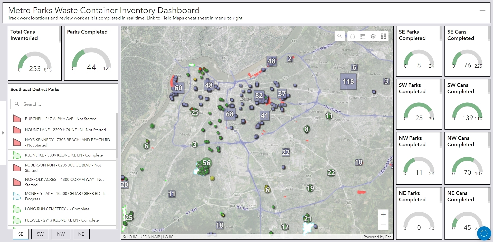
Created a public transit data model using GTFS data, then extruded stops based off the number of runs an hour.


Plug-ins used

N/A

tags

3DlouisvillePTDMPublic TransitPublic Transit Data Model

More by Sean Willis

Waste Container Inventory
22
Canopy Cover by Zip Code
126
Louisville Light Rail Proposal
88
TreesLouisville JCPS Plantings
45
Canopy Cover and Heat Severity
76
Intersection Collisions in Louisville
20
Priority Planting in Louisville, KY
121
Jefferson County Tax Income
60
Old Louisville Property Tax Income
17
Louisville, KY Housing Density
24
JCPS District 4 Tree Plantings
43
Tree Canopy in Redlined Districts
125

You might also like

Mapa Litológica
RODRIGO DE ARAUJO BELOTE
Mapa Litológica
RODRIGO DE...
1
Shropshire National Character Areas
Millie Brand
Shropshire National Character Areas
Millie Brand
12
Illinois Obesity Prevalence Map
Tyler Holmes
Illinois Obesity Prevalence Map
Tyler Holmes
5
Área plantada e terras indígenas
Everaldo Rodrigues Mota Junior
Área plantada e terras indígenas
Everaldo Rodrigues...
126
Mapa Rodoviário São Paulo CIDE
Matheus Amaral Prates
Mapa Rodoviário São Paulo CIDE
Matheus Amaral Prates
11
changs In Local Climate Extremes
Gabriel Henrique Braga Matos
changs In Local Climate Extremes
Gabriel Henrique...
6
Fazenda Três Lagoas
Matheus Medici
Fazenda Três Lagoas
Matheus Medici
5
Mapeamento de uso do solo e Apps
Felipe Ferreira Monteiro
Mapeamento de uso do solo e Apps
Felipe Ferreira Monteiro
51
Mapa de Declividade P. N. do Caparaó
Alexandre Basílio Oliveira
Mapa de Declividade P. N. do Caparaó
Alexandre Basílio Oliveira
43
Rate of Infected Whatcom County
Drew S
Rate of Infected Whatcom County
Drew S
12
Child Marriage Cases
Atieno Owino
Child Marriage Cases
Atieno Owino
39
Flood Hazard Map of a Part of Lokoja
Elizabeth Ugwu
Flood Hazard Map of a Part of Lokoja
Elizabeth Ugwu
63

Join the community!

We're a place where geospatial professionals showcase their works and discover opportunities.

Sign Up for free