Sign up or log in to your Spatialnode account.

Takes less than a few seconds.

JCPS District 4 Tree Plantings

Sean Willis
Sean Willis•

August 09, 2022

JCPS District 4 Tree Plantings

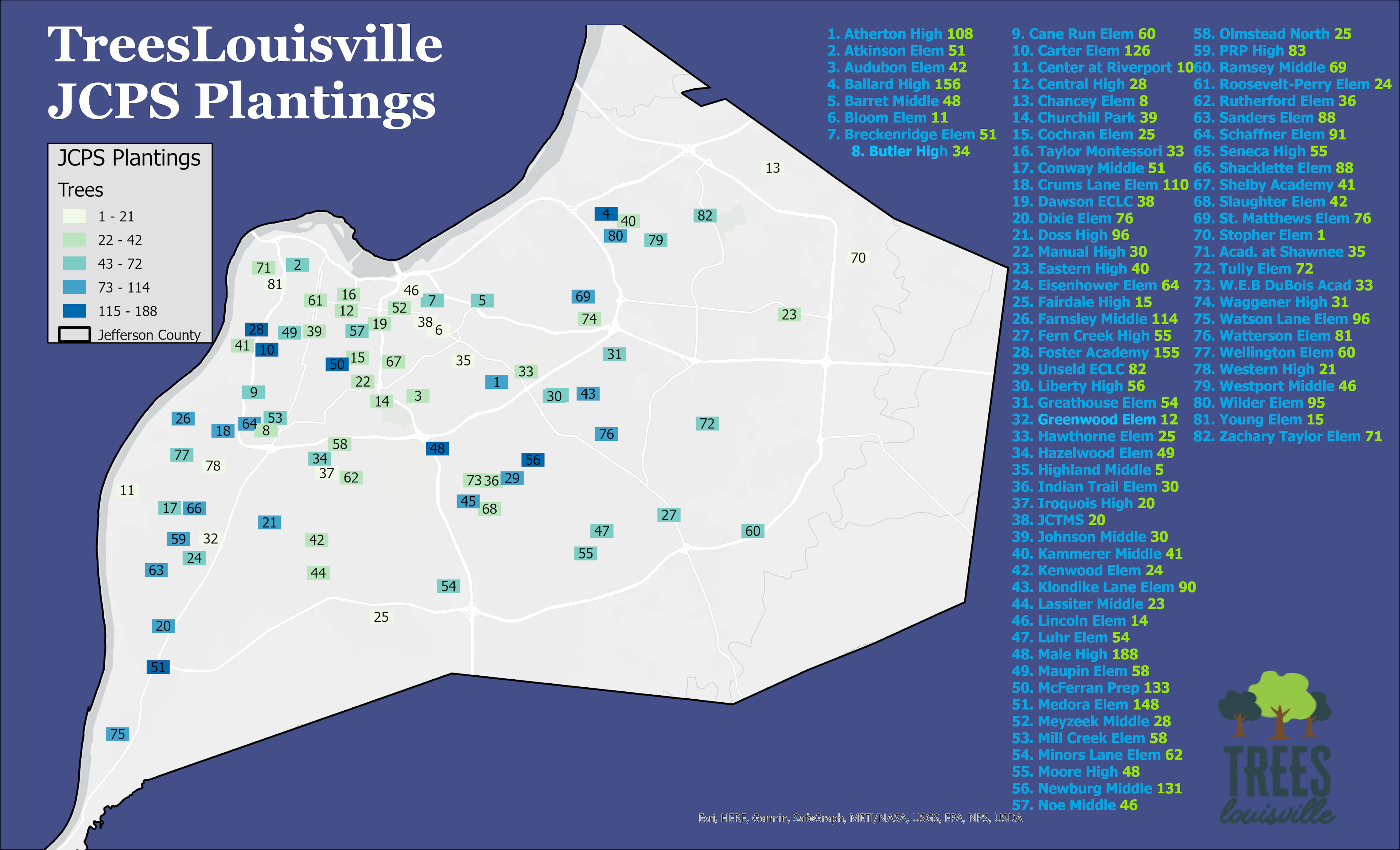
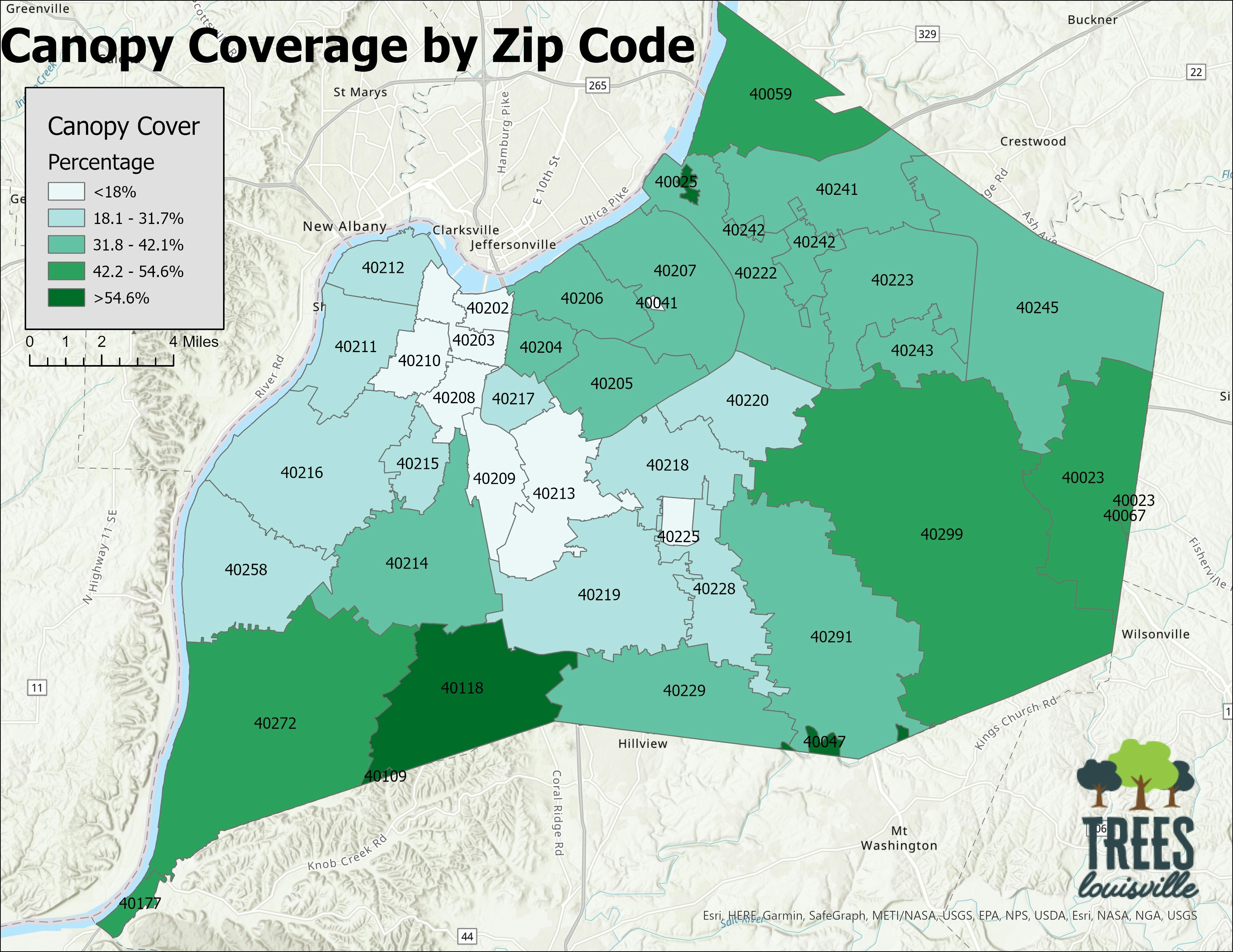
Made using tree data from Trees Louisville database/collector. It is part of a series of maps for each school district but I'm utilizing this as an example, since they all follow the same format.


Tools used

ArcGIS Pro

tags

canopyJCPSlouisvilletrees

More by Sean Willis

TARC Stops by Headway
17
Intersection Collisions in Louisville
22
Waste Container Inventory
23
Tree Canopy in Redlined Districts
134
Old Louisville Property Tax Income
23
Priority Planting in Louisville, KY
124
Jefferson County Tax Income
63
TreesLouisville JCPS Plantings
46
Louisville, KY Housing Density
28
Canopy Cover and Heat Severity
89
Canopy Cover by Zip Code
142
Louisville Light Rail Proposal
90

You might also like

Precipitação ES (Jan.23)
Glaucia de Oliveira Claudio
Precipitação ES (Jan.23)
Glaucia de...
41
Automated Rural Land Valuation
Kaio Serrano Galvão
Automated Rural Land Valuation
Kaio Serrano Galvão
30
IGR at the state level in Nigeria (2020)
Bamidele Daniel Ohinoyi
IGR at the state level in Nigeria (2020)
Bamidele Daniel Ohinoyi
59
Ramais em comunidades
ANDRE NOBREGA DE ARRUDA
Ramais em comunidades
ANDRE NOBREGA...
5
London region duration for 2019
Ologun Emmanuel Ayowole
London region duration for 2019
Ologun Emmanuel Ayowole
30
Evolução da linha do Ramal de Agudos
WILLIAN S. SANTOS 🇧🇷
Evolução da linha do Ramal de Agudos
WILLIAN S....
11
Map a Month: July
Cari Lynn Squibb
Map a Month: July
Cari Lynn Squibb
16
A story map about Frenchy, my dog
All That Geo
A story map about Frenchy, my dog
All That Geo
179
Densidade Populacional Proví. do Zaíre
Raduel Fernando da Fonseca
Densidade Populacional Proví. do Zaíre
Raduel Fernando...
86
Elevation map of the Ecuador
Marco Gonzalez
Elevation map of the Ecuador
Marco Gonzalez
140
LST Map of Ekiti State
Adewale Olayemi
LST Map of Ekiti State
Adewale Olayemi
80
Black Brook CHM
Michael Burnett
Black Brook CHM
Michael Burnett
18

Join the community!

We're a place where geospatial professionals showcase their works and discover opportunities.

Sign Up for free