Sign up or log in to your Spatialnode account.

Takes less than a few seconds.

TreesLouisville JCPS Plantings

Sean Willis
Sean Willis•

December 07, 2022

TreesLouisville JCPS Plantings

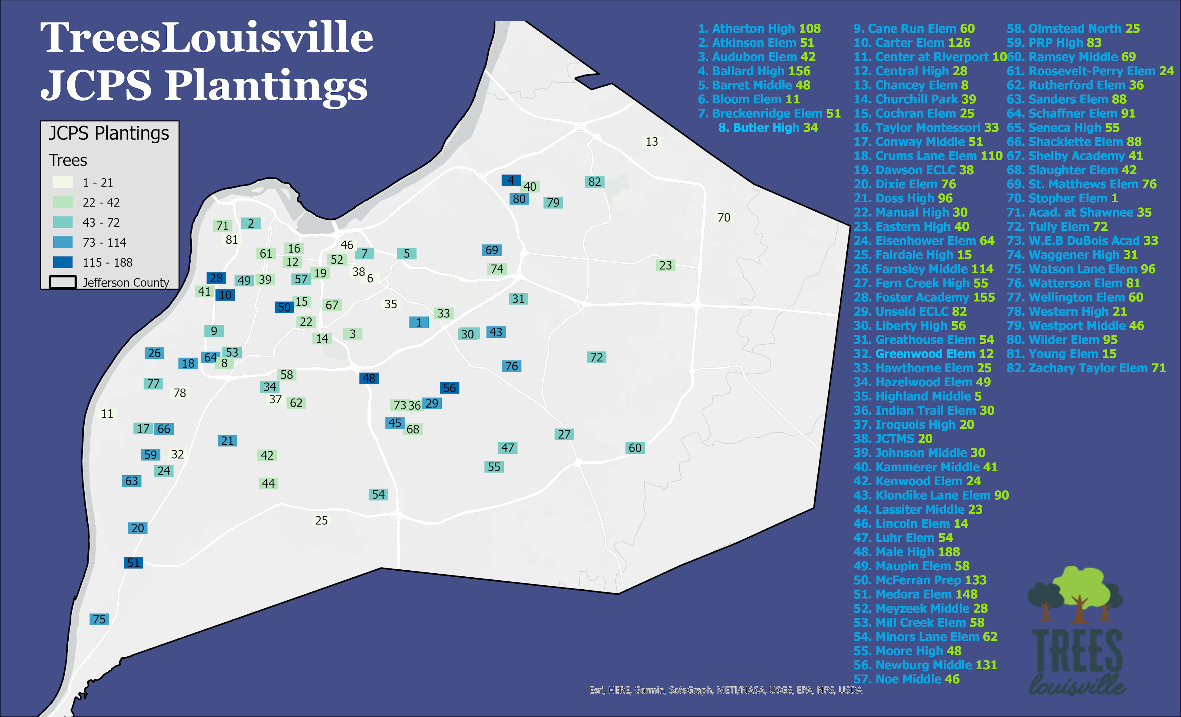
Map of every TreesLouisville tree planting at a JCPS facility and the amount of trees planted


Tools used

ArcGIS OnlineArcGIS Pro

Plug-ins used

Shape Tools

tags

canopyschoolstreeltreestreeslouisville

More by Sean Willis

Canopy Cover and Heat Severity
79
Intersection Collisions in Louisville
21
Priority Planting in Louisville, KY
123
Louisville, KY Housing Density
25
TARC Stops by Headway
15
Canopy Cover by Zip Code
128
JCPS District 4 Tree Plantings
43
Jefferson County Tax Income
61
Louisville Light Rail Proposal
89
Old Louisville Property Tax Income
17
Waste Container Inventory
22
Tree Canopy in Redlined Districts
126

You might also like

Mapa hipsométricodo município de Iramaia
Bruno Manoel Lôbo Soares
Mapa hipsométricodo município de Iramaia
Bruno Manoel...
31
Healthcare Access for LIH in LA County
Kevin Le
Healthcare Access for LIH in LA County
Kevin Le
15
Chapada do Araripe
Erika Janaina Ribeiro da Silva
Chapada do Araripe
Erika Janaina...
17
Mapa de localização e população
Eliezer Lucio Fernandes Lima
Mapa de localização e população
Eliezer Lucio...
110
Map of Abuja City, Nigeria
Balogun Temitope
Map of Abuja City, Nigeria
Balogun Temitope
1.1K
Air Pollution and Urbanization: Toronto
Volkan Ozturk
Air Pollution and Urbanization: Toronto
Volkan OzturkPro
15
Modelo Digital de Elevação - MDE
Mauricio Matheus
Modelo Digital de Elevação - MDE
Mauricio Matheus
33
Sea Level Rise in New York City
Derek R Schiavone
Sea Level Rise in New York City
Derek R Schiavone
181
Walking Analysis to Libraries in Madison
Laura Scott
Walking Analysis to Libraries in Madison
Laura Scott
41
Urban plan of Berchiesu
Katalin Peter
Urban plan of Berchiesu
Katalin Peter
21
Pecora 21 Poster
Jill Derwin
Pecora 21 Poster
Jill Derwin
19
LANDSAT8 SATELLITE MOST RECENT IMAGERY.
Karion Mohamad
LANDSAT8 SATELLITE MOST RECENT IMAGERY.
Karion Mohamad
7

Join the community!

We're a place where geospatial professionals showcase their works and discover opportunities.

Sign Up for free